FastCast—Friday, June 16 to Tuesday, June 20:
The last sun for a few days was on Thursday, as significant low pressure troughing begins to replace a brief high pressure ridge that brought sunnier weather on Thursday. Father’s Day/Juneteenth weekend will be cool, wet, and cloudy. On Friday, expect overcast skies with highs in the mid to upper 60s. Saturday will be cooler, with overcast skies and highs dropping to the low to mid 60s. Showers are possible from late Friday through Saturday, especially in a potential Convergence Zone from Northern Pierce County to Central Snohomish County. Father’s Day (Sunday) will be quite chilly with showers, with highs likely reaching the mid 50s to low 60s. Juneteenth (Monday) will also be cloudy with showers and highs again in the mid 50s to low 60s. Through this timeframe, expect lows on the chilly side, likely in the mid 40s to low 50s. Showers on Sunday and Monday will be more widespread around the lowlands, but still heaviest and most likely in the aforementioned Convergence Zone areas. Totals are likely to be in the 0.2-0.75” range, with isolated higher amounts possible. There is even a chance of high mountain snow, with snow levels near 4,500 feet. White & Chinook Passes and Paradise could see snow, with brief rain/snow mix possible at Stevens & Snoqualmie Passes. No winter-related impacts are expected except at mountain peaks. Another system is slated to move through on Tuesday, which could bring another round of more widespread rain to the region. Stay tuned!
——————————————————————
Continue reading the full blog below!
Some big changes are ahead for Washington state, with weather more reminiscent of early May expected for Father’s Day/Juneteenth weekend. Let’s take a look at the forecast.
The most significant change will be the rain. We’ll look at a couple forecasts, starting with the European model forecast through late Monday (Juneteenth).

Generally, expect 0.1-0.8” across the lowlands, with a pronounced rain shadow from North Whidbey to the Central Strait, and isolated lower rain totals in non-rain shadowed areas. Convergence Zone showers will bring higher rain totals roughly from Tacoma to Everett, with 0.3-0.8” possible, and higher amounts (1-1.5”) in parts of the Cascades, Olympics, and Coast Range. Rain will be light and isolated across Eastern WA, mainly relegated to areas near mountains.
Next, let’s take a look at the GFS forecast for rain through late Monday.

The GFS forecast shows 0.1-0.4” for most of the lowlands, except 0.5-0.7” from Seattle to Skagit County in the Convergence Zone areas. This forecast also shows 0.75-1.5” for the Cascades and Olympics.
One interesting aspect of this upcoming pattern is the prospect of light mountain snow…in June! Let’s take a look at the European model’s snow forecast below.

This forecast shows a potential for isolated mountain snow showers at times through late Monday. The actual snow level will be around 4,500 feet, meaning that brief snow is only possible at White & Chinook Passes and Paradise. These areas could see 1-3” of snow, likely less (if any) at White Pass. Brief rain/snow mix is possible at Stevens Pass and even Snoqualmie Pass.
A good question would be what’s causing all of this chilly & wetter weather. This is all explained in the upper-air pattern. First, take a look at the upper-air forecast for Thursday from the European model.

Note the red area in my black rectangle. That is the high pressure ridge that brought Thursday’s nice weather.
Now, look at the upper-air forecast for late Sunday, also from the European model.

Wow!! This is a huge difference! The ridge has been totally replaced by a massive low pressure area (called a trough). This is a very strong trough, with temperatures at 18,000 feet at -20 to -30º Celsius! We usually see features like this in winter and early spring.
Now that you know why this cooler & wetter weather is happening, it will make sense that high temperatures will be substantially cooler than recent days. Let’s look at Saturday and Sunday’s forecasted highs.
First, Saturday’s highs, seen below on the European model.
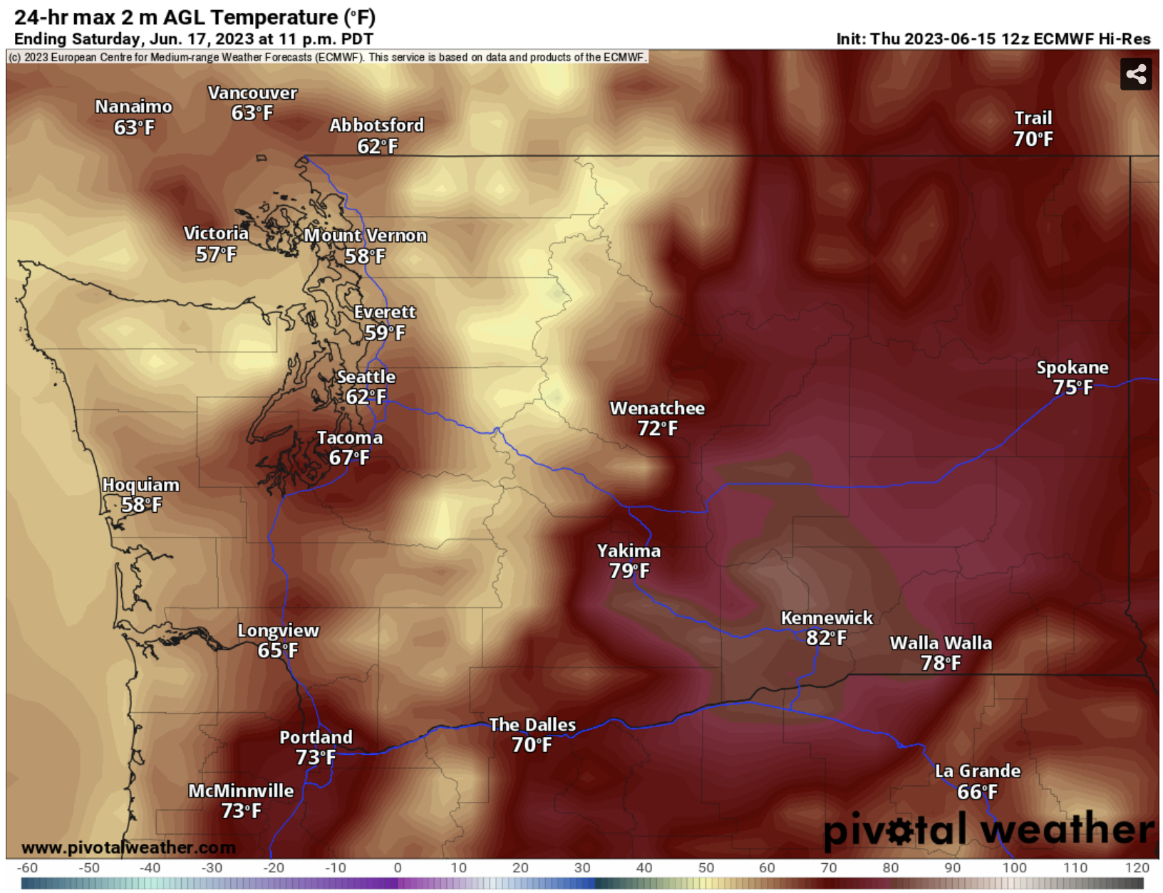
On Saturday, expect lowland highs in the low to mid 60s, with some areas remaining in the upper 50s. The coast will be in the mid to upper 50s, and Eastern Washington will reach the low 70s to low 80s. Friday will be similar to Saturday, but likely a few degrees warmer across the state.
Temperatures decline even more on Father’s Day (Sunday). Take a look at the European model’s forecast below.

Expect lowland highs in the upper 50s to low 60s, coastal highs in the mid 50s, and Eastern Washington’s highs in the mid to upper 60s. Highs will be 10-20º below average across the state.
Stay tuned for more details on this interesting weather pattern!

No comments:
Post a Comment