It's easy to tell that current conditions are quite dry across Washington state. Even with rain on Friday & Saturday, overall conditions will remain quite dry. This blog post will look at the current statistics and what they mean for the upcoming wildfire season.
Let's start with a key statistic...precipitation departure from average. We will use the very informative graphics from the Western Regional Climate Center (WRCC), starting with precipitation percent of average over the past month.

This is not a good sign. Most of Western Washington has below 5% to about 25% of average precipitation for this time. Eastern WA isn't doing much better, with below 5% to about 70% of average in most areas, with isolated areas with 90%+ of average.
This is made even worse if you compare this current graphic to the same graphic from May 2022. The difference is staggering.
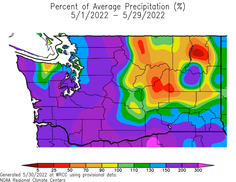
May 2022 saw 130-300% of average precipitation across Western WA, the complete opposite of this year. Areas of below-average precipitation were confined to relatively small parts of Eastern WA.
The comparison between these two graphics suggests that spring 2023 is far drier than 2022, not a good sign for wildfire season.
Another important metric when determining if wildfire season will start earlier is the snowpack. We will compare June 8, 2023 and May 30, 2022.
Below is the USDA/NRCS National Water and Climate Center snowpack graphic as of June 8.

This is, again, a huge contrast to last year. May 30, 2022 is below.

Just over one year ago, Washington's snowpack was at 140-290% of normal, meaning that we currently have less than 1/4 of 2022's late spring snowpack for most areas.
What is the difference? A warm spring. This spring has seen much higher average temperatures than 2022. Let's take a look at the comparison using WRCC graphics again.

For May and early June, the entire state of Washington has been 4-8° above average, except for Island County, Western Whatcom & Skagit Counties, the coast, and Kitsap Peninsula, which have all been 2° below average to 2° above average.
Let's compare this to May 2022.

In spring 2022, the entire state of Washington was 2-6° below average, a total change from our current situation.
So...we have made it clear that rain and snowpack are far lower than 2022 and temperature is far higher this year than 2022. This increases the risk for an early start to wildfire season.
However, even though wildfire risk has increased and conditions are drier and hotter, reservoir storage is near average.
Below is the graph for reservoir storage in the Yakima River system as of June 8th.

The blue line is our current year, the green is last year, and red is average. Notice that current reservoir storage increased dramatically in May, reaching very near average as of early June.
Let's take a look at a similar graph for the City of Seattle's reservoir system, which comprises a few reservoirs in Western Washington.

Notice that Seattle's reservoir levels also increased substantially in May, and remain near average in early June.
The key takeaway here is that despite dwindling snowpack, little rain, and warmer temperatures, water supply is good, which helps crews fight fires.
In conclusion, current conditions suggest that an earlier start to wildfire season is possible, especially in comparison to 2022. Remember to check out the links on the right side of the blog for updated wildfire information as the season gets started.

No comments:
Post a Comment