FastCast—Saturday, June 3 to Wednesday, June 7:
A sunny period is ahead for Western Washington! Through Monday, expect sunny skies, with highs in the upper 60s to mid 70s and lows in the mid to upper 40s. Breezy northerly winds off Puget Sound (known as the Sound Breeze) will be gusty on Sunday and Monday, peaking in the afternoons/evenings at 20-25 mph. Temperatures will increase next week, mainly from Tuesday to Thursday, with Wednesday being the warmest day. Details are still uncertain, but expect highs in the upper 70s to mid 80s, with lows in the low to mid 50s. Some clouds are possible in the morning on Sunday and on Monday evening, with high clouds increasing late Wednesday.
——————————————————
Continue reading the full blog below!
A very nice stretch of weather is ahead for Western Washington, with mostly sunny skies for the next few days. Let’s take a look at some forecasts!
First, let’s take a look at Saturday’s highs from the GFS model, seen below.

Expect highs in the mid to upper 70s from Everett southward, and in the upper 60s to mid 70s from Everett northward. The coast will reach the upper 50s to mid 60s, and Eastern Washington will reach the upper 70s to mid 80s.
Let’s compare this to a higher-resolution forecast, the NAM model, which tends to run a couple degrees too cool.
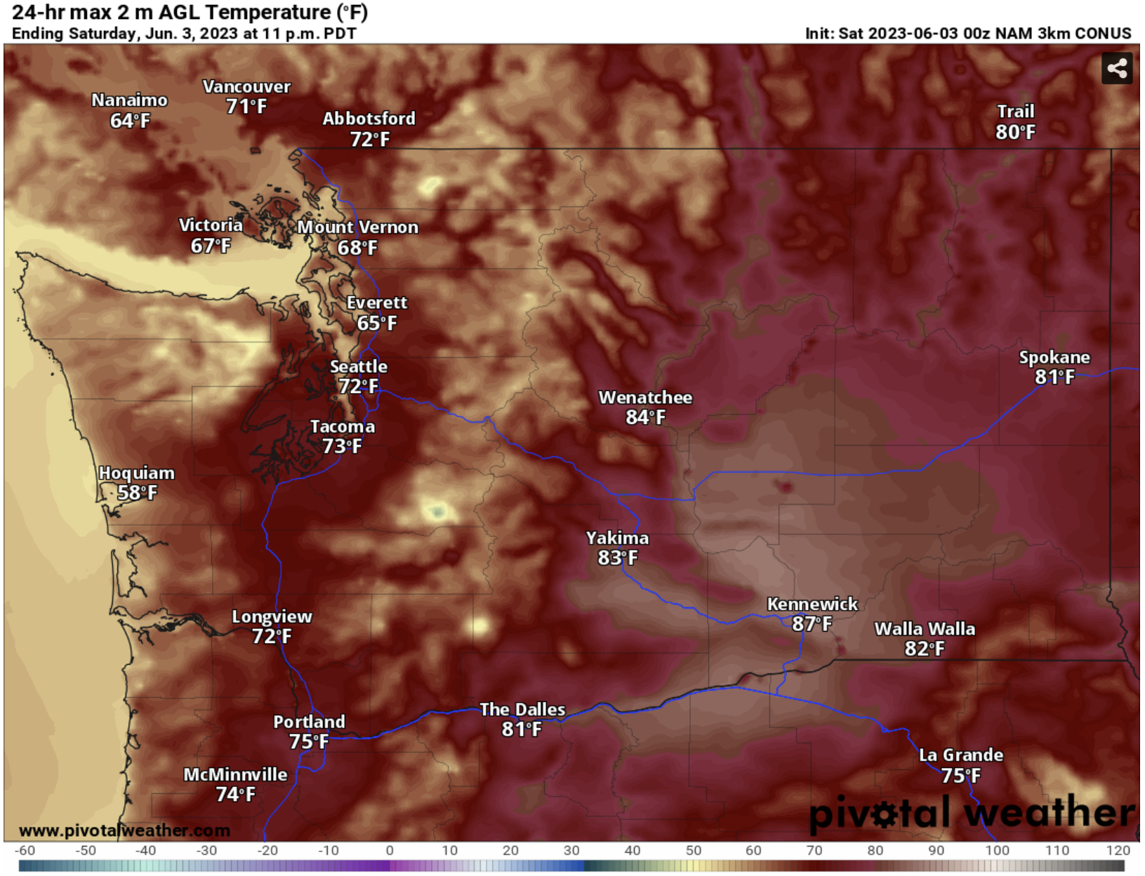
The NAM shows highs in the low to mid 70s from Everett southward and in the mid 60s to low 70s from Everett northward. The coast will reach the upper 50s, and Eastern Washington will reach the low to mid 80s, except the upper 80s in the lower Columbia Basin.
Sunday’s forecast is a bit more complex. Temperatures will be lower than Saturday, due to stronger northerly winds in the lowlands. Let’s compare the forecasts, starting with the GFS.

Notice that the GFS shows temperatures in the lowlands dropping to the mid 60s to low 70s from Everett northward, and down to the low to mid 70s from Everett southward, except cooler near the water. The coast will still reach the mid 50s to mid 60s (warmest inland) and Eastern WA will reach the low to mid 80s, except the upper 80s in the Columbia Basin.
Now let’s compare this to the NAM forecast, which is likely completely overdoing the impacts of the Sound Breeze on the temperatures.

The NAM forecast drops highs on Sunday to the upper 50s to mid 60s in Western Washington, which is unrealistically low, since it would take quite a strong wind to drop temperatures that much. I’d expect Sunday’s highs to be in the upper 60s to low 70s across the lowlands, with some isolated areas very near Puget Sound remaining in the mid 60s.
How strong will the wind be? The European model’s forecast for peak winds on Sunday afternoon is below.

Expect gusts of 20-30 mph around the lowlands and 25-35 mph on the coast. Peak gusts will be in the afternoon, and it will likely make for a chilly day on the beach and around the Sound.
The NAM forecast is relatively similar for winds, which will peak on Sunday evening, seen below.

The NAM forecast agrees with winds west of the mountains, but increases winds out of gaps in the east slopes of the Cascades, especially the Kittitas Valley and areas SE of Wenatchee, where gusts will likely reach 40-50 mph.
Overall, expect a sunny and breezy weekend (and Monday), and stay tuned for updates on the potential hotter weather next week!

No comments:
Post a Comment