Saturday, June 29, 2024

Calm Weather Continues, Significant Warmup Possible Around July 4th

 FastCast--Sunday, June 30 to Thursday, July 4:

Relatively calm weather will continue over the next few days, with a potential heat wave looming around and after July 4th. From late Saturday through Sunday morning, there will be some showers around the region. Rain totals will likely be around 0.05-0.25", most north of Everett and on the northern coast. Showers will taper by Sunday morning, giving way to partly sunny conditions, with highs in the mid 70s. Monday, Tuesday, and Wednesday will follow a similar pattern, with morning clouds and afternoon sun, with cloud coverage decreasing each day. Highs will reach the mid 70s each day. Temperatures will begin increasing starting on the Fourth, with mostly sunny skies and highs reaching the low 80s. Similar warmth and sunny skies are likely over the ensuing days. Through the Fourth, expect overnight lows in the low to mid 50s.

Hurricane Beryl: Heading for the Lesser Antilles, Jamaica, Grand Caymans, potentially Yucatan Peninsula and Belize, peak strength likely 125 mph (Category 3)

Updated Information: National Hurricane Center -- Hurricane Beryl

-------------------------------------------------------------------

Continue reading the full blog below!

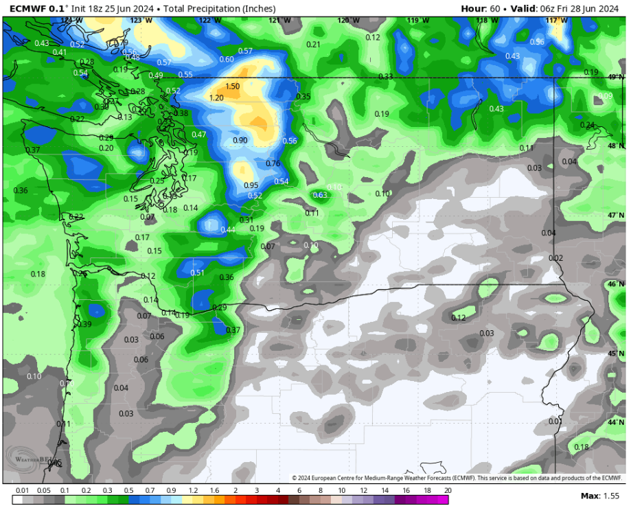
Brief showers are moving through the region this weekend, likely the last rain for the foreseeable future. The European model forecast below shows total rain through Sunday.


Most of the lowlands will receive 0.1-0.25", with similar amounts on the coast. The Blue Mountains and northern tier of the Cascades (across WA) could get up to 0.3-0.5".

Now, for the overall pattern, which will have a significant change as we go through the week. Below is the upper-air forecast for Sunday, from the European model.


Notice the very weak troughing over the Northwest (in this case, no blue shading for the troughing, just the subtle absence of a ridge). This is the pattern bringing lots of high clouds and the weekend showers.

This will completely change by the end of the week. Below is the same forecast for next Saturday.


This is a huge change! The Northwest is under a strong ridge, which will bring heat wave potential to the area, mainly from July 4th onward.

Let's take a look at the forecast for highs over the next few days, before looking at an extended forecast for the first half of July.

Below is the NWS NBM high-resolution forecast for Sunday.


On Sunday, expect lowland highs in the low to mid 70s, with the coast reaching the low to mid 60s, the Willamette Valley reaching the upper 70s to low 80s, and Eastern Washington reaching the upper 70s to low 90s (hottest around the Tri-Cities).

Next, let's take a look at Monday's forecast.


Monday is almost the exact same as Sunday, except only in the low 60s along the coast.

Next, here's Tuesday's highs.


Tuesday is very similar to Sunday and Monday, although it'll be a tad cooler around Portland, only in the mid to upper 70s.

Finally, here's a look at Wednesday's forecast. This is when a bit of a warmup will start, as the large and strong ridge builds.


On Wednesday, lowland highs will reach the mid to upper 70s (only in the low 70s for the North Sound). The coast will reach the mid 60s, and the Willamette Valley will be up to the low to mid 80s. Eastern Washington will reach the mid 80s to low 90s.

This is only the beginning of what looks to be a somewhat extended warm stretch for the Northwest. Below is the European Ensemble forecast for highs in the Seattle area over the next 14 days.


Notice how highs increase around July 4th and remain warm for the next week and longer. One thing to note is that these forecasts aren't very accurate after around 7-10 days, so the second half of the graphic is much less certain.

Stay tuned over the next few days as we start July and get closer to this potential heatwave!

Tuesday, June 25, 2024

Showers and Cooler Temperatures Return to the Northwest

 FastCast--Wednesday, June 26 to Sunday, June 30:

A noticeable change is ahead for the Northwest, with the return of cooler temperatures and showers ahead. On Wednesday, expect mostly cloudy conditions, with a chance of showers, especially from evening onward. There is also a chance of thunderstorms in the Cascades on Wednesday. Breezy winds gusting 25-35 mph are possible across the lowlands, and highs will top out in the upper 60s to low 70s. More showers are expected on Thursday, with cooler temperatures as well. Thursday's highs will only reach the mid to upper 60s, and total rain across the lowlands will be 0.05-0.25" by Thursday night. Temperatures rebound as showers move out by Friday. Highs from Friday to Sunday will likely be in the upper 60s to mid 70s, with partly to mostly cloudy skies. Overnight lows will likely be in the low to mid 50s.

------------------------------------------------------------------

Continue reading the full blog below!

Significant changes are ahead for the Northwest, with noticeably colder conditions and showers moving in. Wednesday will be on the active side, with a noticeable drop in temperatures, a chance of mountain thunderstorms, and breezy conditions. Plus, most of the region has a chance of showers. Let's take a look at the forecast!

First, we'll take a look at the forecast for 24-hour temperature change from Tuesday evening to Wednesday evening, from the NAM high-resolution forecast.


This forecast shows a significant temperature decline of 15-25° across Western WA and the Cascades from Tuesday evening to Wednesday evening.

There is also a chance of thunderstorms on Wednesday, mainly across the Cascades. Below is the European model forecast for potential lightning on Wednesday.


This forecast shows that the highest potential for thunderstorms is over the Cascades and their eastern slopes, with a smaller chance over the Olympics and extreme SE Washington.

Next, let's take a look at the wind forecast for Wednesday, seen below from the European model.


Winds will likely gust 25-35 mph across the lowlands and 30-40 mph across parts of Eastern Washington. The Columbia River Gorge will likely have gusts up to 45 mph on Wednesday.

Rain will move through in waves, with some showers on Wednesday morning, some in the evening, and more widespread showers on Thursday. Below is the European model forecast for total rain through Thursday night.


This forecast shows areas from Everett south receiving 0.1-0.25" of rain, areas Everett northward getting 0.4-0.5", the coast getting 0.2-0.5", and Eastern WA getting 0-0.6" (most in the NE mountains). The Cascades, exposed to heavier showers, will receive 0.4-1.5", most in the North Cascades.

Finally, let's talk temperatures. First, Wednesday's highs from the high-resolution NWS NBM model.


On Wednesday, expect lowland highs in the upper 60s to low 70s, coastal highs in the upper 50s to low 60s, Willamette Valley highs in the low to mid 70s, and Eastern Washington's highs in the mid 80s to low 90s, except the upper 70s in the Kittitas Valley.

Next, the NWS NBM forecast for highs on Thursday.


Thursday will be the coolest day for the lowlands, with highs in the low to mid 60s from Seattle north and the mid to upper 60s from Seattle south. The coast will reach the low 60s, the Willamette Valley will reach the low to mid 70s, and Eastern Washington will cool dramatically to the low 70s to low 80s.

Finally, let's take a look at the forecast for Friday's highs.


Temperatures will begin to rebound on Friday, with lowland highs back in the low to mid 70s, coastal highs back in the low to mid 60s, and the Willamette Valley back in the upper 70s to low 80s. Eastern Washington will reach the mid 70s to mid 80s.

It is said that summer in Seattle starts on July 5th, and that seems to be true this year!

Saturday, June 22, 2024

Brief Cooldown, Dangerous Fire Weather Conditions in Eastern WA

 FastCast--Sunday, June 23 to Thursday, June 27:

A significant, but brief, cooldown is expected across the region on Sunday, with overcast skies, a chance of light showers (especially Seattle northward and on the coast), and highs dropping to the low to mid 60s. This is caused by a weak cold front moving through, which will bring dangerous fire weather (low humidity and strong winds) to Eastern Washington. Conditions will rebound on Monday, with partly sunny skies and highs returning to the upper 60s to low 70s. Tuesday will be mostly sunny and warmer, with highs in the mid to upper 70s (and possibly the low 80s). However, a significant change is store for Wednesday and Thursday, with troughing bringing highs back down to the mid 60s, with a chance of showers (up to 0.3" for the lowlands). Through Thursday, expect overnight lows to be in the low to mid 50s.

-----------------------------------------------------------------------------

Continue reading the full blog below!

A relatively weak system moving through the Northwest on Sunday will bring a brief cooldown and dangerous fire weather to Eastern Washington. Let's take a look at the forecast!

We'll start with the NAM high-resolution forecast for 24-hour temperature change across Western Washington on Sunday afternoon.


Notice that most of the region will be 10-20° cooler than Saturday, especially in and east of the Cascades and in the Convergence Zone (between Seattle and Everett).

These significant temperature declines will be fueled by strong onshore flow moving into the area. Below is the European model forecast for peak winds on Sunday.


This forecast shows 20-30 mph gusts for Western Washington and 30-45 mph gusts in Eastern Washington. Those winds are of note, as they will fuel high fire danger.

Next, let's take a look at the forecast for relative humidity on Sunday afternoon, also from the European model.


This forecast shows relative humidity dropping to 10-20% for most of Eastern Washington, with some areas reaching values of 5-10%. These humidity values will make it very easy for fires to spread rapidly. This especially applies to any grass fires that start, which will have explosive rates of spread due to the combination of gusty winds and low humidity.

This combination of fire weather conditions has caused the NOAA Storm Prediction Center to put Eastern WA under a "critical" fire weather risk area.


In addition to this risk area, NWS offices in Spokane and Pendleton have issued Red Flag Warnings due to the fire danger.

This system will also bring a chance of light showers to Western Washington, as seen in the NWS NBM forecast below.


The best chance of showers will be on the coast (0.1-0.2"), in the Cascades (0.15-0.4") and from Seattle northward. Showers will be most likely on Sunday, tapering by Monday.

Finally, let's take a look at temperatures, from the NWS NBM high-resolution model. First, the forecast for Sunday.


This forecast shows Sunday's highs in the lowlands reaching the mid 60s, which is likely too high, as this forecast underestimates the impact of thick cloud cover. I'd expect highs in the low to mid 60s (same on the coast), and in the upper 60s to mid 70s for the Willamette Valley. Eastern Washington will reach the upper 70s to upper 80s, except only the mid 70s in the Kittitas Valley, due to strong west winds.

Temperatures begin to rebound a bit on Monday for Western WA, as seen below.


Expect the lowlands to reach the upper 60s to low 70s, the coast to reach the low to mid 60s, and the Willamette Valley to reach the upper 70s. Eastern Washington will cool to the mid 70s to mid 80s.

Finally, here's a look at the forecast for Tuesday, likely the warmest day of the week.


On Tuesday, expect lowland highs in the mid to upper 70s (isolated low 80s in the South Sound), with the coast reaching the mid 60s to low 70s, and the Willamette Valley reaching the mid to upper 80s. Eastern Washington will reach the mid 80s to mid 90s.

Stay tuned for more details about the forecast for next week, and the impending midweek cooldown.

Thursday, June 20, 2024

Hot Through Saturday, Cooler Sunday with Fire Danger

 FastCast--Friday, June 21 to Tuesday, June 25:

One of the hottest days of the year (so far) is ahead on Friday for the lowlands, with highs likely reaching the mid 80s across the region. Areas north of Everett and closer to the water will likely remain in the upper 70s to low 80s, with areas south of Tacoma and in valleys potentially reaching the upper 80s. Conditions will get cloudier and temperatures will cool somewhat on Saturday, with highs back in the upper 70s to low 80s. Further cooling and a region-wide chance of showers is ahead on Sunday, with highs dropping to the mid to upper 60s. Highs will return to the low to mid 70s on Monday and Tuesday, with partly cloudy to mostly sunny skies and a lingering chance of showers on Monday. Overnight lows through Monday will be in the low to mid 50s. There is significant fire danger in Eastern Washington on Sunday. Keep reading for more information.

-----------------------------------------------------------------------

Continue reading the full blog below!

A hot few days are expected across Washington state, with cooling later in the weekend and potentially significant fire danger in Eastern Washington on Sunday. Let's take a look at the forecast!

We'll start with the high-resolution NWS NBM model forecast for highs on Friday, seen below.


On Friday, expect highs from Seattle northward in the upper 70s to mid 80s (warmest away from the water). From Seattle southward, highs will reach the mid to upper 80s, warmest in river valleys. The coast will be cooling down a bit, with highs in the mid 60s to low 70s. The Willamette Valley will likely reach the upper 80s to low 90s, with Eastern Washington in the mid 80s to mid 90s.

On Saturday, temperatures will cool some west of the Cascades, while remaining hot on the east side. Below is the NWS NBM forecast.


On Saturday, expect lowland highs to reach the upper 70s to low 80s (cooler near the water and in the NW Interior). The coast will cool to the mid 60s, and the Willamette Valley will drop slightly to the mid to upper 80s. Eastern Washington will warm up, with highs in the upper 80s to upper 90s, hottest in the Tri-Cities area.

Sunday will see more dramatic cooling for Western WA, with some cooling in Eastern WA as well.


On Sunday, the lowlands will only reach the mid to upper 60s, with the coast remaining in the low 60s. The Willamette Valley will cool to the mid 70s, and Eastern Washington will cool to the upper 70s to upper 80s (hottest in the Columbia Basin).

However, this cooling will come at a price, especially for Eastern Washington. Below is the forecast for winds on Sunday, from the European model.


This forecast shows a breezy day west of the Cascades (20-25 mph gusts, except 30-35 mph along the Strait). However, Eastern WA is quite windy, especially in the lee of gaps in the Cascades. Gusts of 30-45 mph are expected, strongest east of the Gorge and around the Kittitas Valley.

With these winds will come very dry conditions. Below is the European model forecast for relative humidity on Sunday afternoon.


Notice the extremely low values of 10-20% across Eastern Washington. This will pave the way for rapid fire spread. Any fires that start on Sunday will have the chance of becoming out-of-control very quickly, due to strong winds, very low humidity, and overall dry conditions.

Finally, let's take a look at what will be happening on the western side of the state on Sunday and Monday. The weak weather systems ushering in cooler conditions will have some light showers and a potential Convergence Zone, as seen in the European model rain forecast below, showing rain through Monday night.


This forecast shows light rain across Western Washington, with 0-0.15" in the lowlands, up to 0.25" on the North Coast, and 0.2-0.5" in the Cascades and Olympics.

Stay tuned over the next few days for more information on the Eastern WA fire weather situation and the overall patterns we'll have to wrap up June.

Monday, June 17, 2024

Warmup Ahead as Solstice Approaches

 FastCast--Tuesday, June 18 to Sunday, June 23:

After an active couple days with showers and thunderstorms around the region, conditions will calm down, clear out, and warm up as we approach the "official" start of summer and the longest day of the year. Tuesday will begin mostly cloudy, gradually becoming mostly sunny, with highs in the upper 60s to low 70s. Mostly sunny conditions are expected from Wednesday to Friday, with highs in the mid 70s to mid 80s, warming as we get later in the week. Highs will remain in the low 80s on Saturday, with some high clouds moving through the region. A marine push is likely on Sunday, bringing breezy southwesterly winds, an influx of marine stratus clouds, and highs dropping to the mid 60s.

-----------------------------------------------------------------

Continue reading the full blog below!

After an active few days, with lots of showers around, conditions will get sunnier and drier as a ridge builds over the Northwest.

Below is the upper-air forecast for Tuesday, from the European model.


This forecast shows broad troughing across the Western US, including the Northwest, although the trough is starting to move east, giving us sunnier conditions.

Let's fast-forward to Friday, seen again on the European model.


Notice the significant change, with broad ridging across most of the US, including the Northwest. This will bring sunnier and warmer conditions to our area.

Now, let's take a look at what kind of temperatures are in store, especially with a big warmup throughout the week. These forecasts for high temperatures are from the high-resolution NWS NBM (which stands for National Weather Service National Blend of Models, a NWS-run forecast model combining the output of all major models).

First, the forecast for highs on Tuesday, seen below.


On Tuesday, expect lowland highs in the upper 60s to low 70s, coastal highs in the low 60s, Willamette Valley highs in the mid 70s, and Eastern Washington's highs in the upper 60s to upper 70s.

Wednesday will be noticeably warmer across the state, as seen below.


On Wednesday, expect lowland highs in the upper 70s (low 80s Olympia southward), coastal highs in the upper 60s to low 70s, Willamette Valley highs in the mid 80s, and Eastern Washington's highs in the mid 70s to mid 80s.

Thursday will be even warmer, as seen below.


On Thursday, expect lowland highs in the upper 70s to mid 80s, coastal highs in the upper 60s to mid 70s, and Willamette Valley highs in the mid to upper 80s (isolated low 90s possible). Eastern Washington will reach the mid 80s to low 90s, hottest in the Columbia Basin. 

Additionally, Thursday is the "official" start of summer, and the summer solstice. This means that we only have 1 hour and 58 minutes of "night", with partial twilight beginning around 2 AM and remaining until 12 AM the next morning. It will be quite a warm day that will also be the year's longest!

Finally, let's take a look at highs on Friday, seen below.


Notice that the coast has begun to cool ever so slightly as marine air starts to move back in. On Friday, the lowlands will reach the upper 70s (north of Everett) to the mid 80s (Seattle south and east). The coast will reach the upper 60s to low 70s. The Willamette Valley will be quite hot, in the upper 80s to low 90s. Eastern Washington will reach the mid 80s to mid 90s, hottest around the Tri-Cities.

Stay tuned this week as we get more accuracy in the forecast beyond this weekend, and whether we will remain warm and pleasant, or if conditions will turn cooler and potentially wetter.

Friday, June 14, 2024

Update: Thunderstorms, Snow, and Widespread Rain Ahead

No FastCast tonight...continue reading the full blog below!

An interesting weekend of weather is ahead for the Pacific Northwest, with a significant upper-level trough bringing colder conditions to the region. Expect weekend highs to only reach the upper 50s to low 60s, significantly below average for mid-June. 

The biggest threat will be thunderstorms, with storms possible across the region on Saturday, and possible for areas Seattle southward and east of the Cascades on Sunday. 

Let's take a look at the European model forecast lightning flash density, showing the potential areas for thunderstorms Saturday afternoon.


This forecast shows the entirety of Western Washington has a chance of thunderstorms, highest over the lowlands from Thurston to Snohomish Counties. Eastern Washington has an even higher chance of thunderstorms, especially for Okanogan, Ferry, Stevens, Pend Orielle, Spokane, and Whitman Counties.

There is also a chance of isolated thunderstorms as strong showers move in early Saturday morning, from 4-7 AM. Below is the high-resolution HRRR model forecast for lightning flash density at 6 AM.


This forecast shows a chance of thunderstorms as showers move through the region early Saturday. This chance is highest for Island and Skagit Counties.

Instability in the atmosphere will be quite high by Saturday afternoon, and this is a key metric in determining if there is a good likelihood of thunderstorms. Below is the CAPE index forecast (showing amount of instability) on Saturday afternoon from the NAM high-resolution model.


This forecast shows high CAPE for Western Washington, with values of 400-800 possible, and values of 100-500 in Eastern WA. These are significant values for the Pacific Northwest, and indicate that there is a good potential for thunderstorms.

Rain will be widespread in Western Washington this weekend, with most areas receiving rain at times. Below is the NWS NBM forecast for rain through the weekend.


This forecast shows most of Western Washington receiving 0.1-0.3" of rain, with areas under heavier showers (specifically in the Convergence Zone from the King/Snohomish County line to SE Whatcom County) receiving 0.4-0.6". The Cascades will receive 0.75-2.5", highest where Convergence Zone bands move into the mountains.

The colder nature of this system will also drive down snow levels to around 4,500 feet, bringing some accumulating snow to higher passes and recreation areas. Below is the European model forecast for total snow through the weekend.


This forecast shows Paradise and the North Cascades Highway (between Diablo and Winthrop) getting up to 3-6" of snow, with higher amounts possible at Paradise. Stevens and White Passes could see a dusting to 1" of snow.

Finally, it will be another windy day for Eastern Washington on Saturday, with breezy conditions at times for Western WA. Below is the European model forecast for peak gusts through Saturday.


This forecast shows 25-30 mph gusts in the lowlands, mainly from Seattle southward. Eastern Washington will be much windier, with gusts of 40-45 mph for most of the region, except potentially up to 50 mph around the Blue Mountains. This is of concern due to the 1,150-acre Nisqually John Fire, burning west of Clarkston along the Snake River. Winds of 40+ mph will allow this fire to potentially experience significant growth on Saturday.

Remember, with active weather ahead and a chance of thunderstorms, be prepared to seek shelter if you hear thunder/see lightning, and be prepared for gusty winds, heavy rain, and even small hail. If you're in the backcountry, be prepared for cold and potentially snowy conditions. It sure won't feel like June for a few days!

Thursday, June 13, 2024

Active June Weather: Thunderstorms, Chilly Temperatures, and High Mountain Snow

 FastCast--Friday, June 14 to Tuesday, June 18:

An interesting few days of weather is ahead for the Pacific Northwest. A chilly upper-level trough will bring showers and a region-wide chance of thunderstorms this weekend, with cold air aloft bringing snow levels down to 4,500 feet as well. Across the lowlands, expect highs in the upper 50s to mid 60s from Friday to Monday, quite chilly for this time of year. Lows will generally be in the mid to upper 40s. Showers will move through at times from midday Friday through Sunday, becoming more sporadic by Sunday. Rain totals will vary wildly across the region because of where thunderstorms will move through. If thunderstorms or strong cells move through your area, expect rain totals up to 0.4-0.8" by Sunday. Areas under the Convergence Zone could have even more rain. If you don't have any storms, your totals will likely be closer to 0-0.25". Mountain areas higher than 4,500 feet (including Paradise on Mt. Rainier and the North Cascades Hwy) will receive snow, up to 4-8". By Tuesday, lowland conditions will become sunnier, with highs increasing back to the low 70s.

Remember, with any shower or thunderstorm this weekend, the threats are thunder, lightning, small hail, gusty winds, and heavy rain. Take precautions and seek shelter!

--------------------------------------------------------------------

Continue reading the full blog below!

An incoming upper-level trough will bring chilly and active weather to the Pacific Northwest over the next few days. Let's take a look at the forecast!

We'll start with thunderstorms...the upper-level trough brings very cold air aloft, which increases instability in the atmosphere, bringing a region-wide chance of thunderstorms on Saturday and Sunday (to a lesser extent). 

Below is the European model forecast for lightning flash density (the chance of lightning at a given point) for Saturday afternoon.


This is 6-hour lightning flash density, showing the chance of thunderstorms for a 6-hour period on Saturday afternoon. As you can see, the highest chance of thunderstorms is over the Okanogan Mountains of NE WA, over the lowlands from Thurston County to Vancouver BC, and over parts of the Columbia Basin.

However, the forecast above is showing an average chance of thunderstorms over a 6-hour period, so let's take a look at 1-hour lightning flash density for around 1 PM Saturday.


As you can see, this forecast is much more precise, showing the potential locations of thunderstorms on Saturday afternoon. This underscores the lowlands, NE WA, and parts of the Columbia Basin as being the most likely areas for thunderstorms to develop on Saturday afternoon.

Another good metric for thunderstorm chances is to look at the forecast for amount of instability in the atmosphere. This is measured on the CAPE index (CAPE stands for Convective Available Potential Energy). Below is the NAM high-resolution CAPE forecast for Saturday afternoon.


This forecast shows respectable CAPE values of 200-800 across Western Washington, with values of 100-500 in Eastern Washington. These are good values for our neck of the woods, and they show that thunderstorms are definitely possible on Saturday, especially from ~11 AM onward.

Now, let's take a look at the rain forecast from the high-resolution NWS NBM model. This shows rain through Sunday night.


This forecast shows 0.25-0.5" of rain for most of the lowlands, with potential areas of higher precipitation (0.5-0.9") between Everett and Bellingham. The coast will get 0.5-0.75", and the Cascades will receive 1-1.5".

However, for some parts of the Cascades, the cold nature of this system will bring June snow. Below is the European model forecast for total snow through Sunday night.


This forecast shows Paradise getting up to 6-8" of snow, with the main passes getting a dusting to 2", and the North Cascades Highway getting 3-5". Be prepared for winter driving conditions if you will be in these areas, and bring traction devices as a precaution.

Finally, let's take a look at temperatures. Saturday will be the coolest day of this stretch, seen below on the NWS NBM model.


This forecast shows lowland highs only reaching the upper 50s to low 60s, with the coast reaching the mid 50s to low 60s, the Willamette Valley reaching the mid 60s, and Eastern Washington only reaching the mid 60s to low 70s. Mountain locations may not make it out of the mid 40s (or mid 30s at Paradise).

The European model forecast below shows temperature departure from average on Saturday afternoon.


This forecast shows lowland and coastal temperatures running 5-10° below average, with the Willamette Valley and Eastern WA likely 10-15° below average. The Cascades will be an impressive 15-25° below average on Saturday afternoon!

In short...quite an interesting period of weather is ahead, especially the thunderstorm potential. With that in mind, stay tuned for an update tomorrow (Friday) night!

Monday, June 10, 2024

Calm & Comfortable Weather Continues

 FastCast--Tuesday, June 11 to Saturday, June 15:

Calm and relatively comfortable weather will continue across the region through this week. Expect a chance of light showers on Tuesday morning, with some lingering showers into the afternoon for the North Sound. Conditions will likely clear up and become mostly sunny by the afternoon. Winds could gust 25-35 mph across the region on Tuesday. Wednesday will also feature morning clouds and afternoon sun, with Tuesday and Wednesday's highs in the upper 60s to low 70s. Thursday will be partly cloudy with filtered sunshine due to high clouds, but highs will reach this week's peak, in the low to mid 70s. Conditions will get cooler and cloudier on Friday, with showers moving in during the afternoon and highs dropping to the low to mid 60s. Similar conditions are expected on Saturday, with a potential for thunderstorms across the region, which bears watching. Lows throughout the week will likely be in the upper 40s. Stay tuned for more information!

-------------------------------------------------------------------

Continue reading the full blog below!

A chance of showers is expected across Western Washington to begin Tuesday, with relatively calm weather expected for the rest of the week. Let's take a look at the forecast!

Below is the NAM high-resolution model's rain forecast, showing total rain through late Tuesday.


This forecast shows light showers (0-0.1") across the lowlands, with 0.1-0.3" on the coast, and 0.25-0.5" possible in the mountains. Eastern Washington will remain dry and warm.

The entire state will see elevated winds as this system moves through on Tuesday. Below is the European model forecast for peak gusts on Tuesday.


Expect gusts of 25-35 mph across the lowlands, with isolated gusts over 35 mph. Eastern Washington will be on the windy side, with gusts of 40-45 mph possible. This is of note due to two ongoing early-season fires, the 400-acre Pioneer Fire along the northern shore of Lake Chelan, an area that could see gusts of 35-40 mph. The Training Center Fire, which burned 4,000 acres in the Yakima Training Center on Monday, is 100% contained but bears monitoring with 45+ mph gusts possible.

Now, let's take a look at temperatures for the next few days. Below is the NWS NBM forecast for highs on Tuesday.


Expect lowland highs in the mid 60s to low 70s, with the coast reaching the upper 50s to low 60s, Willamette Valley reaching the mid 70s, and Eastern Washington reaching the mid to upper 80s, except in the mid 70s for the Kittitas Valley.

Next, let's take a look at Wednesday's highs.


On Wednesday, expect highs in the mid 60s to low 70s for the lowlands, the low to mid 60s on the coast, mid 70s in the Willamette Valley, and mid 70s to low 80s in Eastern Washington (note the cooling effect of Tuesday's system).

Thursday will likely be the warmest day of the week for Western Washington, as seen below.


Expect lowland highs in the low to mid 70s, with the coast reaching the mid to upper 60s, the Willamette Valley reaching the upper 70s to low 80s, and Eastern Washington returning to the upper 70s to mid 80s.

Conditions will begin cooling statewide on Friday, as more systems and potential thunderstorms take aim at the region.


Friday's highs will reach the low to mid 60s in the lowlands, upper 50s to low 60s on the coast, low 70s in the Willamette Valley, and the mid 70s to low 80s across Eastern Washington.

There are potential chances for thunderstorms across the state on Saturday and in the following days, with Saturday being the best chance for Western Washington. Stay tuned for more information!

Next Storm System Hits Western Washington

  8-26 Video Briefing: Next Storm System Hits Western Washington