FastCast--Wednesday, June 26 to Sunday, June 30:
A noticeable change is ahead for the Northwest, with the return of cooler temperatures and showers ahead. On Wednesday, expect mostly cloudy conditions, with a chance of showers, especially from evening onward. There is also a chance of thunderstorms in the Cascades on Wednesday. Breezy winds gusting 25-35 mph are possible across the lowlands, and highs will top out in the upper 60s to low 70s. More showers are expected on Thursday, with cooler temperatures as well. Thursday's highs will only reach the mid to upper 60s, and total rain across the lowlands will be 0.05-0.25" by Thursday night. Temperatures rebound as showers move out by Friday. Highs from Friday to Sunday will likely be in the upper 60s to mid 70s, with partly to mostly cloudy skies. Overnight lows will likely be in the low to mid 50s.
------------------------------------------------------------------
Continue reading the full blog below!
Significant changes are ahead for the Northwest, with noticeably colder conditions and showers moving in. Wednesday will be on the active side, with a noticeable drop in temperatures, a chance of mountain thunderstorms, and breezy conditions. Plus, most of the region has a chance of showers. Let's take a look at the forecast!
First, we'll take a look at the forecast for 24-hour temperature change from Tuesday evening to Wednesday evening, from the NAM high-resolution forecast.

This forecast shows a significant temperature decline of 15-25° across Western WA and the Cascades from Tuesday evening to Wednesday evening.
There is also a chance of thunderstorms on Wednesday, mainly across the Cascades. Below is the European model forecast for potential lightning on Wednesday.

This forecast shows that the highest potential for thunderstorms is over the Cascades and their eastern slopes, with a smaller chance over the Olympics and extreme SE Washington.
Next, let's take a look at the wind forecast for Wednesday, seen below from the European model.

Winds will likely gust 25-35 mph across the lowlands and 30-40 mph across parts of Eastern Washington. The Columbia River Gorge will likely have gusts up to 45 mph on Wednesday.
Rain will move through in waves, with some showers on Wednesday morning, some in the evening, and more widespread showers on Thursday. Below is the European model forecast for total rain through Thursday night.
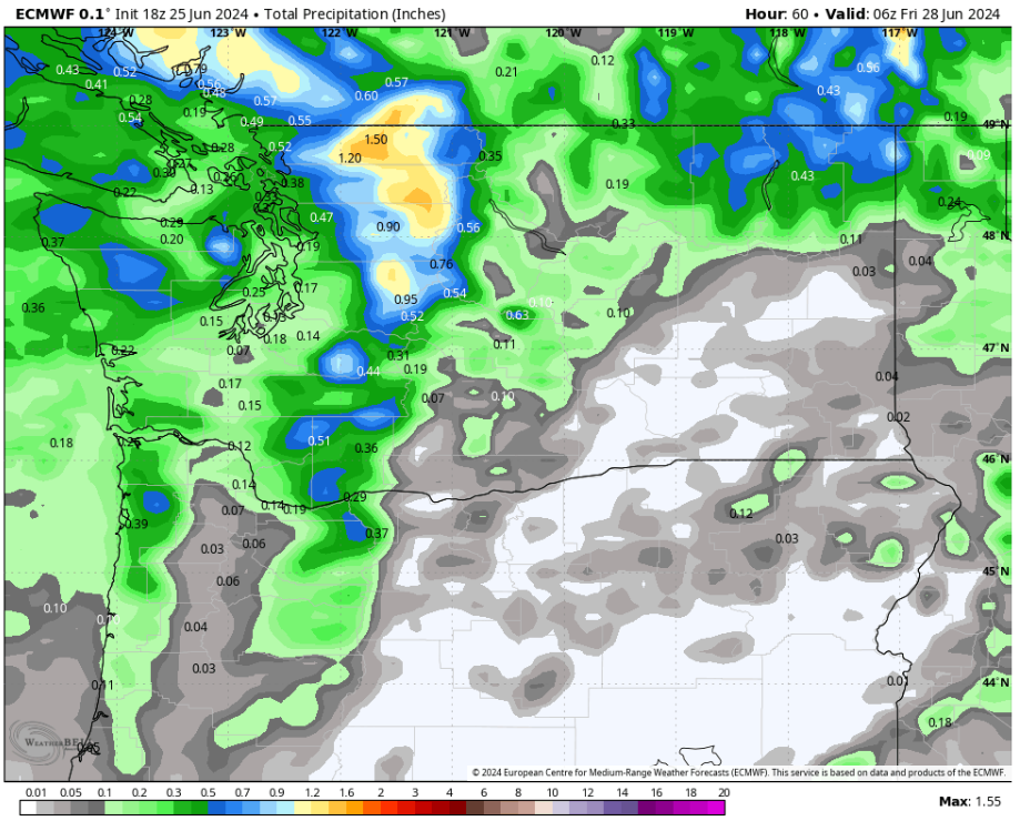
This forecast shows areas from Everett south receiving 0.1-0.25" of rain, areas Everett northward getting 0.4-0.5", the coast getting 0.2-0.5", and Eastern WA getting 0-0.6" (most in the NE mountains). The Cascades, exposed to heavier showers, will receive 0.4-1.5", most in the North Cascades.
Finally, let's talk temperatures. First, Wednesday's highs from the high-resolution NWS NBM model.

On Wednesday, expect lowland highs in the upper 60s to low 70s, coastal highs in the upper 50s to low 60s, Willamette Valley highs in the low to mid 70s, and Eastern Washington's highs in the mid 80s to low 90s, except the upper 70s in the Kittitas Valley.
Next, the NWS NBM forecast for highs on Thursday.

Thursday will be the coolest day for the lowlands, with highs in the low to mid 60s from Seattle north and the mid to upper 60s from Seattle south. The coast will reach the low 60s, the Willamette Valley will reach the low to mid 70s, and Eastern Washington will cool dramatically to the low 70s to low 80s.
Finally, let's take a look at the forecast for Friday's highs.

Temperatures will begin to rebound on Friday, with lowland highs back in the low to mid 70s, coastal highs back in the low to mid 60s, and the Willamette Valley back in the upper 70s to low 80s. Eastern Washington will reach the mid 70s to mid 80s.
It is said that summer in Seattle starts on July 5th, and that seems to be true this year!

No comments:
Post a Comment