FastCast--Friday, June 14 to Tuesday, June 18:
An interesting few days of weather is ahead for the Pacific Northwest. A chilly upper-level trough will bring showers and a region-wide chance of thunderstorms this weekend, with cold air aloft bringing snow levels down to 4,500 feet as well. Across the lowlands, expect highs in the upper 50s to mid 60s from Friday to Monday, quite chilly for this time of year. Lows will generally be in the mid to upper 40s. Showers will move through at times from midday Friday through Sunday, becoming more sporadic by Sunday. Rain totals will vary wildly across the region because of where thunderstorms will move through. If thunderstorms or strong cells move through your area, expect rain totals up to 0.4-0.8" by Sunday. Areas under the Convergence Zone could have even more rain. If you don't have any storms, your totals will likely be closer to 0-0.25". Mountain areas higher than 4,500 feet (including Paradise on Mt. Rainier and the North Cascades Hwy) will receive snow, up to 4-8". By Tuesday, lowland conditions will become sunnier, with highs increasing back to the low 70s.
Remember, with any shower or thunderstorm this weekend, the threats are thunder, lightning, small hail, gusty winds, and heavy rain. Take precautions and seek shelter!
--------------------------------------------------------------------
Continue reading the full blog below!
An incoming upper-level trough will bring chilly and active weather to the Pacific Northwest over the next few days. Let's take a look at the forecast!
We'll start with thunderstorms...the upper-level trough brings very cold air aloft, which increases instability in the atmosphere, bringing a region-wide chance of thunderstorms on Saturday and Sunday (to a lesser extent).
Below is the European model forecast for lightning flash density (the chance of lightning at a given point) for Saturday afternoon.
This is 6-hour lightning flash density, showing the chance of thunderstorms for a 6-hour period on Saturday afternoon. As you can see, the highest chance of thunderstorms is over the Okanogan Mountains of NE WA, over the lowlands from Thurston County to Vancouver BC, and over parts of the Columbia Basin.
However, the forecast above is showing an average chance of thunderstorms over a 6-hour period, so let's take a look at 1-hour lightning flash density for around 1 PM Saturday.
As you can see, this forecast is much more precise, showing the potential locations of thunderstorms on Saturday afternoon. This underscores the lowlands, NE WA, and parts of the Columbia Basin as being the most likely areas for thunderstorms to develop on Saturday afternoon.
Another good metric for thunderstorm chances is to look at the forecast for amount of instability in the atmosphere. This is measured on the CAPE index (CAPE stands for Convective Available Potential Energy). Below is the NAM high-resolution CAPE forecast for Saturday afternoon.
This forecast shows respectable CAPE values of 200-800 across Western Washington, with values of 100-500 in Eastern Washington. These are good values for our neck of the woods, and they show that thunderstorms are definitely possible on Saturday, especially from ~11 AM onward.
Now, let's take a look at the rain forecast from the high-resolution NWS NBM model. This shows rain through Sunday night.
This forecast shows 0.25-0.5" of rain for most of the lowlands, with potential areas of higher precipitation (0.5-0.9") between Everett and Bellingham. The coast will get 0.5-0.75", and the Cascades will receive 1-1.5".
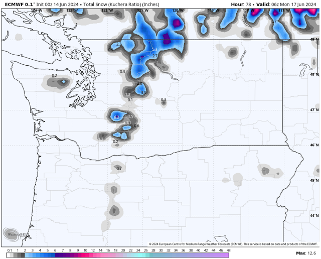
However, for some parts of the Cascades, the cold nature of this system will bring June snow. Below is the European model forecast for total snow through Sunday night.
This forecast shows Paradise getting up to 6-8" of snow, with the main passes getting a dusting to 2", and the North Cascades Highway getting 3-5". Be prepared for winter driving conditions if you will be in these areas, and bring traction devices as a precaution.
Finally, let's take a look at temperatures. Saturday will be the coolest day of this stretch, seen below on the NWS NBM model.
This forecast shows lowland highs only reaching the upper 50s to low 60s, with the coast reaching the mid 50s to low 60s, the Willamette Valley reaching the mid 60s, and Eastern Washington only reaching the mid 60s to low 70s. Mountain locations may not make it out of the mid 40s (or mid 30s at Paradise).
The European model forecast below shows temperature departure from average on Saturday afternoon.
This forecast shows lowland and coastal temperatures running 5-10° below average, with the Willamette Valley and Eastern WA likely 10-15° below average. The Cascades will be an impressive 15-25° below average on Saturday afternoon!
In short...quite an interesting period of weather is ahead, especially the thunderstorm potential. With that in mind, stay tuned for an update tomorrow (Friday) night!


No comments:
Post a Comment