FastCast--Tuesday, June 11 to Saturday, June 15:
Calm and relatively comfortable weather will continue across the region through this week. Expect a chance of light showers on Tuesday morning, with some lingering showers into the afternoon for the North Sound. Conditions will likely clear up and become mostly sunny by the afternoon. Winds could gust 25-35 mph across the region on Tuesday. Wednesday will also feature morning clouds and afternoon sun, with Tuesday and Wednesday's highs in the upper 60s to low 70s. Thursday will be partly cloudy with filtered sunshine due to high clouds, but highs will reach this week's peak, in the low to mid 70s. Conditions will get cooler and cloudier on Friday, with showers moving in during the afternoon and highs dropping to the low to mid 60s. Similar conditions are expected on Saturday, with a potential for thunderstorms across the region, which bears watching. Lows throughout the week will likely be in the upper 40s. Stay tuned for more information!
-------------------------------------------------------------------
Continue reading the full blog below!
A chance of showers is expected across Western Washington to begin Tuesday, with relatively calm weather expected for the rest of the week. Let's take a look at the forecast!
Below is the NAM high-resolution model's rain forecast, showing total rain through late Tuesday.

This forecast shows light showers (0-0.1") across the lowlands, with 0.1-0.3" on the coast, and 0.25-0.5" possible in the mountains. Eastern Washington will remain dry and warm.
The entire state will see elevated winds as this system moves through on Tuesday. Below is the European model forecast for peak gusts on Tuesday.

Expect gusts of 25-35 mph across the lowlands, with isolated gusts over 35 mph. Eastern Washington will be on the windy side, with gusts of 40-45 mph possible. This is of note due to two ongoing early-season fires, the 400-acre Pioneer Fire along the northern shore of Lake Chelan, an area that could see gusts of 35-40 mph. The Training Center Fire, which burned 4,000 acres in the Yakima Training Center on Monday, is 100% contained but bears monitoring with 45+ mph gusts possible.
Now, let's take a look at temperatures for the next few days. Below is the NWS NBM forecast for highs on Tuesday.

Expect lowland highs in the mid 60s to low 70s, with the coast reaching the upper 50s to low 60s, Willamette Valley reaching the mid 70s, and Eastern Washington reaching the mid to upper 80s, except in the mid 70s for the Kittitas Valley.
Next, let's take a look at Wednesday's highs.

On Wednesday, expect highs in the mid 60s to low 70s for the lowlands, the low to mid 60s on the coast, mid 70s in the Willamette Valley, and mid 70s to low 80s in Eastern Washington (note the cooling effect of Tuesday's system).
Thursday will likely be the warmest day of the week for Western Washington, as seen below.

Expect lowland highs in the low to mid 70s, with the coast reaching the mid to upper 60s, the Willamette Valley reaching the upper 70s to low 80s, and Eastern Washington returning to the upper 70s to mid 80s.
Conditions will begin cooling statewide on Friday, as more systems and potential thunderstorms take aim at the region.
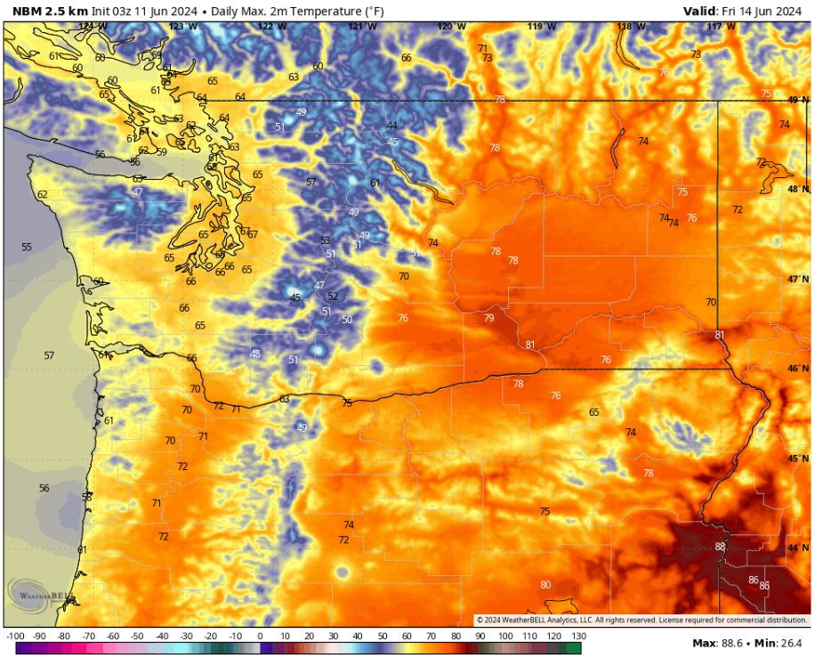
Friday's highs will reach the low to mid 60s in the lowlands, upper 50s to low 60s on the coast, low 70s in the Willamette Valley, and the mid 70s to low 80s across Eastern Washington.
There are potential chances for thunderstorms across the state on Saturday and in the following days, with Saturday being the best chance for Western Washington. Stay tuned for more information!

No comments:
Post a Comment