FastCast--Thursday, Aug. 1 to Monday, Aug. 5:
Heat, smoke, and potential thunderstorms are returning to the Northwest. In the lowlands, temperatures will likely remain hot for the next few days. On Thursday, expect highs in the upper 70s to low 80s north of Everett and in the mid 80s to low 90s south of Everett. Friday will have some high clouds moving through the region, but highs will still be hot. Expect the northern lowlands to reach the upper 70s to low 80s again, with the southern lowlands in the mid to upper 80s. Temperatures will remain similar on Saturday as more high clouds move through. The heat builds back on Sunday, as clouds move out. Highs will reach the upper 70s to mid 80s north of Everett (warmest away from the water), and will reach the upper 80s to low 90s from Everett southward. Monday will be similar, with highs dropping a tad to the mid to upper 80s from Everett southward. As usual, with heat waves, overnight lows will be on the warm side. Expect the metro area to remain in the low to mid 60s, while outlying areas will drop to the upper 50s. Wildfire smoke aloft may cause hazy skies at times. Keep reading for more details!
----------------------------------------------------------------------
Continue reading the full blog below!
After a brief respite from hot weather, expect heat, smoke, and potential thunderstorms to return to the Pacific Northwest as we begin August. Let's take a look at the forecast!
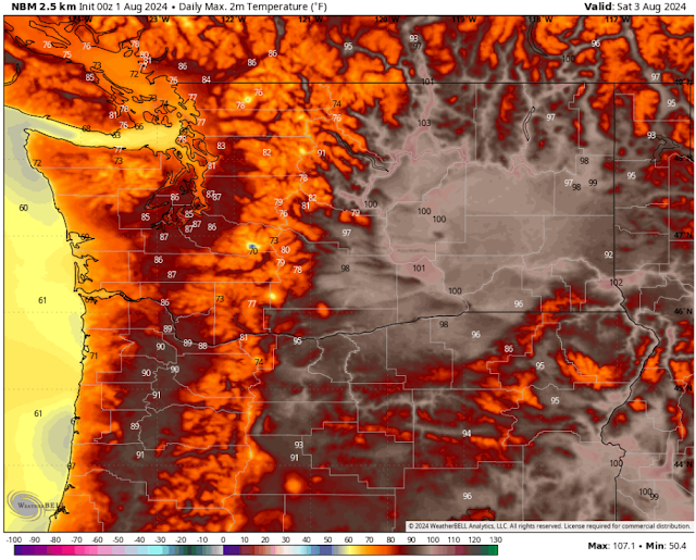
We'll start with the forecast for highs on Thursday, from the NWS NBM model.
On Thursday, expect highs from Everett northward to reach the upper 70s to low 80s, while areas from Everett southward reach the mid 80s to low 90s. The Willamette Valley will be very hot, with highs in the upper 90s, while Eastern Washington will reach the upper 90s to mid 100s. The coast will be quite warm, in the low 70s to low 80s, with some areas reaching the mid 80s (mainly inland from the beaches).
Friday will be dangerously warm in Eastern Washington and cooler west of the Cascades, due to high clouds moving through. The NWS NBM forecast is below.
On Friday, expect highs from Everett northward to reach the low to mid 80s, while areas from Everett southward reach the mid to upper 80s. The Willamette Valley will reach the low to mid 90s, and the coast will cool to the mid 60s to low 70s. Eastern Washington will be dangerously hot, with highs in the mid to upper 100s, with isolated highs in the low 110s. Please be very aware of the dangers of this heat if you are in Eastern WA on Friday.
On Saturday, temperatures will drop some in Eastern WA, while dropping a bit more due to cloud cover west of the Cascades.
Expect Saturday's highs to reach the upper 70s to mid 80s from Everett northward, the mid 80s from Everett southward, and the upper 80s to low 90s around the Willamette Valley. The coast will reach the mid 60s to low 70s, and Eastern Washington will drop to the mid 90s to low 100s, except some valleys will remain in the mid 100s.
Sunday brings more of the same, with a slight increase in temperatures west of the Cascades.
On Sunday, highs from Everett northward will reach the upper 70s to mid 80s, with areas from Everett south reaching the upper 80s to low 90s. The Willamette Valley will reach the mid 90s, and Eastern WA will reach the mid 90s to mid 100s (hottest near the Tri-Cities). The coast will again reach the mid 60s to low 70s.
The reason for this extended heat wave is a massive high pressure ridge across the Western United States, seen below in the European ensemble forecast for Friday.
Notice the darker orange over Washington and parts of Idaho and British Columbia. That's where the ridge is located. Its position allows for hot temperatures in the Northwest, along with the ability for monsoonal moisture to move north into the region.
That monsoonal moisture will bring yet another potential round of dry thunderstorms to Oregon and Washington. The highest chance of this for Washington looks to be on Friday, as seen in the potential lightning forecast from the European model.
This forecast shows a chance of dry thunderstorms over the Cascades, mountains of NE WA, and the Blue Mountains on Friday afternoon. It's likely that any lightning strikes that aren't accompanied by rain could start new fires. Additionally, outflow winds from thunderstorms could exacerbate conditions on existing fires.
Finally, let's take a brief look at smoke conditions, seen on the HRRR smoke forecast. First, the forecast for smoke aloft on Friday morning.
There will be moderate concentrations of smoke aloft across most of Western Washington, with somewhat heavier concentrations over Eastern Washington. This will likely move out during the day on Friday, remaining light through Saturday.
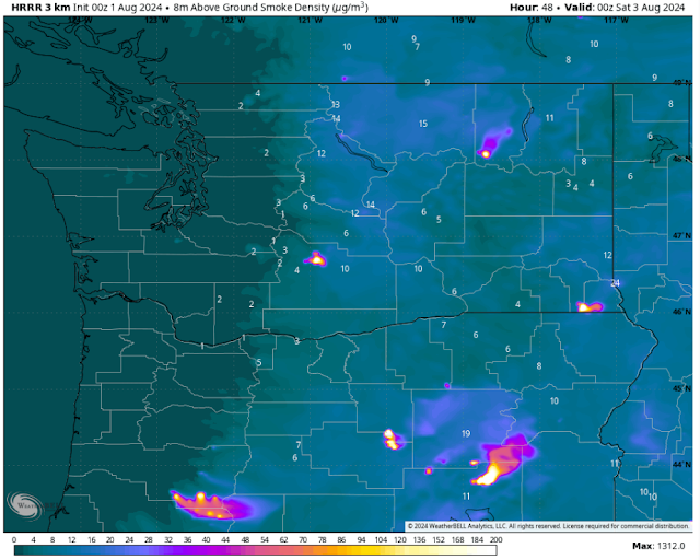
Surface smoke is a bit of a different story. It will be almost entirely relegated to areas from the Cascades eastward, as seen in this forecast for Friday afternoon.
Notice that surface smoke is almost nonexistent west of the Cascade crest. Expect degraded air quality to remain relegated to areas in and east of the mountains, worst downwind of fires.
Stay tuned for more information as this interesting weather continues!


No comments:
Post a Comment