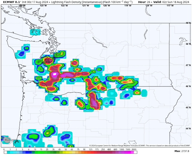
A significant thunderstorm event looks likely across Washington & Oregon on Saturday, possibly stretching into Sunday morning. We'll take an in-depth look at the forecast in this blog post, with another update by midafternoon Saturday.
Let's start with the European model forecast for lightning. This first frame is for 7 PM Saturday.
At 7 PM, the European model shows a line of storms moving north through the southern portions of WA, having just passed through the Portland metro area. At this time, storms are beginning to move into the Olympia and Tacoma areas, with stronger storms moving northward through Lewis and Cowlitz counties.
Next, here's a look at the forecast for 8 PM.
By 8 PM, a significant thunderstorm is slamming the metro area from Seattle south through Olympia. This would have frequent lightning, heavy rain, and strong winds. It is very rare to see this kind of forecast for Western Washington!
Let's continue onward, now to 9 PM.
By 9 PM, the line of storms stretches from the Central WA Coast toward the Cascades, with strong thunderstorms impacting the Seattle metro area. This shows a very significant thunderstorm event for the metro area.
After this, storms will likely begin weakening and moving north, with uncertainty remaining about another potential round of scattered storms impacting the metro area from 12-4 AM Sunday.
However, uncertainty remains about what time storms will impact the metro area. We'll take a look at the HRRR and NAM high-resolution forecasts to see more about timing. These forecasts are essentially simulated weather radar, showing what the radar could look like as the thunderstorms move in.
First, the HRRR high-resolution forecast.
The HRRR shows storms impacting the metro area starting around 8-9 PM, continuing for 3-4 hours after that.
Let's compare to the NAM forecast, seen below.
The NAM has a similar-looking radar image as the HRRR does, but shows storms moving into the metro area a bit later, around 9-10 PM.
Basically, storms are most likely from Olympia northward in the 8-11 PM timeframe, potentially continuing into early Sunday morning (becoming more scattered). For more frequent updates, join the Western WA Weather Facebook group (click here or the logo on the right side of the blog).
There are more threats than just lightning with these thunderstorms. The biggest additional threats are rain and wind. Wind is very difficult to predict, and there is still significant model disagreement on what will actually happen. Stay tuned for future updates regarding wind potential.
Below is the NAM high-resolution forecast for total rain through Sunday.
This forecast shows significant, dangerous totals in the Cascades, with 1-3" for the Washington Cascades, including over burn scars, which could bring debris flows and flash flooding. Over the lowlands, this forecast shows 0.6-1.25" of rain from Olympia to Everett, and 0.15-0.4" elsewhere. This is significant for summer, and will bring standing water and potential urban flooding.
Let's compare this to the European model's rainfall forecast, seen below (also through Sunday).
This forecast shows storms moving more south to north vs. the NAM, which shows more SE to NW movement. The European model gives the I-5 corridor from Chehalis to Arlington 0.6-1.1", with the rest of Western WA getting 0.3-0.7", most on the Kitsap Peninsula. Isolated mountain locations could get over 1.1".
Finally, let's take a look at the NWS Storm Prediction Center (SPC) outlook for Washington.
This is extremely rare! This outlook shows a marginal (dark green) risk of severe thunderstorms for Portland, most of King and Pierce Counties, and most of the WA Cascades. An even rarer slight risk (yellow) is in place for the Southern WA Cascades and Oregon Cascades.
What does this mean? The SPC is noticing the potential that thunderstorms will be strong enough to be severe-warned, which means wind gusts could exceed 58 mph, and there could be large hail (likely confined to the mountains, if at all).
Wow!! That's a lot of information! If you've made it this far, thanks for reading all the way! Stay tuned on Facebook for more information and frequent updates. I will have one final blog post update by midafternoon Saturday.
In the meantime, don't forget to keep your devices charged, as thunderstorms can cause power outages, especially when there's a wind component. Stay tuned!


No comments:
Post a Comment