Monday, March 8, 2021

Mostly Dry With Chilly Nights This Week

Monday morning was quite chilly, especially for March in the Seattle area! Take a look at low temperatures on the graphic below.


Brrr! Low temperatures of 24-32 degrees were observed across the area. 

Monday was mostly cloudy, due to a weather system rotating offshore. 

In the UW forecast model below, you can see that rain showers don’t really make it to Puget Sound.


The Puget Sound area will receive light showers, mainly Monday night and Tuesday, totaling 0 to 0.05 inches.

Below is the Puyallup forecast from Weather Underground, showing partly-mostly sunny conditions this week, before showers return for the weekend.


Expect highs of 50-60 degrees (warmest on Friday), with morning lows of 30-35 degrees.

Frost is possible in the mornings this week, but expect it to thaw quickly as the temperatures warm in the mornings.


Saturday, March 6, 2021

Showers & Breezy On Sunday Then A Transition To Drier Weather

After a couple days of showers, periodically breezy conditions, and some sunbreaks, another weather system will move in on Sunday.

Rain will move in early Sunday morning, becoming scattered showers through the day Sunday. Below is the expected rain through 4 PM Monday from the UW model.


Expect light rain, totaling 0.05 to 0.25 inches. Notice that there’s “lines” of heavier rain on the map above. That shows that there will be heavier showers at times. 

There is also a chance of thunderstorms on Sunday, mainly from mid-morning to late afternoon. In any storm cell, be prepared for heavy rain, gusty winds, and potential hail and lightning.

Sunday will also be breezy. Below is the 4-model forecast for Puyallup.


Expect winds gusting 20 to 40 mph, mainly from early Sunday morning into the early evening. As always, some localized tree damage and isolated power outages are possible.

As showers and clouds move out of the area Sunday night, temperatures will drop into the low 30s. 


After the weather system moves out Sunday night, expect a nice week with little rain. High temperatures will be in the mid-upper 50s, with lows in the 30s. 

Some frost is possible in the mornings this week. Since we are getting into springtime, frost can impact plants that are starting to grow. Pay attention to forecast low temperatures if you’re growing plants. 

Wednesday, March 3, 2021

Rain Returns, Cooler Temperatures After Thursday

Wednesday was a beautiful day! It was mostly sunny with temperatures of 55-64 degrees. Take a look at the high temperatures below.


Before we get to Thursday’s weather...also take a look at Wednesday’s morning low temperatures, which reached the upper 20s-low 30s.

Thursday will be mostly cloudy, but southerly winds will warm the temperature to the upper 50s-low 60s across most of the area.

Rain will move in by Thursday evening, and the area will receive 0.2-0.75 inches of rain by 4 PM Saturday.


The most rain will fall Thursday night and Friday morning, and rain will continue (more showery) through at least the weekend.

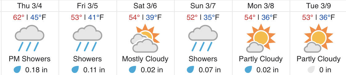
Below is the Puyallup forecast from Weather Underground through the beginning of next week.


Temperatures reach 62 degrees on Thursday, cooling to the low-mid 50s for the rest of the timeframe.

Enjoy the warm day on Thursday!

Next Storm System Hits Western Washington

  8-26 Video Briefing: Next Storm System Hits Western Washington