Friday, August 5, 2022

Brief Heat Wave & Smoke Slowly Returns

FastCast—Saturday, Aug. 6 to Wednesday, Aug. 10:

Seafair weekend has arrived in Seattle, and the weather will be on the warm side. Expect highs on Saturday to be in the low to mid 80s for the region (low 80s near the water). Sunday and Monday will both reach the upper 80s to low 90s in the lowlands, with foothill and SW Interior locations coming closer to the mid 90s. Overnight lows from Saturday to Monday will be in the upper 50s to low 60s. For Eastern Washington, another stretch of highs in the upper 90s to mid 100s is expected from Saturday to Tuesday. Lows will only drop into the mid 60s to low 70s. Relief comes statewide by Wednesday, but even sooner in the lowlands. Highs on Tuesday will drop back to the low to mid 80s, with clouds increasing in the evening. A system will move through overnight into Wednesday, bringing a chance of showers to the region. Highs will drop to the mid to upper 70s on Wednesday, with abundant clouds. We will be dealing with light surface smoke on Sunday due to Eastern Washington wildfires, as well as light smoke aloft due to those same fires. Thicker smoke aloft from California may arrive by late Sunday evening. Stay tuned!

————————————————————————

Continue reading the full blog below!

Sunny weather will prevail for the entirety of Seafair weekend in Seattle! Temperatures will be increasing with a brief heat wave for the region, though it will be a few degrees cooler along the water. 

The GFS forecast for Saturday is below. This forecast tends to be 2-3 degrees hotter than actual temperatures for Washington State.


On Saturday, expect lowland highs in the upper 70s to low 80s near the water and in the mid 80s away from the water. The foothills may reach the upper 80s to near 90. Offshore flow will bring temperatures in the 70s to the ocean beaches. The Portland area and Eastern Washington will be in the low to mid 90s on Saturday.

Sunday and Monday will be the hottest days of this heat wave. We will take a look at Sunday’s highs. Again, this forecast is likely 2-3 degrees too warm.


This will be the first of the 2 hottest days in the upcoming mini heat wave. Expect highs on Sunday to be in the low to mid 80s near the water and in the upper 80s to low 90s elsewhere in the lowlands. The foothills and SW Interior (Olympia area) will reach the low to mid 90s. The coast will again be dominated by offshore flow, with temperatures in the mid 70s to near 80 at the beaches, and even warmer inland. The Portland area and Eastern Washington will reach the mid 90s to near 100.

These temperatures will not be as hot as the previous heat wave, and this heat wave will not be nearly as long as the previous one, only lasting into early next week.

However, wildfire smoke is making a return to Western Washington. Although it will be light, the recent developments of wildfires in Eastern Washington have brought a potential for light near-surface smoke by Sunday.

The forecast for smoke aloft is below, from the HRRR model.


By this time, 3 PM Sunday, a veil of light smoke aloft will cover Western Washington due to offshore flow on Saturday and Sunday. This flow will change to southerly (from the south) later on Sunday, bringing a new round of thicker California smoke aloft. Stay tuned for more information about that.

Additionally, as mentioned earlier, there will be some light concentrations of smoke near the surface by Sunday afternoon, according to the HRRR forecast below.


This forecast shows very light surface smoke concentrations, due to Eastern Washington wildfires. No significant impacts to air quality are expected at this time, though that can change, so stay tuned by clicking the air quality link on the right side of the blog and typing in your city.

Stay tuned for updates on the end of the heat wave, the potential rain next week, and the wildfire smoke situation.

Wednesday, August 3, 2022

Chance of Rain, Then the Next Hot Stretch Arrives

FastCast—Thursday, Aug. 4 to Monday, Aug. 8:

Wednesday was a pleasant—and average—summer day for the Seattle area. It began overcast and ended up mostly sunny with highs in the mid 70s and a refreshing marine breeze. Clouds are increasing and showers will move through Western Washington late Wednesday night through Thursday morning. Thursday will be the coolest and cloudiest day in the near future. Highs will only reach the mid 60s to low 70s, coolest by the water. Total rain from a weak band of showers will be 0.05-0.15 inches in the Seattle area and up to 0.2-0.5 inches from Mount Vernon northward and in the Cascades. The coast will pick up 0.1-0.2 inches. A big change arrives on Friday. Flow will shift from onshore to northerly, clearing out clouds. Friday’s highs will reach the mid to upper 70s around the lowlands. Saturday will be even warmer, with highs in the low to mid 80s. Sunday and Monday will be the hottest days of the upcoming mini heat wave, with highs likely in the upper 80s to low 90s around the area, with areas in the foothills, valleys, and Olympia area likely hitting the mid 90s. Low temperatures will be in the low 50s by Thursday morning and will slowly rise, reaching the upper 50s to low 60s by Sunday and Monday mornings. Stay tuned for updates on the upcoming hot stretch.

—————————————————————

Continue reading the full blog below!

A chance of rain is in the forecast! A weak front will move from NW to SE across Western Washington overnight Wednesday into Thursday morning, and it will bring a chance of showers to the area. The HRRR rain forecast is below.

This is the first rain forecast in weeks on this blog! Expect 0.05-0.15 inches of rain in the metro area. North of Mount Vernon and in the Cascades, totals will reach 0.2-0.5 inches!

Since this is a weak system, rain will fizzle before reaching Eastern Washington, although there will be cooler temperatures as a result of this weak system. The NAM forecast for Thursday’s highs is below.


It will be a cool day, with highs in the mid 60s to low 70s in the lowlands. Eastern Washington will experience their coolest temperatures in quite a while, with highs reaching the upper 70s to upper 80s.

Friday morning lows will be very refreshing after all the heat we have experienced lately. The NAM forecast is below.


Wow! Expect lows dropping to the low 50s for the lowlands, with some outlying locations dipping into the upper 40s on Friday morning! Even Eastern Washington will drop into the mid 50s to low 60s.

However, the cooler temperatures and cloudy weather will not last long. Sun returns on Friday and a gradual warmup begins. A ridge of high pressure will be rebuilding offshore and moving over the Pacific Northwest. By Sunday, temperatures will be soaring back into the low 90s for parts of Western Washington. The GFS (American model) forecast is below.


While this forecast model tends to be 2-3 degrees too hot, Western Washington will still experience 2-3 days in the mid 80s to low 90s, with more upper 90s to low 100s coming for Eastern Washington and the Portland area. The good news is that this mini heat wave will be short-lived, with temperatures returning to the low 80s by next Tuesday.

Stay tuned for more information in upcoming blogs!

Sunday, July 31, 2022

Gradual Cooldown Begins After Major Heat Wave

FastCast—Monday, Aug. 1 to Friday, Aug. 5:

After an all-time record 6 consecutive days at 90+ degrees in Seattle, this weeklong heat wave will gradually come to an end. Expect Monday’s highs in the lowlands to be in the low to mid 80s. In Eastern Washington, relief will be virtually nonexistent, with highs reaching the mid 90s to low 100s on Monday and Tuesday, before finally cooling to the mid 80s to low 90s after that. Back to the lowlands…Tuesday through Friday will be in the mid to upper 70s, a huge relief after this heat wave. Expect overnight lows in the mid to upper 50s, seasonable for August. Additionally, clouds will return for the first time in over a week due to the return of onshore flow. Expect morning clouds every day except Friday. On Friday, flow turns northerly, eliminating most clouds. We will make another (potentially extended) run into the 80s starting next Saturday.

————————————————————

Continue reading the full blog below!

From many individual records to Seattle’s longest stretch above 90 degrees, this was a significant heat wave for the Pacific Northwest. It will be remembered not for its temperature values, but for its longevity. It will try and hold on a bit longer than previously anticipated, especially in Eastern Washington. Let’s take a look at the forecast.

The HRRR high-resolution forecast for Monday is below, showing approximate high temperatures.


Expect highs in the low to mid 80s in the lowlands, coolest near the Sound and hottest east of I-5. The Portland area will reach the mid 80s to low 90s. Eastern Washington will continue baking, with highs in the mid 90s to mid 100s yet again. This heat wave has been quite bad for Western Washington, and just plain brutal on the east side of the mountains, with the Tri Cities Airport reaching 100+ degrees for 8 consecutive days, with 2-3 more days above 100 degrees ahead.

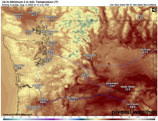
Western Washington will really feel the marine influence on Monday evening and through the night. Take a look at the NAM forecast for lows on Tuesday morning.


Lows in Western Washington will reach the upper 50s to low 60s, the coolest in nearly a week. Even Eastern Washington will be a bit cooler, with lows dropping to the upper 60s to low 70s, after a week with lows as high as 80 degrees.

Tuesday will finally be a near-average summer day in Western Washington, as seen in the NAM forecast below.


Expect lowland highs in the upper 60s near the water and the mid to upper 70s in the interior! Eastern Washington will continue gradually cooling down, with highs in the low 90s to low 100s. Portland will drop to the mid 80s.

Stay tuned for more information on the seasonable weather ahead and the potential chance of some showers in Western Washington later this week. You can find Sunday’s high temperatures below.

Information about the explosive McKinney Fire near Klamath River, California (near the CA/OR border, west of Yreka) can be found below:

McKinney Fire InciWeb Page

Sunday High Temperatures:


Next Storm System Hits Western Washington

  8-26 Video Briefing: Next Storm System Hits Western Washington