Sunday, October 30, 2022

Sunday Night Atmospheric River & Wind Update

No FastCast tonight…continue reading below for an update on the ongoing atmospheric river and gusty winds.

A rainy and windy night is ahead for the Puget Sound area. After a prolific rain shadow dominated the weather pattern today, the atmospheric river will fill in the rain shadow as it moves south. Take a look at the crazy rain shadow in the graphic below.

This is an incredible example of the rain shadow effect. With westerly flow all day Sunday, the west slopes of the Olympics picked up 3-8 inches of rain, while just 50 miles away, Seattle had under 0.05”. The Cascades and lowland areas from Everett northward receive 0.5-2 inches as well.

Rain will fill in the mostly dry areas overnight. Let’s take a look at the HRRR high-resolution forecast for rain through 12 AM Tuesday.


The HRRR shows 0.8-1.25 inches in the lowlands, 0.25-1.25 inches in Eastern Washington, and 1-3 inches on the coast. With snow levels over 7,000 feet, the mountains will pick up 3-6 inches of rain.

Let’s compare this with the NAM high-resolution forecast, also through 12 AM Tuesday.


The NAM shows a different solution, with substantially less rainfall over the lowlands and the Portland area. The NAM shows a big rain shadow between Seattle and Olympia. This is a big difference from the HRRR forecast.

The European model sides more with the HRRR, showing a wetter solution through Monday night.


The European model shows 0.8-1.5 inches in the lowlands and Portland area. 

In addition to the heavy rain, it will be breezy to windy across the region from Sunday night into Monday morning. The HRRR forecast is below for gusts at 12 AM Monday.


The HRRR shows gusts peaking at 35-45 mph around the lowlands and coast overnight into Monday morning.

The NAM also shows windy weather. Below is the NAM forecast for gusts at 11 PM Sunday.


The NAM shows strong gusts of 40-50 mph around the lowlands & coast. This is likely a bit too strong, but gusty winds are still possible.

In short, be prepared for steady rain (heavy at times) and gusty winds overnight Sunday, with winds calming by Monday morning and rain continuing (but tapering gradually) through midday Monday. Be prepared for isolated tree damage, power outages, and standing water through Monday.

Heavy rainfall over burn scars in the Cascades has a potential for debris flows, flash flooding, and landslides through Monday. Accordingly, NWS Seattle has issued a Flash Flood Watch for the Cascades. Additionally, large waves are possible on the WA & OR Coasts on Monday, with 20-25 foot surf possible. Stay safe on the beaches.

Active weather will continue into the first week of November. Stay tuned to the blog & Twitter for updates!

Saturday, October 29, 2022

Halloween Weekend Atmospheric River Bringing Significant Rain and Gusty Winds

FastCast—Sunday, Oct. 30 to Tuesday, Nov. 1:

A much more robust atmospheric river is ahead for the Pacific Northwest from Sunday through late Monday (Halloween). Winds will increase on Sunday morning, gusting 25-35 mph around the region all day. Winds will be higher (35-45 mph) from Everett northward, on the coast, and along the water. Rain will spread slowly from north to south throughout Sunday, with initial rain shadowing for the Central Sound, before rain increases in the evening. Rain will continue through Monday, likely tapering to showers by Monday evening, so showers are possible for trick-or-treating around the area. Rain totals will be substantial, reaching 0.75-1.5 inches for the entire Puget Sound area, with a potential for totals up to 1.75-2 inches. Snow levels will skyrocket to 7,000-8,000 feet, bringing significant rain to the mountains. Amounts of 3-6 inches will fall in the mountains (1.5-2 inches in the foothills), and the coast will receive 1.5-3 inches. Rivers will rise significantly from their lingering summer levels, but river flooding is not expected, although some rivers will reach bankfull. The atmospheric river will bring warmer temperatures, with Sunday morning lows in the upper 40s and afternoon highs in the mid 50s. Tuesday will bring continued showers, but much cooler weather, with highs in the upper 40s and lows in the upper 30s to low 40s.

—————————————————————

Continue reading the full blog below!

The first significant atmospheric river of the season is ahead for Western Washington, bringing the biggest rainfall since late spring. The UW forecast below shows the atmospheric river aimed right at Western Washington late Sunday night.


The forecast above shows integrated water vapor transport, which is essentially the amount of water vapor in the atmosphere. Late Sunday night, a current of high water vapor values will be aimed right at Western Washington.

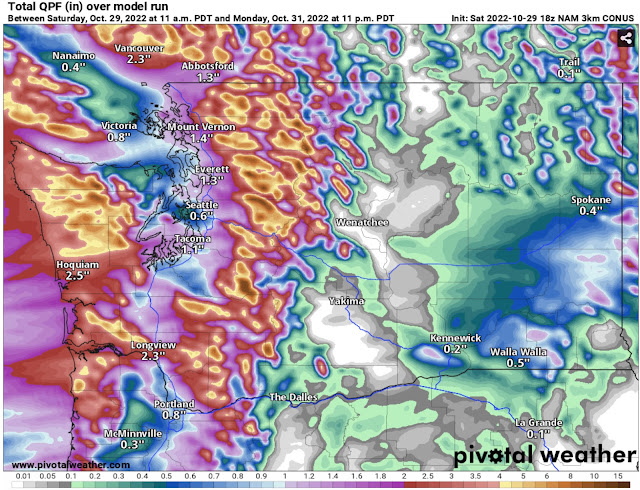
Let’s take a look at the rain totals. Below is the NAM model, representing the lower side of potential totals (through 11 PM Monday).


The NAM shows 0.5-1.5 inches of rain for the lowlands, with the most from Everett northward and the least in the rain shadow around Seattle and Bremerton and on the NE Olympic Peninsula. The coast and mountains pick up 2-6 inches, and even parts of Eastern Washington get 0.25-0.75 inches, with up to 1.25 inches south of Spokane!

Next is the HRRR forecast, which represents a wetter solution. This shows rain through 5 PM Monday, a bit earlier than the NAM forecast.


This forecast brings much more rain to the lowlands than the NAM forecast does, while lessening rain for the Willamette Valley and Eastern Washington. The lowlands will get drenched with 1-2 inches of rain, the most between Seattle and Tacoma. The foothills and areas from Olympia to Kelso will receive 1.5-3 inches, and the coast and mountains will be soaked by 3-6 inches.

With these forecasts showing the entire spectrum of possible rainfall, it is safe to expect amounts of around 0.8 to 1.5 inches for the lowlands.

Another element of this atmospheric river will be the winds, which will be strongest during the day Sunday. Note: gusts of 30-35 mph are expected during the Seahawks game on Sunday afternoon.

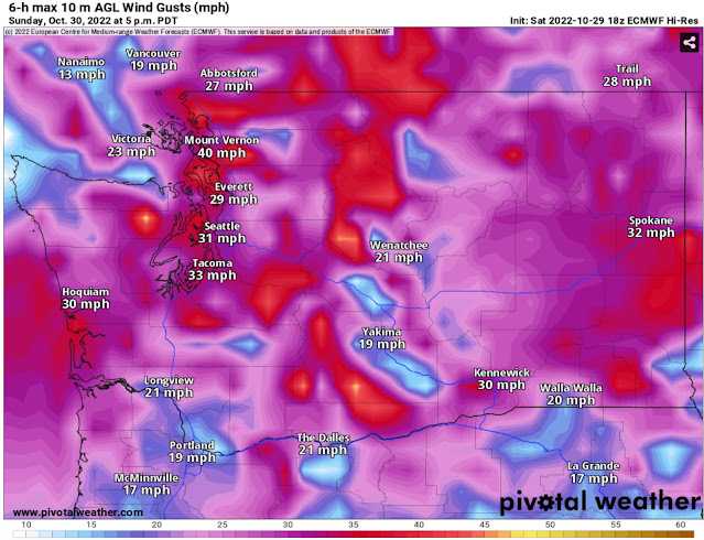
Below is the European model forecast for winds on Sunday afternoon.


The European model shows gusts of 30-35 mph around the lowlands and 35-40 mph north of Everett and on the coast. Winds will be strongest along the water.

Below is the NAM forecast for winds at 1 PM Sunday, showing a stronger solution (that is more unlikely).


The NAM forecast predicts winds around the entire region gusting up to 35-40 mph on Sunday afternoon.

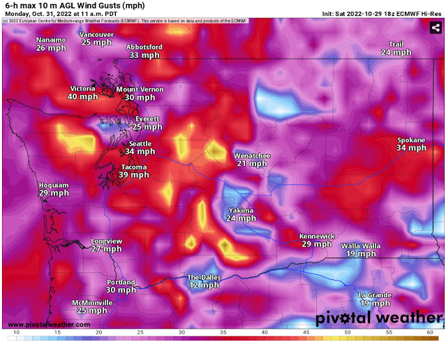
The European model forecast shows a secondary surge of winds early on Monday, seen below


This secondary wind surge may have gusts of 30-40 mph around the lowlands, with stronger gusts of 40-45 mph along the Strait of Juan de Fuca, on the coast, and in the mountains. Parts of Eastern Washington could have gusts of 30-40 mph as well.

One final note about this atmospheric river…snow levels will be very high. The influx of subtropical air from the atmospheric river will surge snow levels to 7,000-8,000 feet. The NAM forecast below shows snowfall through 11 PM Monday.


Snow accumulation will be very spotty except at higher elevations. However, the major mountain peaks may receive over 3 feet of snow!

Stay tuned for updates on Twitter and stay tuned to the blog for more updates as active weather continues!

Wednesday, October 26, 2022

Weak Atmospheric River Bringing Rain & Gusty Winds

 FastCast—Thursday, Oct. 27 to Sunday, Oct. 30:

The next system, which will be a weak atmospheric river, will arrive in Western Washington on Thursday. The main impact on Thursday will be gusty winds ahead of the system. A Wind Advisory is in effect for the coast and areas from Everett northward, with NWS Seattle expecting gusts up to 50 mph for most of the day Thursday, but peaking in the afternoon. The rest of the region will have gusts of 30-35 mph, with some spots (mainly exposed areas or areas near the water) reaching up to 40 mph. Rain from the weak atmospheric river will move from north to south late Thursday night, continuing into Friday morning. Expect 0.3-0.7 inches of rain in the lowlands, with 0.75-1 inch from Skagit County northward. The coast and mountains will receive 1.5-3 inches. Snow levels will rise to around 6,000 feet with this warmer system, and lowland highs on Thursday will be in the upper 50s to low 60s. Conditions will be calm and overcast from midday Friday through Saturday evening, with highs in the mid 50s and lows in the upper 40s. Another atmospheric river is poised to arrive late Saturday night, lasting into Monday morning. While details are still uncertain, this looks to be a stronger atmospheric river, that may bring 1-2 inches of rain to the lowlands and 3-5 inches to the coast and mountains, along with gusty winds and high snow levels. Stay tuned!

——————————————————

Continue reading the full blog below!

A weak atmospheric river (essentially a slow-moving cold front in this event) will impact Western Washington with gusty winds and rain on Thursday and Friday. The UW forecast below shows the weak atmospheric river aimed at Western Washington at 8 PM Thursday.


The atmospheric river will bring another round of rain to the area, but it will also bring gusty winds. This is because the atmospheric river will be slowly pushed south by a cold front, and the pressure gradient ahead of that cold front will produce gusty winds around the region. We’ll take a look at the winds first.

Below is the forecast for peak winds from the European model.


This forecast shows Thursday’s gusts topping out around 30-35 mph from Everett southward, with 40-50 mph gusts possible from Everett northward and on the coast. The European model shows peak winds on Thursday afternoon.

The NAM forecast for 10 AM Thursday shows a similar story.


The NAM shows similar gusts as the European, but differs with an earlier time for peak winds, generally midmorning to early afternoon.

Usually we don’t look at 3 different forecasts for one event, but something is showing up in the HRRR forecast that is worth noting.


The HRRR forecast above (3 PM Thursday) shows a narrow area of strong wind gusts due to a meso-low. In this instance, a meso-low is a small area of low pressure that forms on the leeward (wind-sheltered) side of the Olympic Mountains. The HRRR shows this meso-low bringing a narrow area of winds gusting up to 50-55 mph (black rectangle), stretching roughly from the Hood Canal Bridge to Shoreline.

Regardless of small weather features like a meso-low, Thursday’s winds will be enough to cause isolated tree damage and spotty power outages in the South & Central Sound, with a higher threat of tree damage and power outages from Everett northward and on the coast. Be prepared for these threats.

Now for the rain…let’s take a look at the European model forecast for rain through 5 AM Friday.


This forecast shows 0.5-0.8 inches of rain in the lowlands from Everett southward to Portland. It gives the North Sound 0.75-1.25 inches, and the mountains and coast get 1-3 inches.

Now, let’s compare this to the NAM forecast through 5 AM Friday.

The NAM gives lesser amounts to the lowlands, showing 0.3-0.6 inches, with even less south of Olympia. The NAM gives the North Sound 0.5-1.25 inches and the mountains/coast get 0.5-3 inches. 

This atmospheric river has the potential to cause flash flooding near area burn scars, especially the Bolt Creek Fire burn scar along US-2 from Index to Skykomish. With the combination of higher snow levels and heavy rain, be prepared for sudden flash flooding or debris flows near burn scars.

Finally, the mountain snow outlook. Atmospheric rivers have a subtle subtropical element, meaning that they bring warmer temperatures and higher snow levels. Forecasts show that snow levels in the Cascades will rise to 5,500-6,000 feet by Thursday night. The NAM forecast below (through 5 AM Friday) shows little snowfall in the mountains.


Due to high snow levels, most snow accumulation with this system will be confined to elevations over 5,500-6,000 feet. A trace to 2 inches of snow is possible at the higher passes before changing over to rain.

A potentially stronger atmospheric river is ahead for Western Washington, with rain possible from late Saturday night through Monday morning, along with gusty winds. Then, we may transition to an overall colder pattern to begin November, so stay tuned!

Monday, October 24, 2022

Another Round of Active Weather on Tuesday

 FastCast—Tuesday, Oct. 25 to Thursday, Oct. 27:

Another system is ahead for Western Washington on Tuesday. This system will bring more rain than on Monday. Rain will start around noon, with showers lasting into the night. Expect 0.4-0.7 inches in the lowlands on Tuesday, with isolated spots getting less. There will be a rain shadow in the traditional area of the NE Olympic Peninsula. The coast and mountains will receive 1-3 inches of rain, and areas from Olympia southward have a chance to get over 0.8”. Additionally, Tuesday will be breezy, with winds gusting 20-30 mph around the area. Stronger winds, gusting up to 35-40 mph, are possible Tuesday afternoon/evening during frontal passage. Snow levels will again be around 4,000 feet, with 2-6 inches of new snow at the higher passes, and up to 12-24 inches on peaks over 8,000 feet. 2-12 inches of snow are also expected in the Olympics and Blue Mountains. Conditions will be drier on Wednesday, with highs in the low to mid 50s and lows in the low to mid 40s. There is a chance for a round of light rain on Wednesday night. Thursday will be dry in the morning, with the next round of rain arriving later in the day. Stay tuned!

———————————————————

Continue reading the full blog below!

Another weather system will impact Western Washington on Tuesday. This system will bring more rain than Monday’s system, with another round of breezy conditions and mountain snow.

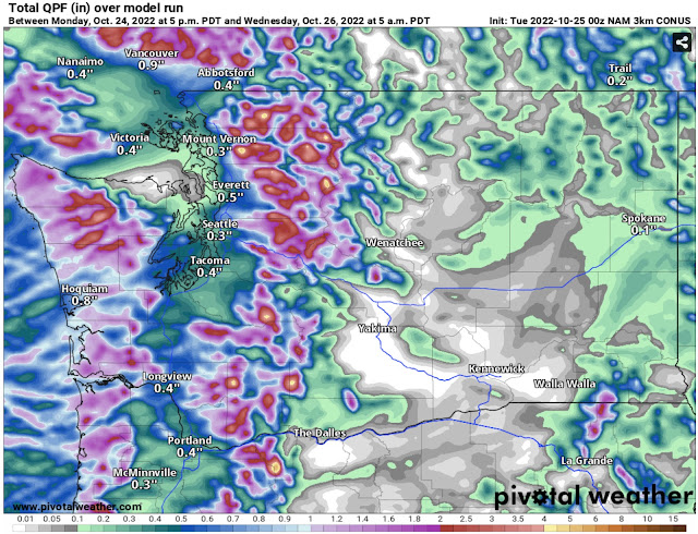
Let’s take a look at the rain forecast. The HRRR forecast is below, through 5 AM Wednesday.


The HRRR shows 0.3-0.6 inches of rain in the lowlands, with areas of 0.6-0.8 inches, mainly from Seattle southward and Everett to Arlington. The coast and mountains will receive 1-3 inches, and areas from Olympia southward will receive 0.75-1.1 inches.

Next, let’s compare this to the NAM model, also through 5 AM Wednesday.


The NAM shows a bit less rain in the lowlands, around 0.3-0.5 inches, with a potential Covergence Zone signature between Seattle and Everett showing up to 1.2 inches. The NAM brings 0.75-3 inches to the coast and mountains, but less (0.3-0.7 inches) from Olympia southward.

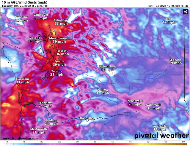
Another round of breezy conditions are also expected. Below is the HRRR forecast for 2 PM Tuesday.


The HRRR shows winds gusting 30-40 mph at peak in the Puget Sound area. This would be associated with frontal passage, which is expected at some time Tuesday afternoon or evening.

The NAM is a bit later and weaker with winds. The forecast at 5 PM Tuesday is below.


The NAM shows winds peaking around 5 PM, gusting 30-35 mph around the region. 

Although wind speeds aren’t very significant (30-40 mph), there is a slight chance of tree damage and power outages, so be prepared.

For the mountains, Tuesday’s system will bring another round of snow, mainly above 4,000 feet. The HRRR forecast through 5 AM Wednesday is below.


The HRRR is  more aggressive with snow, showing up to 8 inches at higher passes, with even higher amounts of 1-3 feet at the highest elevations (8,000+ feet).

The NAM model is less aggressive with snowfall on Tuesday, as seen below in the forecast through 5 AM Wednesday.


The NAM shows up to 6 inches at the higher passes and 1-2 feet of snow at 8,000+ feet. Both forecasts do show 2-12 inches of snow in the Olympic and Blue Mountains in addition to the Cascades.

Expect a break in the rain all day Wednesday and Thursday morning, before the next round of rain arrives midday Thursday. There is a chance for a round of rain overnight Wednesday. The extended signal is for above average precipitation through the beginning of November.

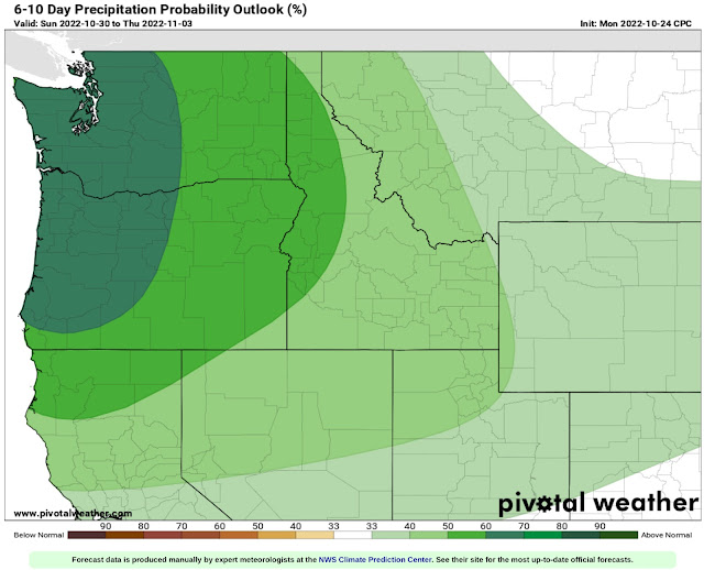
Below is the NWS Climate Prediction Center precipitation outlook for October 30 to November 3.


The CPC outlook shows a 60-70% probability of above average precipitation through the first few days of November. In short, active weather will continue into November, so stay tuned!

Sunday, October 23, 2022

Next System Bringing More Rain, Winds, and High Mountain Snow

FastCast—Monday, Oct. 24 to Wednesday, Oct. 26:

The next weather system arrives late Sunday night, bringing another round of rain, wind, and mountain snow (above 4,000 feet). Rain will total 0.2-0.4 inches in the lowlands, except for a rain shadow that could decrease totals around Seattle and the Central Kitsap Peninsula, with only 0.1-0.2 inches possible if the rain shadow verifies. With continuous onshore flow on Monday, Convergence Zone bands are possible across the Central Sound. Another element of this system will be winds. Frontal passage will be early Monday morning (3-7 AM). Expect the strongest winds (gusting up to 40-50 mph) on the coast and north of Everett. The interior lowlands will gust up to 25-35 mph, with stronger gusts up to 35-40 mph possible around Olympia and Tacoma. More mountain snow (2-12 inches) is expected above 4,000 feet. Some impacts are possible at Stevens and White Passes, on the North Cascades Highway, and on Chinook and Cayuse Passes. Another weather system will move through on Tuesday, with the same impacts expected, so stay tuned for more information. Wednesday will be a dry day between systems.

———————————————————

Continue reading the full blog below!

The next weather system is heading for Western Washington, bringing more rain, wind, and high mountain snow.

Let’s start with the rain. Below is the HRRR forecast for rain through 12 AM Tuesday.


The HRRR shows 0.2-0.3 inches in the lowlands, with a signal for a Convergence Zone east of Seattle, with up to 0.5 inches possible. The coast and mountains will receive 0.75-2.5 inches, with 0.4-0.9 inches from Mount Vernon northward and Olympia southward.

Now, let’s compare this with the NAM forecast (also through 12 AM Tuesday).


The NAM is quite similar, except with a more pronounced rain shadow effect in the Central Sound and more rain from Everett northward. The mountains and coast still receive around 0.6-2.5 inches.

Frontal passage early Monday morning will bring windy conditions to the area. While some locations will just be breezy, it will be our first decent winds of the season.

Let’s start with the HRRR forecast. 


Above is the forecast for 2 AM Monday, showing peak SE winds from Everett northward and on the coast, likely gusting 30-50 mph, strongest on Whidbey and the San Juans and in Whatcom County.

By 7 AM Monday (below), the front will be passing through the lowlands.

The HRRR shows winds gusting 30-40 mph from Everett southward to Olympia.

Now, let’s look at the NAM forecast, starting with 3 AM Monday (below).

This shows peak SE winds ahead of the front, which the NAM has a bit stronger than the HRRR, with gusts of 25-35 mph in the interior and 40-50 mph on the coast and north of Everett (good agreement with the HRRR).

This next frame is the NAM forecast for 4 AM, around the time of frontal passage.

The NAM shows winds gusting 30-40 mph around the interior, and 40-50 mph on the coast and north of Everett.

Regarding winds, the actual wind speeds don’t differ much between the HRRR and NAM. The only difference between the HRRR and NAM is the timing of the frontal passage, so expect the strongest winds around 4-7 AM. These winds are enough to cause slight tree damage and isolated power outages, especially with the leaves still on most trees.

More mountain snow is ahead as well, mainly above 4,000 feet. The NAM forecast is below, showing snow through 12 AM Tuesday.

Expect 2-12 inches above 4,000 feet, most on the mountain peaks. 

The HRRR forecast lines up with the NAM.

The HRRR also shows 2-12 inches above 4,000 feet.

With the snow level around 4,000 feet, winter driving conditions are possible at Stevens Pass, White Pass, the North Cascades Highway, and Chinook/Cayuse Passes.

While a wet and active week is expected this week (except Wednesday), the signal for above average precipitation is strong into the beginning of November. The NWS Climate Prediction Center outlook for October 29 to November 2 is below.

The CPC shows a 50-60% probability of above average precipitation.

This is backed up by the long-range forecast from the European model ensemble, showing total rain through the end of October.


Stay tuned for more information on Twitter and on the blog as this active pattern continues!

Thursday, October 20, 2022

First Storm of the Season Arrives Friday, Active Pattern Ahead

FastCast—Friday, Oct. 21 to Sunday, Oct. 23:

The first storm of the season is ahead for Western Washington! Air quality will drastically improve by Friday morning, with the entirety of Western Washington returning to the “good” category. Rain will begin Friday morning, continuing through midday Saturday. Rain will be heavy at times, and will total 0.5-0.9 inches in the lowlands. Some areas of lesser totals are possible if a rain shadow develops, likely between Hood Canal and Seattle should that happen. Regardless, this will be the first major rain event since June! Snow levels will crash to 4,000 feet, bringing 2-6 inches of snow to higher passes and recreation areas, mainly later Friday into Saturday. Sunday will be mostly cloudy and drier, with a break between weather systems (more rain, possible wind to start next week). Temperatures will be noticeably colder, with highs in the upper 40s to low 50s and lows dropping to the upper 30s to low 40s, our coldest temperatures since spring. Stay tuned for more information as this active pattern continues!

———————————————————

Continue reading the full blog below!

Rain is returning to Western Washington! The first significant system in months will arrive on Friday, bringing rain, mountain snow, and much cooler temperatures.

Let’s start with the rain. The high-resolution NAM forecast for rain through 5 PM Saturday is below.


The NAM forecast shows 0.7-1.1 inches of rain for Western Washington, with similar amounts on the coast and parts of Eastern Washington. The Cascades and Olympics will receive 1-4 inches. 

Let’s compare this to another high-resolution forecast, the HRRR (also through 5 PM Saturday).


The HRRR shows less rainfall for the Seattle area and more for Portland. However, it still gives the lowlands 0.5-0.9 inches, with less between Shoreline and SeaTac due to a rain shadow. 

It is a safe bet that the most rain since early summer is ahead. This will start the process of extinguishing the wildfires. However, it is important to remember that heavy rain over burn scars can produce deadly debris flows and mudslides. The threat for debris flows is highest near the Bolt Creek Fire burn scar.

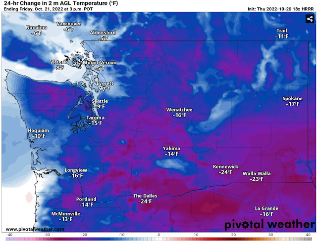
This system will also bring much cooler temperatures. The HRRR forecast below shows the difference between temperatures at 3 PM Thursday vs. 3 PM Friday.


Across the region, Friday will be 10-30 degrees colder than Thursday, with the biggest changes in Eastern Washington and Eastern Oregon. 

For the foreseeable future, highs will be in the upper 40s to low 50s, and lows will be in the upper 30s to low 40s. Essentially, Thursday morning’s lows will be close to Friday’s highs.

As expected, this huge decline in temperatures will bring a large drop in snow levels. By late Friday, snow levels will be around 4,000 feet. The HRRR forecast below shows expected snowfall (not necessarily what accumulates) through 5 PM Saturday.


With this system, snow will be confined to higher passes and recreation areas. In those places, expect 2-6 inches of snow to start the season!

Looking into the extended forecast outlooks from the NWS Climate Prediction Center, we can see a clear weather trend to end October. The temperature outlook for October 26-30 (middle of next week to last Sunday of October) is below.


This outlook calls for a 33-40% chance of below average temperatures, indicating that we will be near or slightly below normal (mid to upper 50s). 

The precipitation signal for the 26th-30th is stronger, as seen below.

The precipitation outlook calls for a 50-60% chance of above average precipitation through the end of the month. That is a positive sign considering the next graphic.

Below is the US Drought Monitor outlook, released today (October 20th).


All of Washington is in some kind of drought, and the Coast & Cascades have been upgraded to “severe drought,” while the rest of Western Washington remains in “moderate drought.”

To show why this drought will likely be removed within the next few weeks, take a look at the European model’s extended ensemble forecast showing rain through next Saturday (Oct. 29th).


The European model shows 2-3 inches of rain in the lowlands in the next 8 days. While a forecast this far out should never be taken at its word, it is a good indicator of what’s ahead.

Stay tuned to Twitter (click the Twitter icon on the right top of the blog) and to the blog for updates as active weather is expected through the end of October!

Thursday Morning Update: Smoke to Clear Slower Than Expected

This is a brief morning update to reflect the slower nature of the smoke clearing out of the Puget Sound area.

Below is the situation at 8 AM Thursday, from the HRRR smoke model.


Smoke is still engrained across most of Western Washington and most of Western Oregon.

AQI levels at 7:45 AM Thursday are relatively similar to Wednesday night, as seen in the Purple Air map below.


The reason that smoke is clearing slower than expected is due to a strong inversion. This inversion is what kept very unhealthy to hazardous air quality in place overnight.

Inversions keep out “mixing” of air, which keeps low level air fresh. As onshore flow begins Thursday, it will slowly erode the inversion that is in place over the lowlands, and the Central Sound (entire metro area) will be the last area to clear out.

Let’s time this out. 12 PM Thursday is below.


Notice that smoke is improving in the mountains, with plumes of smoke starting to move east. Surface smoke is still moderate to heavy in the Puget Sound area and Willamette Valley.

By 4 PM Thursday, there is further improvement.


Smoke has been pushed back to only cover areas between Olympia and Mount Vernon. Eastern Washington is dealing with bad AQI due to westerly flow.

At 8 PM Thursday, onshore flow has eroded smoke coverage significantly.


By nightfall, smoke will have mostly cleared from areas between Olympia and Tacoma, now only extending from Federal Way to Skagit County. Eastern Washington will be dealing with dense surface smoke from long plumes coming off fires in the Cascades.

The final image is for 12 AM Friday.


At this point, rain will be on our doorstep. At midnight, the lowlands are almost entirely clear of smoke, as well as the Willamette Valley. Conditions will remain poor overnight in Eastern Washington.

Overall, due to the inversion, it will take over 12 hours for smoke to totally clear out of Western Washington. However, by Friday, expect “good” air quality and our first significant rain since June! More on that tonight…

Next Storm System Hits Western Washington

  8-26 Video Briefing: Next Storm System Hits Western Washington