FastCast—Sunday, Oct. 30 to Tuesday, Nov. 1:
A much more robust atmospheric river is ahead for the Pacific Northwest from Sunday through late Monday (Halloween). Winds will increase on Sunday morning, gusting 25-35 mph around the region all day. Winds will be higher (35-45 mph) from Everett northward, on the coast, and along the water. Rain will spread slowly from north to south throughout Sunday, with initial rain shadowing for the Central Sound, before rain increases in the evening. Rain will continue through Monday, likely tapering to showers by Monday evening, so showers are possible for trick-or-treating around the area. Rain totals will be substantial, reaching 0.75-1.5 inches for the entire Puget Sound area, with a potential for totals up to 1.75-2 inches. Snow levels will skyrocket to 7,000-8,000 feet, bringing significant rain to the mountains. Amounts of 3-6 inches will fall in the mountains (1.5-2 inches in the foothills), and the coast will receive 1.5-3 inches. Rivers will rise significantly from their lingering summer levels, but river flooding is not expected, although some rivers will reach bankfull. The atmospheric river will bring warmer temperatures, with Sunday morning lows in the upper 40s and afternoon highs in the mid 50s. Tuesday will bring continued showers, but much cooler weather, with highs in the upper 40s and lows in the upper 30s to low 40s.
—————————————————————
Continue reading the full blog below!
The first significant atmospheric river of the season is ahead for Western Washington, bringing the biggest rainfall since late spring. The UW forecast below shows the atmospheric river aimed right at Western Washington late Sunday night.
The forecast above shows integrated water vapor transport, which is essentially the amount of water vapor in the atmosphere. Late Sunday night, a current of high water vapor values will be aimed right at Western Washington.
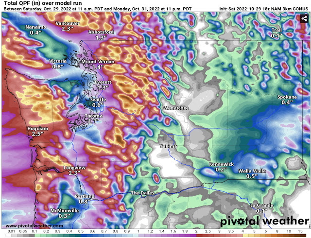
Let’s take a look at the rain totals. Below is the NAM model, representing the lower side of potential totals (through 11 PM Monday).
The NAM shows 0.5-1.5 inches of rain for the lowlands, with the most from Everett northward and the least in the rain shadow around Seattle and Bremerton and on the NE Olympic Peninsula. The coast and mountains pick up 2-6 inches, and even parts of Eastern Washington get 0.25-0.75 inches, with up to 1.25 inches south of Spokane!
Next is the HRRR forecast, which represents a wetter solution. This shows rain through 5 PM Monday, a bit earlier than the NAM forecast.
This forecast brings much more rain to the lowlands than the NAM forecast does, while lessening rain for the Willamette Valley and Eastern Washington. The lowlands will get drenched with 1-2 inches of rain, the most between Seattle and Tacoma. The foothills and areas from Olympia to Kelso will receive 1.5-3 inches, and the coast and mountains will be soaked by 3-6 inches.
With these forecasts showing the entire spectrum of possible rainfall, it is safe to expect amounts of around 0.8 to 1.5 inches for the lowlands.
Another element of this atmospheric river will be the winds, which will be strongest during the day Sunday. Note: gusts of 30-35 mph are expected during the Seahawks game on Sunday afternoon.
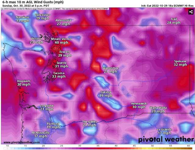
Below is the European model forecast for winds on Sunday afternoon.
The European model shows gusts of 30-35 mph around the lowlands and 35-40 mph north of Everett and on the coast. Winds will be strongest along the water.
Below is the NAM forecast for winds at 1 PM Sunday, showing a stronger solution (that is more unlikely).
The NAM forecast predicts winds around the entire region gusting up to 35-40 mph on Sunday afternoon.
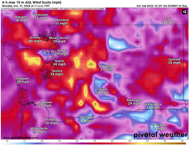
The European model forecast shows a secondary surge of winds early on Monday, seen below
This secondary wind surge may have gusts of 30-40 mph around the lowlands, with stronger gusts of 40-45 mph along the Strait of Juan de Fuca, on the coast, and in the mountains. Parts of Eastern Washington could have gusts of 30-40 mph as well.
One final note about this atmospheric river…snow levels will be very high. The influx of subtropical air from the atmospheric river will surge snow levels to 7,000-8,000 feet. The NAM forecast below shows snowfall through 11 PM Monday.
Snow accumulation will be very spotty except at higher elevations. However, the major mountain peaks may receive over 3 feet of snow!
Stay tuned for updates on Twitter and stay tuned to the blog for more updates as active weather continues!


No comments:
Post a Comment