FastCast—Friday, Oct. 21 to Sunday, Oct. 23:
The first storm of the season is ahead for Western Washington! Air quality will drastically improve by Friday morning, with the entirety of Western Washington returning to the “good” category. Rain will begin Friday morning, continuing through midday Saturday. Rain will be heavy at times, and will total 0.5-0.9 inches in the lowlands. Some areas of lesser totals are possible if a rain shadow develops, likely between Hood Canal and Seattle should that happen. Regardless, this will be the first major rain event since June! Snow levels will crash to 4,000 feet, bringing 2-6 inches of snow to higher passes and recreation areas, mainly later Friday into Saturday. Sunday will be mostly cloudy and drier, with a break between weather systems (more rain, possible wind to start next week). Temperatures will be noticeably colder, with highs in the upper 40s to low 50s and lows dropping to the upper 30s to low 40s, our coldest temperatures since spring. Stay tuned for more information as this active pattern continues!
———————————————————
Continue reading the full blog below!
Rain is returning to Western Washington! The first significant system in months will arrive on Friday, bringing rain, mountain snow, and much cooler temperatures.
Let’s start with the rain. The high-resolution NAM forecast for rain through 5 PM Saturday is below.
The NAM forecast shows 0.7-1.1 inches of rain for Western Washington, with similar amounts on the coast and parts of Eastern Washington. The Cascades and Olympics will receive 1-4 inches.
Let’s compare this to another high-resolution forecast, the HRRR (also through 5 PM Saturday).
The HRRR shows less rainfall for the Seattle area and more for Portland. However, it still gives the lowlands 0.5-0.9 inches, with less between Shoreline and SeaTac due to a rain shadow.
It is a safe bet that the most rain since early summer is ahead. This will start the process of extinguishing the wildfires. However, it is important to remember that heavy rain over burn scars can produce deadly debris flows and mudslides. The threat for debris flows is highest near the Bolt Creek Fire burn scar.
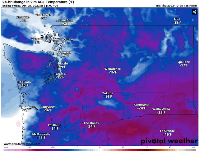
This system will also bring much cooler temperatures. The HRRR forecast below shows the difference between temperatures at 3 PM Thursday vs. 3 PM Friday.
Across the region, Friday will be 10-30 degrees colder than Thursday, with the biggest changes in Eastern Washington and Eastern Oregon.
For the foreseeable future, highs will be in the upper 40s to low 50s, and lows will be in the upper 30s to low 40s. Essentially, Thursday morning’s lows will be close to Friday’s highs.
As expected, this huge decline in temperatures will bring a large drop in snow levels. By late Friday, snow levels will be around 4,000 feet. The HRRR forecast below shows expected snowfall (not necessarily what accumulates) through 5 PM Saturday.
With this system, snow will be confined to higher passes and recreation areas. In those places, expect 2-6 inches of snow to start the season!
Looking into the extended forecast outlooks from the NWS Climate Prediction Center, we can see a clear weather trend to end October. The temperature outlook for October 26-30 (middle of next week to last Sunday of October) is below.
This outlook calls for a 33-40% chance of below average temperatures, indicating that we will be near or slightly below normal (mid to upper 50s).
The precipitation signal for the 26th-30th is stronger, as seen below.
The precipitation outlook calls for a 50-60% chance of above average precipitation through the end of the month. That is a positive sign considering the next graphic.Below is the US Drought Monitor outlook, released today (October 20th).
All of Washington is in some kind of drought, and the Coast & Cascades have been upgraded to “severe drought,” while the rest of Western Washington remains in “moderate drought.”
To show why this drought will likely be removed within the next few weeks, take a look at the European model’s extended ensemble forecast showing rain through next Saturday (Oct. 29th).
The European model shows 2-3 inches of rain in the lowlands in the next 8 days. While a forecast this far out should never be taken at its word, it is a good indicator of what’s ahead.
Stay tuned to Twitter (click the Twitter icon on the right top of the blog) and to the blog for updates as active weather is expected through the end of October!


No comments:
Post a Comment