FastCast—Tuesday, Oct. 25 to Thursday, Oct. 27:
Another system is ahead for Western Washington on Tuesday. This system will bring more rain than on Monday. Rain will start around noon, with showers lasting into the night. Expect 0.4-0.7 inches in the lowlands on Tuesday, with isolated spots getting less. There will be a rain shadow in the traditional area of the NE Olympic Peninsula. The coast and mountains will receive 1-3 inches of rain, and areas from Olympia southward have a chance to get over 0.8”. Additionally, Tuesday will be breezy, with winds gusting 20-30 mph around the area. Stronger winds, gusting up to 35-40 mph, are possible Tuesday afternoon/evening during frontal passage. Snow levels will again be around 4,000 feet, with 2-6 inches of new snow at the higher passes, and up to 12-24 inches on peaks over 8,000 feet. 2-12 inches of snow are also expected in the Olympics and Blue Mountains. Conditions will be drier on Wednesday, with highs in the low to mid 50s and lows in the low to mid 40s. There is a chance for a round of light rain on Wednesday night. Thursday will be dry in the morning, with the next round of rain arriving later in the day. Stay tuned!
———————————————————
Continue reading the full blog below!
Another weather system will impact Western Washington on Tuesday. This system will bring more rain than Monday’s system, with another round of breezy conditions and mountain snow.
Let’s take a look at the rain forecast. The HRRR forecast is below, through 5 AM Wednesday.
The HRRR shows 0.3-0.6 inches of rain in the lowlands, with areas of 0.6-0.8 inches, mainly from Seattle southward and Everett to Arlington. The coast and mountains will receive 1-3 inches, and areas from Olympia southward will receive 0.75-1.1 inches.
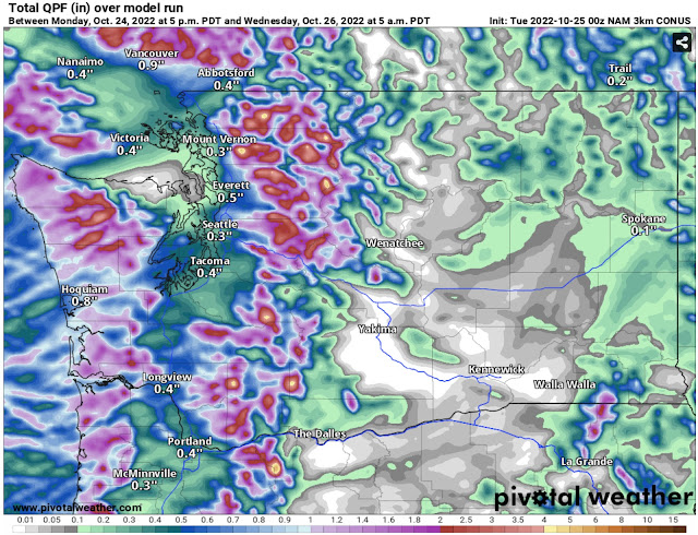
Next, let’s compare this to the NAM model, also through 5 AM Wednesday.
The NAM shows a bit less rain in the lowlands, around 0.3-0.5 inches, with a potential Covergence Zone signature between Seattle and Everett showing up to 1.2 inches. The NAM brings 0.75-3 inches to the coast and mountains, but less (0.3-0.7 inches) from Olympia southward.
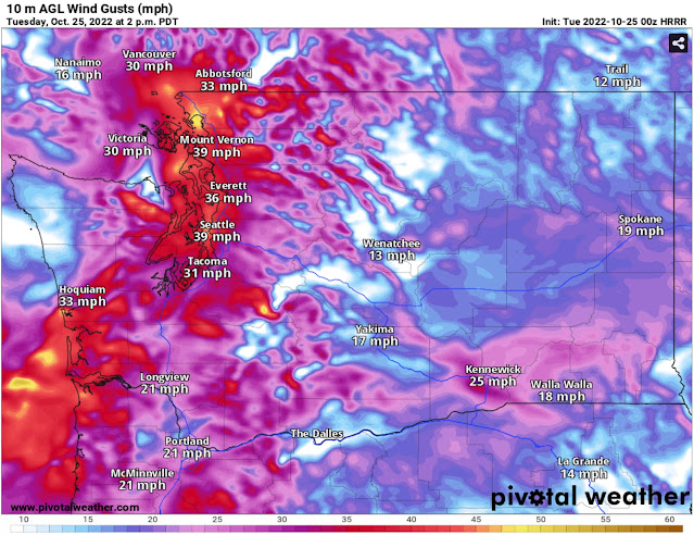
Another round of breezy conditions are also expected. Below is the HRRR forecast for 2 PM Tuesday.
The HRRR shows winds gusting 30-40 mph at peak in the Puget Sound area. This would be associated with frontal passage, which is expected at some time Tuesday afternoon or evening.
The NAM is a bit later and weaker with winds. The forecast at 5 PM Tuesday is below.
The NAM shows winds peaking around 5 PM, gusting 30-35 mph around the region.
The HRRR is more aggressive with snow, showing up to 8 inches at higher passes, with even higher amounts of 1-3 feet at the highest elevations (8,000+ feet).
The NAM shows up to 6 inches at the higher passes and 1-2 feet of snow at 8,000+ feet. Both forecasts do show 2-12 inches of snow in the Olympic and Blue Mountains in addition to the Cascades.


No comments:
Post a Comment