Tuesday, January 31, 2023

Calm Weather Through Friday, Then Active Weather Returns

 FastCast—Wednesday, Feb. 1 to Sunday, Feb. 5:

After a frigid Monday morning and some surprise light lowland snow on Tuesday morning, weather will remain cloudy and calm through late Thursday. Expect highs in the upper 40s to low 50s, with some potential sunbreaks. Morning lows will be slightly warmer than the past few days, reaching the low to mid 30s. Conditions change on Friday, as a system will bring showers and breezy winds gusting 25-35 mph (40-50 mph possible from Everett to the San Juans). 0.2-0.5 inches of rain is expected across the lowlands, with 0.5-1 inch on the coast. The passes will receive 4-10 inches of snow by late Friday. Some uncertainty remains with the details. More systems are expected through the weekend and into next week. Warmer temperatures are also expected starting Friday, with highs in the upper 40s to low 50s and lows in the low to mid 40s.

——————————————————

Continue reading the full blog below!

We are now in a relative break in interesting weather, as we transition from cold and light snow to a more typical rainy/breezy pattern later this week.

The general pattern change can be seen below in the NWS Climate Prediction Center outlook for February 6-10.


This outlook shows a 40-50% chance of above average precipitation for Western Washington through the first week of February, a change from the drier-than-normal conditions that dominated January.

How much rain is possible? The potential totals from the European model through the next week (ends Tues., Feb. 7) are below.


If the European model’s forecast verifies, the lowlands can expect 1-1.5 inches of rain from Friday onward, with 2-3 inches on the coast. 

Significant mountain snow is possible through the next week as well, but uncertainty is still high regarding amounts. As of the writing of this blog, anywhere from 1-3 feet is possible at the passes from Friday onward.

One more note…the surprise snow on Tuesday morning. This was due to precipitation from a weak front moving in while temperatures were around 30-32º. Was this in the forecast? Take a look at the European model’s forecast from early Tuesday morning.


The European model accurately showed light snowfall from near Tacoma northward to Vancouver BC. 

This was accurate, as seen in my photo from Federal Way on Tuesday morning.


Light snow covered most roofs, some side streets, and grassy surfaces. No more lowland snow is in the forecast for now, but those in the mountains should be prepared for quite a snowy first half of February.

Saturday, January 28, 2023

Brief Cold Snap Bringing Frigid Conditions

 FastCast—Sunday, Jan. 29 to Wednesday, Feb. 1:

A brief incursion of arctic air will bring very cold temperatures to the Pacific Northwest through Monday. Expect lows in the upper 20s on Sunday morning, potentially in the mid 20s for outlying areas. Brisk northeasterly winds will gust 20-30 mph around the Sound on Sunday, bringing wind chills in the mid 20s to low 30s. Highs will only reach the upper 30s to near 40 on Sunday and Monday. Monday morning will be the coldest, with lows in the lowlands reaching the low to mid 20s, and into the single digits in Eastern Washington. Conditions normalize on Tuesday, with cloudy conditions returning, highs the low to mid 40s, and lows in the mid 30s. 

———————————————————

Continue reading the full blog below!

A brief cold snap is ahead for Washington State, with the coldest temperatures on Monday morning. First off, expect lows in the mid to upper 20s on Sunday morning.

The coldest temperatures will be on Monday morning. Below is the European model forecast for Monday morning’s lows.


Expect lows in the low to mid 20s in Western Washington and in the upper single digits to upper teens in Eastern Washington.

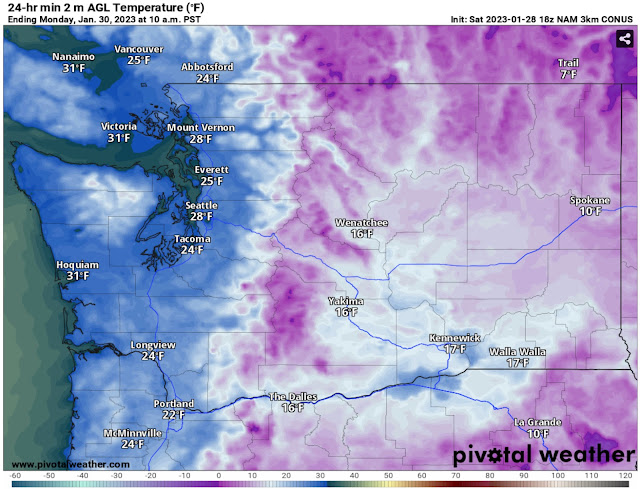
To verify this forecast, let’s take a look at the NAM high-resolution forecast for Monday morning’s lows, seen below.


The higher-resolution NAM forecast agrees with the European, showing lows in the mid 20s for Western Washington, except a bit higher near the water. Eastern Washington will drop to the upper single digits to mid teens. 

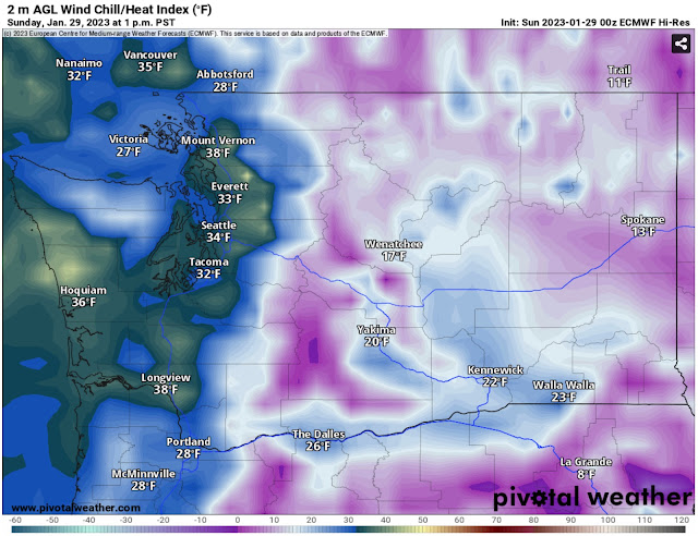
Another aspect of this cold snap will be the wind chill. Below is the wind chill at 1 PM Sunday, around the warmest time of the day.


At midday Sunday, wind chills will only be in the low to mid 30s in the lowlands and frigid-in the low teens to low 20s-in Eastern WA.

It will be even colder around 7 AM Monday, as seen in the European model wind chill forecast below.


On Monday morning, expect lowland wind chills in the mid teens to low 20s. Eastern Washington will be frigid, with wind chills in the -5º to +15º range.

Remember, even though this is a brief cold snap, make sure to take precautions, protecting pets, plants, pipes, and keeping yourself warm!


Thursday, January 26, 2023

Large Weather Swing Ahead

 FastCast—Friday, Jan. 27 to Tuesday, Jan. 31:

After a very persistent high pressure ridge kept clouds and calm conditions in place most of the week, a change is ahead. Rain is expected at times through late Saturday, most from Seattle northward to Skagit County. For those areas, expect 0.4-1 inch of rain. Outside those areas, expect 0.1-0.3 inches. Snow will fall in the mountains as well, most from Thursday night to midday Friday and then on Saturday. At the passes, expect totals of 8-12 inches, with some impacts possible. Conditions will rapidly clear and dry out late Saturday night into Sunday morning, with temperatures dropping from the low 40s to the upper 20s. Brisk northeasterly winds will bring wind chills in the teens on Sunday and Monday. Monday morning’s lows will be in the upper teens to low 20s across the lowlands, before temperatures begin warming back up, with lows in the upper 20s to low 30s on Tuesday morning. Overall, expect highs in the mid to upper 40s on Thursday and Friday, with lows in the upper 30s to low 40s. Saturday is the transition, with highs in the low to mid 40s changing to lows in the upper 20s by Sunday morning. On Sunday and Monday, expect mostly sunny conditions with highs in the mid to upper 30s and lows in the upper teens to low 20s. 

————————————————————

Continue reading the full blog below!

After a very persistent high pressure ridge dominated weather this week, a significant swing is ahead over the coming days.

This will start with a couple weak systems bringing rain and mountain snow through Saturday night, before high pressure builds east of the Rockies, pushing frigid air into the Pacific Northwest. 

Below is the European model forecast for rain through Saturday night.


Expect 0.4-1 inch from Seattle northward to Skagit County. From Seattle southward and on the coast, expect 0.1-0.4 inches. This odd distribution of precipitation is due to the weak nature of these systems and the northwesterly angle they’re arriving from.

Next, take a look at the European model forecast for total snow through Saturday night.


Expect 8-12 inches in the passes through Saturday night, with 1-3 inches for Spokane and 0.2-1 inch for Wenatchee and Yakima. Travel impacts are possible in the passes, with the most snow expected from late Thursday to midday Friday and on Saturday.

Then, on Saturday night, a big change occurs. Surface high pressure will build east of the Rockies, ushering in arctic air to the Pacific Northwest. Below is the European model upper-air map for late Saturday.


Notice the green arrows, showing the arctic air moving in from the interior of Canada. This means that it is very dry, ending any chance of lowland snow this weekend.

How cold will it get? There will be a significant decrease in temperatures from Saturday morning to Sunday morning, as seen in the European model forecast below.


This forecast shows that temperatures at 7 AM Sunday will be 10-20 degrees colder in Western Washington and 15-25 degrees colder in Eastern Washington than they were at 7 AM Saturday.

As of now, the coldest temperatures are expected to be on Monday morning. The European model forecast below shows Monday morning’s lows.


Expect very cold temperatures in the upper teens to low 20s for the lowlands, except in the mid 20s near the water. Eastern Washington will be even colder, with lows of zero to the mid teens expected. 

I will have another update on the cold by Saturday evening. Stay tuned!

Tuesday, January 24, 2023

Strong High Pressure Ridge, Cold Arctic Air Ahead

 FastCast—Wednesday, Jan. 25 to Monday, Jan. 30:

A very strong high pressure ridge is dominating weather for the Pacific Northwest, and it is expected to continue influencing our weather for the next few days. The highest pressure in recent years (30.68-30.75”) will impact the region on Wednesday. Expect overcast conditions through Saturday. Weak systems sliding across the northern boundary of the ridge will bring 0.2-0.5 inches of rain through Saturday night, except 0.75-1.25 inches from Seattle northward. Highs will be in the mid to upper 40s, with lows in the upper 30s to low 40s. A significant change is expected on Sunday. The ridge will retrograde north to Alaska, opening up a cold air conduit for Arctic air to enter the Northwest. Conditions will clear up and temperatures will be noticeably colder. Brisk northeasterly winds will bring cold wind chills, and the air will be much drier. From Sunday to Monday, expect mostly sunny conditions with highs in the mid 30s to around 40º, and frigid lows in the low to mid 20s for the lowlands, and potentially in the upper teens for the foothills and outlying areas. Eastern Washington will likely drop into the 5 below to 10 above range. Stay tuned for updates over the next few days.

————————————————————

Continue reading the full blog below!

A large ridge of high pressure is dominating weather across the Pacific Northwest, bringing the highest atmospheric pressure in years (which will negate king tides). Below is the European model forecast showing the ridge (green box) late Wednesday.


The ridge will dominate weather at upper and lower levels of the atmosphere (it’s smaller at lower levels). However, since Western Washington is on the northern edge of the lower-level ridge, some weak systems will make their way over the ridge and bring showers to the region from Thursday to Saturday.

Below is the European model, showing rain through Saturday night.


Expect the most rain (0.75-1.25 inches) from Seattle northward, as the angle of these systems causes rain shadowing over the South/Central Sound. For areas from Seattle southward, expect 0.2-0.5 inches of rain. The coast will pick up 0.3-0.5 inches.

These weak systems will bring snow to the mountains, especially on Friday. Below is the European model forecast for total snow through Saturday night.


Delays will be possible if you’re crossing the mountain passes. Expect 6-10 inches at the passes through Saturday. Additionally, areas from Ritzville eastward in Eastern WA will pick up 1-4 inches of snow.

From late Saturday into Sunday, a big change will take place. Below is the European model upper-air forecast for late Saturday.


Notice that the ridge has gotten much larger and moved away from the Pacific Northwest. Its new position allows arctic air to enter into the region, as seen in the dark blue/purple colors (a trough, opposite of a ridge) that are over our region.

This will bring significantly colder temperatures, especially in the mornings. The European model forecast for Monday morning’s lows is below.


The European model shows very cold temperatures for the entire region. The entirety of Western Washington has a good possibility of dropping into the upper teens to low 20s, with brutally cold temperatures in the 5 below to 10 above range for Eastern Washington and the Cascades.

This overall pattern change can be seen in the NWS Climate Prediction Center outlook for temperatures from January 30th to February 3rd.


Wow. This outlook shows a 70-90% probability of below average temperatures for January 30th-February 3rd. Percentages this high usually indicate that it’s fairly certain that we will have cold temperatures.

Stay tuned for more information as this cold pattern continues to evolve. Next blog on Thursday night!

Friday, January 20, 2023

Saturday Storm: Winds & Mountain Snow

FastCast—Saturday, Jan. 21 to Wednesday, Jan. 25:

One day of active weather is ahead on Saturday, with a big change to a more stagnant and calm pattern next week. There is discrepancy on the Saturday storm, with some forecasts showing a fast-developing storm and others aren’t. If the storm develops, gusts could reach 50-60 mph on the coast, 40-50 mph along the Strait, and 30-40 mph in the lowlands. Stay tuned to Twitter for updates. Should winds develop, the combination of winds and king tides could produce coastal flooding and beach erosion in prone areas, especially on the coast. The precipitation on Saturday will arrive with chilly temperatures in the upper 20s to low 30s, so some higher hills may receive some brief snowflakes. The lowlands will receive 0.2-0.4 inches of rain on Saturday, and the Cascades will receive 6-10 inches of snow through Sunday night. Strong high pressure ridging will build on Sunday, continuing through next week. Partly to mostly cloudy conditions, with a chance of fog, will prevail. Highs will reach the mid to upper 40s, with lows in the upper 20s in outlying areas to the low to mid 30s in the remainder of the lowlands. 

———————————————————

Continue reading the full blog below!

A complex forecast situation is unfolding for Saturday. The European model shows a rapidly-developing low center that will bring a narrow tongue of strong winds (called a bent-back occlusion) to the Washington Coast on Saturday afternoon. This is shown below.


The forecast above is for 1 PM Saturday. The low center moves in around Copalis Beach, with strong winds for the Central and Southern WA Coast. The European model is more aggressive with this storm than other forecasts are, but historically, it’s the most accurate.

What about wind gusts? Below is the European model forecast for peak gusts on Saturday afternoon.


The European model shows peak gusts on the coast reaching 50-65 mph, with 25-45 mph gusts in the lowlands, strongest from SeaTac south and from Everett north.

Some other forecasts show winds, but a bit different. The NAM high-res forecast is below, showing winds at 5 PM Saturday.


The NAM shows gusts peaking at 30-45 mph region-wide, except 50-55 mph along the Strait. 

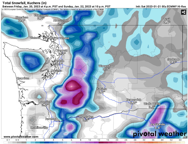
There will also be mountain snow with this system, as seen in the European model forecast below for snow through 10 PM Sunday.


The European model shows 6-10 inches of snow at Snoqualmie & White Passes, and 4-6 inches at Stevens Pass. Notice that lower elevations of Eastern Washington could receive 0.2-1.5 inches. 

Also notice the SLIGHT chance of brief snow for parts of the lowlands at the onset of precipitation on Saturday morning. That is due to the cold morning temperatures that will still be in place as precipitation arrives.


Lows in the lowlands will reach the low 30s, with Eastern Washington down to the mid teens to mid 20s. Light snow is much more likely for Eastern WA than the lowlands, with brief rain/snow mix being the most likely potential before changing to rain.


Monday, January 16, 2023

Showers Through Wednesday, Drier Late Week

 FastCast—Tuesday, Jan. 17 to Saturday, Jan. 21:

A system will bring a chance of rain to Western Washington from late Tuesday through Wednesday afternoon. Expect 0.2-0.4 inches for most of the lowlands, except up to 0.5-0.8 inches under the Convergence Zone band that will set up Wednesday afternoon. The coast will pick up 1-2 inches of rain, with 0.1-0.3 inches in Eastern Washington. Models differ on where this will be, but likely somewhere from Tacoma to Everett. Snow levels will be around 2,500 feet, so expect 4-8 inches of new snow at the passes, most on Wednesday. Persistent ridging will develop by Thursday, bringing a shift to drier and cooler weather, with a chance of showers late Friday to early Saturday. Expect highs in the mid to upper 40s and lows in the upper 30s (dropping to the low to mid 30s by Thursday morning). 

————————————————————

Continue reading the full blog below!

A couple rounds of rain will move through Western Washington from Tuesday evening to late Wednesday. There is some discrepancy in the models on how much rain will fall in total. Below is the latest European model, showing total rain through Wednesday night.


The European model shows 0.5-1.1 inches of rain for the lowlands, with the most between Tacoma and Everett due to a Convergence Zone band. The coast will receive 1.25-2.5 inches. Eastern Washington will get 0.2-0.3 inches, most north of I-90, and SW WA/Willamette Valley could get up to 0.75-1 inch of rain.

Now to see the other potential for this system. Below is the NAM high-resolution forecast showing total rain through early Thursday morning.


The NAM shows a different solution, with 0.2-0.5 inches for most of the lowlands, and the Convergence Zone band setting up between Seattle and Mount Vernon, giving those areas 0.5-0.8 inches of rain. The coast will get 0.8-2.5 inches of rain. Eastern Washington will get 0.1-0.25 inches.

This system will have snow levels from 2,000-2,500 feet, so impacts are expected on the passes. Below is the European model forecast for snow through Thursday afternoon (lingering showers possible in the mountains).


Expect 6-10 inches at the passes, with up to 12 inches at higher elevation recreation areas. Some parts of Eastern Washington will receive a trace to 2 inches of snow.

A pattern change is ahead, as seen in the NWS Climate Prediction Center outlook for temperature from January 24-30.


This outlook shows a 50-70% probability of below average temperatures across the Pacific Northwest in late January.

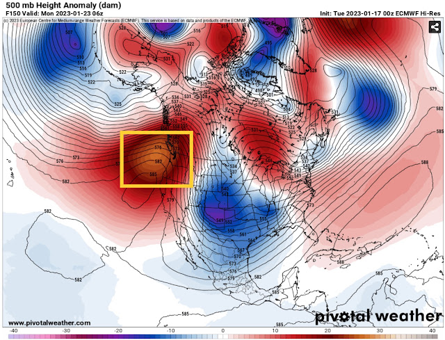
This will be caused by persistent ridging over the Pacific Northwest and British Columbia, seen in the yellow box below in the European model forecast for Sunday night.


This ridging deflects most weather systems from the region and brings calm weather that is usually cooler than average. This will also bring a much-needed long stretch of calmer weather for California.

Friday, January 13, 2023

Seahawks Playoff Forecast: Very Wet Field Expected

On Saturday at 1:30 PM in Santa Clara, California, the Seahawks will play the 49ers in the Wild Card Round of the NFL playoffs…and weatherwise, it’ll feel more like Seattle than California.

This blog will give a forecast for game time and the conditions prior to the game. Conditions prior to the game are important because Levi’s Stadium in Santa Clara has a true grass field, which will get quickly saturated with heavy rain.

This is different than Lumen Field in Seattle, which has a turf field that will get slippery but not super wet & muddy in rain.

Let’s start with the rain forecast. Below is the HRRR forecast for rain through 7 PM Saturday.


The value for San Jose is very close to Santa Clara. A strong front will move through before the game begins, with 0.4-0.7 inches of rain in a few hours and winds gusting 30-45 mph. Another 0.1-0.3 inches is possible in post-frontal showers during the game.

The high-resolution NAM forecast agrees with the HRRR on the rainfall through 7 PM Saturday.


The NAM agrees, with 0.4-0.8 inches of rain at Levi’s Stadium.

With a consensus of 0.4-0.9 inches of rain prior to kickoff and the potential for brief heavy showers during the game, it is likely that the grass field will be in poor condition prior to the game.

During the game, after the front has gone by, there is a chance of brief heavy showers and a slight chance of thunderstorms in those heavy showers. Below is the NWS Storm Prediction Center thunderstorm outlook for Saturday.


There is a chance of thunderstorms for most of Central and Northern California on Saturday. 

So…expect a very wet field, in-game showers and winds gusting 15-25 mph, and even a slight chance of thunderstorms for the Seahawks game on Saturday. Go Hawks!

Wednesday, January 11, 2023

Atmospheric River Ahead for Western Washington

 FastCast—Thursday, Jan. 11 to Saturday, Jan. 14:

An atmospheric river is ahead for Western Washington, with rain expected through Friday, turning to showers on Saturday. In the lowlands, expect 0.5-1.5 inches, with higher amounts of up to 2 inches in the foothills. The coast will receive 2-3 inches, and with snow levels near 6,000-7,000 feet, the mountains will receive 3-7 inches of rain. Eastern Washington will receive 0.2-0.5 inches of rain, with higher amounts near the Cascades. Winds will be breezy at times through Friday, especially easterly winds near the Cascade Foothills. Gusts of 30-40 mph are possible, especially from Enumclaw to North Bend. Winds gusting 25-40 mph are possible area-wide on Friday. Due to high soil moisture and successive rainfall, there is an increased threat of landslides in Western Washington. This threat will be highest in the mountains and foothills, but use caution around prone hillsides. Additionally, rivers will rise, but the only river that will flood is the Skokomish River on the SW Olympic Peninsula.

————————————————————

Continue reading the full blog below!

An atmospheric river (narrow current of significant, deep moisture) is ahead for Western Washington from early Thursday to late Friday. In the UW forecast below, the narrow current of moisture is seen paralleling the coastline and moving inland, at around 10 AM Thursday.


This is an interesting path for an atmospheric river, and the highest precipitation will be found (again) over Central/Northern California and Southern Oregon. 

However, the rain will definitely be noticeable in Western Washington. Below is the European model forecast showing rain through Friday night.


The European model shows 0.8-1.5 inches of rain for the lowlands, except 0.4-0.6 inches in the NE Olympics Rainshadow. The coast will get 2-3 inches and the mountains will get 3-5 inches. Eastern Washington will pick up 0.2-1 inch in this forecast, with the most near the Cascades.

Let’s take a look at some higher-resolution forecasts, starting with the NAM model, showing rain through 11 PM Friday.


The NAM forecast shows 0.9-1.25 inches in the lowlands, 2-4 inches on the Kitsap Peninsula, 1.5-3 inches on the coast, and 4-10 inches in the mountains. This shows less for Eastern Washington, at 0.2-0.5 inches.

Finally, the NWS NBM forecast, through 10 PM Friday.


The NWS NBM forecast agrees with the NAM and European, showing 0.75-1.25 inches of rain for the lowlands with the exception of the rainshadow. The coast and Kitsap Peninsula get 1.5-3 inches, and the mountains get 3-6 inches. Eastern Washington will pick up 0.1-0.5 inches, with more possible in the North Cascades.

Stay tuned! More active weather is ahead in the coming days.


Monday, January 9, 2023

Sunny Tuesday, Atmospheric River Late Week

FastCast—Tuesday, Jan. 10 to Friday, Jan. 13:

After a windy and rainy day on Monday, we will have a weather break on Tuesday, with partly to mostly sunny conditions and highs in the low to mid 50s! That will change on Wednesday, with clouds increasing and rain arriving by evening. An atmospheric river will impact Western Washington from late Wednesday through late Friday. This will bring 1.25-2 inches of rain to the lowlands, 2.5-3.5 inches on the coast/in the mountains, and 0.25-1.25 inches in Eastern Washington, with the most north of I-90. Area rivers will rise, but not to flooding levels at this point. Areas near the foothills will be impacted by gap winds gusting 30-40 mph at times on Tuesday and Wednesday. Expect highs in the low to mid 50s and lows in the upper 30s to mid 40s. 

———————————————————

Continue reading the full blog below!

Monday was an active day across Western Washington, with strong winds and heavy rain at times, and even some thunderstorms on the coast and briefly in the Bothell area. There’s more about Monday at the end of the blog.

Tuesday will be a great break in the activity, with partly to mostly sunny conditions and highs in the low to mid 50s! How long has it been since we had a sunny day?!? The European model forecast is below, showing Tuesday’s highs.


Expect highs in the low to mid 50s for most of Western Washington! Eastern Washington will be stuck with colder temperatures, with highs only in the mid 30s to low 40s.

However, that will all change by late Wednesday. An atmospheric river is expected to impact Western Washington from late Wednesday through late Friday. In the European model forecast below, you can see the atmospheric river paralleling the Pacific Coast on Thursday. This forecast shows precipitable water, another way of saying the amount of water in the atmosphere.


This will be a big rain-maker for areas from California all the way into Southern British Columbia, and will bring higher rain totals to Western Washington than the previous storms that have only been clipping the region.

Below is the European model for total rainfall through Friday night. Note: 0.2-0.5 inches of this has already fallen across the region, since the forecast shown started Monday morning.


Factoring in rain that has already fallen, the European model shows 1.25-2 inches of rain for the lowlands, 2-3.5 inches for the coast and mountains, and 0.25-1.25 inches in Eastern Washington, most from I-90 northward.

Stay tuned for more information about this atmospheric river in Wednesday’s blog.

—————————————————

Strong winds were the biggest impact of an interesting storm on Monday. A large low pressure system offshore spawned a small “spin-off low” that sucked winds out of the gaps in the Cascades and then produced 50-80 mph gusts on the coast. Below are peak gap winds in the metro area, mainly from Seattle south.


Locations prone to gap winds, such as Enumclaw, North Bend, and Sea-Tac Airport, gusted 45-55 mph.

This quick shot of strong gap winds brought a significant amount of power outages in the Puget Sound Energy service area, peaking with over 25,000 customers in the dark around midday. The Puget Sound Energy outage map from midday Monday is below.


The area from Enumclaw to Kent’s East Hill got hit the hardest, as did Sammamish and Issaquah. Why so many power outages for a few hours of winds? Gap winds come from the east, the opposite direction of the dominant S-SW winds typical to our region. This makes trees less resistant to these winds, causing more tree damage, and in turn, more power outages.

Thursday, January 5, 2023

Unsettled in the Northwest, Dangerous Weather in California

FastCast—Friday, Jan. 6 to Sunday, Jan. 8:

While the active storm track deflects south to California, Western Washington will get clipped by systems as they move north and weaken. Through Sunday, expect a chance of showers each day. The lowlands will receive 0.5-0.9 inches of rain through Sunday night, with 2-3 inches on the coast, and 0.1-0.5 inches in Eastern Washington. The passes will receive 4-10 inches of snow through Sunday, with more rain and snow next week for the region. Highs will be in the upper 40s to low 50s, with lows in the upper 30s to mid 40s. A quick note on Wednesday & Thursday: Warm downslope winds brought 20K+ power outages, gusts of 40-60 mph in the foothills, and skyrocketed temperatures to the upper 50s to low 60s, quite abnormal for this time of year. We won’t have temperatures in this range for the foreseeable future. An update on the California rain is below, and for more information about the constant storm train for California, check out Pacific Northwest Weather Watch YouTube channel, linked on the right under “Helpful Weather Websites.”

——————————————————————

Continue reading the full blog below!

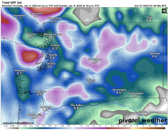
With the jet stream and storm track aimed directly at California, Western Washington will only get clipped by weakening systems through the next few days. Let’s take a look at the European model forecast for rain through Sunday night.


The European model shows 0.6-1 inch of rain for the lowlands (isolated higher amounts possible), with 2-3 inches on the coast and 0.1-0.5” for Eastern WA.

Next, the GFS (American) forecast, also showing rain through Sunday night.


The GFS shows less rain overall, with 0.5-0.75 inches for the lowlands and 0.3-0.9 inches on the coast. However, the GFS gives more rain to Eastern Washington, with 0.5-1.25 inches rain possible.

Before we switch gears to the very impactful California storm, let’s take a look at the European model snow forecast through Sunday night.


The European model shows 6-10 inches of snow at the passes through Sunday night, and 1-6 inches for communities on the eastern slopes of the Cascades, including Wenatchee, Leavenworth, and Ellensburg.

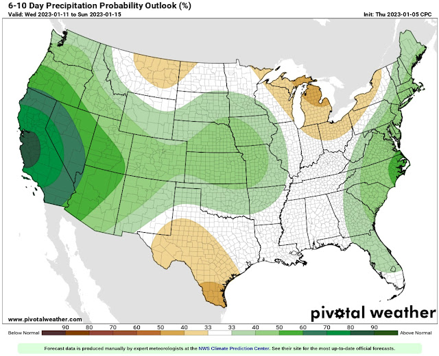
Now, let’s take a look at the overall extended outlook for rainfall. Below is the NWS Climate Prediction Center rainfall outlook from January 11-15.


The CPC outlook shows a 80-90% probability of above average rainfall centered on Central California, with 60-80% probabilities of above average rain for the rest of California and 33-50% above average for the rest of the West.

So how much rain will fall? Let’s take a look at the European model forecast through next Sunday morning (Jan. 15th).


The European model shows incredible rain amounts for Northern California…the bullseye of this pattern. San Francisco and Sacramento get 6-8 inches, with areas north of Sacramento getting an incredible 9-12 inches of rain in just over 10 days.

Next, the American GFS model, also showing total rain through the morning of Sunday the 15th.


The GFS paints a very similar picture, with amounts of 6-10 inches expected for all of Northern California.

The bottom line is that rainfall alone will cause dangerous and likely devastating flooding and landslides across the northern half of California. Successive storms will also bring rounds of strong winds, dangerous surf conditions, and incredible snow of 3-6 FEET in the Sierra Nevada. It looks like all kinds of impactful & dangerous weather are ahead for California in the coming weeks.

Tuesday, January 3, 2023

Bomb Cyclone Offshore Bringing Easterly Winds, Large Waves

 FastCast—Wednesday, Jan. 4 to Saturday, Jan. 7:

A massive bomb cyclone (called this due to its rapid strengthening) has developed offshore off the Pacific Northwest, which will bring significant impacts to Southern Oregon and most of California over the next few days. While staying far offshore from Washington, the storm will make its presence known with strong gap winds and large waves on the coast. Due to the storm’s strength, it will create a strong cross-Cascade pressure gradient, which will cause easterly winds to accelerate through the gaps in the Cascades, along the Western Strait, along the coast, and in the Chehalis Gap (follows SR-8 between Olympia and Aberdeen). The strongest gap winds will be in the Cascade foothills, Western Strait, and Coast, with winds gusting 40-55 mph. Gap winds will be strongest from midday Wednesday through early Thursday morning. Areas outside favored locations, most likely areas from Tacoma to Mount Vernon, could see SE gusts of 25-35 mph. Additionally, the common outflow spots of the Fraser River Valley and Columbia River Gorge will have gusty winds, likely 25-40 mph in the Fraser Valley and 30-60 mph in the Gorge. 0.5-0.75 inches of rain are expected across the lowlands through Saturday, with most rain falling on Thursday and Friday. The coast will receive 1-2 inches of rain, and the passes will receive 2-8 inches of snow. Highs will be in the upper 40s to low 50s, and lows will be in the low to mid 40s.

————————————————————

Continue reading the full blog below!

A massive storm (seen on the NOAA GOES Satellite Image below) is swirling offshore of the West Coast.


This storm, classified as a bomb cyclone due to its rapid strengthening, will bring significant wind and rain to California and Southern Oregon. While still far away from Western Washington, the storm’s strength will draw winds out of the gaps in the Cascades, producing easterly winds. The storm will also bring high surf to the entire coast.

Below is the UW forecast showing this massive and very deep storm at 7 AM Wednesday.


The storm is clearly visible off the Oregon/California border. It will deepen to around 955-960 millibars, an incredibly strong, likely hurricane-force storm.

With such low pressure over the Pacific Ocean and much higher pressure inland, this storm will create a strong cross-Cascade pressure gradient, driving increased east winds.

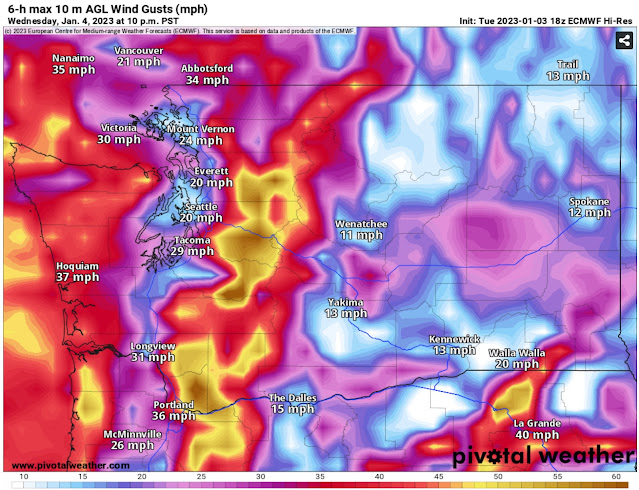
Below is the European model forecast for peak winds Wednesday evening.


The European model shows gusts of 40-50 mph in the foothills, 20-30 mph in the lowlands, and 35-45 mph for the Strait & Coast.

Next, the higher-resolution NAM forecast, showing peak winds around 6 PM Wednesday.


The NAM shows stronger winds, gusting 50-60 mph in the foothills, 30-40 mph from Tacoma northward, and 40-50 mph for the Coast, Strait, and areas west of the Columbia River Gorge.

Finally, the HRRR high-resolution forecast, also showing peak winds around 7 PM Wednesday.


The HRRR sides more with the European model, showing peak gusts in the foothills of 40-50 mph, 25-35 mph in the lowlands from Tacoma north, and 40-50 mph for the Coast, Strait, and areas west of the Gorge.

This storm will also bring massive swells to most of the US West Coast. Below is the European model forecast from Windy.com showing wave height Thursday evening.


By Thursday evening, the storm will be weakening and moving north, but massive waves of 20-35 feet will impact the coast from Southern California to Vancouver Island. The highest waves are expected from Central California to Central Oregon.

Finally, the first rounds of rain of 2023 for Western Washington are expected Thursday and Friday as this storm and its associated fronts move through. Below is the European model showing total rain through Friday night.


Expect 0.5-0.75 inches in the lowlands, with less in a potential Olympic Rain Shadow. The coast will pick up 1-2 inches, and SW WA/Willamette Valley will get 0.75-1 inch. Additionally, the passes will likely receive 2-8 inches of new snow.

Stay tuned, as there are no signs of an overall active pattern ending anytime soon.

Next Storm System Hits Western Washington

  8-26 Video Briefing: Next Storm System Hits Western Washington