FastCast—Tuesday, Jan. 17 to Saturday, Jan. 21:
A system will bring a chance of rain to Western Washington from late Tuesday through Wednesday afternoon. Expect 0.2-0.4 inches for most of the lowlands, except up to 0.5-0.8 inches under the Convergence Zone band that will set up Wednesday afternoon. The coast will pick up 1-2 inches of rain, with 0.1-0.3 inches in Eastern Washington. Models differ on where this will be, but likely somewhere from Tacoma to Everett. Snow levels will be around 2,500 feet, so expect 4-8 inches of new snow at the passes, most on Wednesday. Persistent ridging will develop by Thursday, bringing a shift to drier and cooler weather, with a chance of showers late Friday to early Saturday. Expect highs in the mid to upper 40s and lows in the upper 30s (dropping to the low to mid 30s by Thursday morning).
————————————————————
Continue reading the full blog below!
A couple rounds of rain will move through Western Washington from Tuesday evening to late Wednesday. There is some discrepancy in the models on how much rain will fall in total. Below is the latest European model, showing total rain through Wednesday night.
The European model shows 0.5-1.1 inches of rain for the lowlands, with the most between Tacoma and Everett due to a Convergence Zone band. The coast will receive 1.25-2.5 inches. Eastern Washington will get 0.2-0.3 inches, most north of I-90, and SW WA/Willamette Valley could get up to 0.75-1 inch of rain.
Now to see the other potential for this system. Below is the NAM high-resolution forecast showing total rain through early Thursday morning.
The NAM shows a different solution, with 0.2-0.5 inches for most of the lowlands, and the Convergence Zone band setting up between Seattle and Mount Vernon, giving those areas 0.5-0.8 inches of rain. The coast will get 0.8-2.5 inches of rain. Eastern Washington will get 0.1-0.25 inches.
This system will have snow levels from 2,000-2,500 feet, so impacts are expected on the passes. Below is the European model forecast for snow through Thursday afternoon (lingering showers possible in the mountains).
Expect 6-10 inches at the passes, with up to 12 inches at higher elevation recreation areas. Some parts of Eastern Washington will receive a trace to 2 inches of snow.
A pattern change is ahead, as seen in the NWS Climate Prediction Center outlook for temperature from January 24-30.
This outlook shows a 50-70% probability of below average temperatures across the Pacific Northwest in late January.
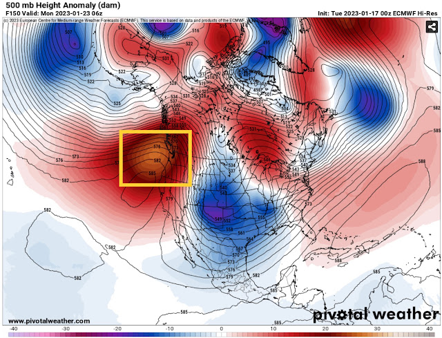
This will be caused by persistent ridging over the Pacific Northwest and British Columbia, seen in the yellow box below in the European model forecast for Sunday night.
This ridging deflects most weather systems from the region and brings calm weather that is usually cooler than average. This will also bring a much-needed long stretch of calmer weather for California.


No comments:
Post a Comment