FastCast—Friday, Jan. 6 to Sunday, Jan. 8:
While the active storm track deflects south to California, Western Washington will get clipped by systems as they move north and weaken. Through Sunday, expect a chance of showers each day. The lowlands will receive 0.5-0.9 inches of rain through Sunday night, with 2-3 inches on the coast, and 0.1-0.5 inches in Eastern Washington. The passes will receive 4-10 inches of snow through Sunday, with more rain and snow next week for the region. Highs will be in the upper 40s to low 50s, with lows in the upper 30s to mid 40s. A quick note on Wednesday & Thursday: Warm downslope winds brought 20K+ power outages, gusts of 40-60 mph in the foothills, and skyrocketed temperatures to the upper 50s to low 60s, quite abnormal for this time of year. We won’t have temperatures in this range for the foreseeable future. An update on the California rain is below, and for more information about the constant storm train for California, check out Pacific Northwest Weather Watch YouTube channel, linked on the right under “Helpful Weather Websites.”
——————————————————————
Continue reading the full blog below!
With the jet stream and storm track aimed directly at California, Western Washington will only get clipped by weakening systems through the next few days. Let’s take a look at the European model forecast for rain through Sunday night.
The European model shows 0.6-1 inch of rain for the lowlands (isolated higher amounts possible), with 2-3 inches on the coast and 0.1-0.5” for Eastern WA.
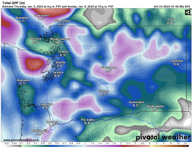
Next, the GFS (American) forecast, also showing rain through Sunday night.
The GFS shows less rain overall, with 0.5-0.75 inches for the lowlands and 0.3-0.9 inches on the coast. However, the GFS gives more rain to Eastern Washington, with 0.5-1.25 inches rain possible.
Before we switch gears to the very impactful California storm, let’s take a look at the European model snow forecast through Sunday night.
The European model shows 6-10 inches of snow at the passes through Sunday night, and 1-6 inches for communities on the eastern slopes of the Cascades, including Wenatchee, Leavenworth, and Ellensburg.
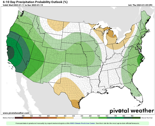
Now, let’s take a look at the overall extended outlook for rainfall. Below is the NWS Climate Prediction Center rainfall outlook from January 11-15.
The CPC outlook shows a 80-90% probability of above average rainfall centered on Central California, with 60-80% probabilities of above average rain for the rest of California and 33-50% above average for the rest of the West.
So how much rain will fall? Let’s take a look at the European model forecast through next Sunday morning (Jan. 15th).
The European model shows incredible rain amounts for Northern California…the bullseye of this pattern. San Francisco and Sacramento get 6-8 inches, with areas north of Sacramento getting an incredible 9-12 inches of rain in just over 10 days.
Next, the American GFS model, also showing total rain through the morning of Sunday the 15th.
The GFS paints a very similar picture, with amounts of 6-10 inches expected for all of Northern California.
The bottom line is that rainfall alone will cause dangerous and likely devastating flooding and landslides across the northern half of California. Successive storms will also bring rounds of strong winds, dangerous surf conditions, and incredible snow of 3-6 FEET in the Sierra Nevada. It looks like all kinds of impactful & dangerous weather are ahead for California in the coming weeks.


Even though I don't read every single word on this blog, I enjoy and learn from what I do read. Thank you for your time writing the blog.
ReplyDelete