FastCast—Wednesday, Jan. 4 to Saturday, Jan. 7:
A massive bomb cyclone (called this due to its rapid strengthening) has developed offshore off the Pacific Northwest, which will bring significant impacts to Southern Oregon and most of California over the next few days. While staying far offshore from Washington, the storm will make its presence known with strong gap winds and large waves on the coast. Due to the storm’s strength, it will create a strong cross-Cascade pressure gradient, which will cause easterly winds to accelerate through the gaps in the Cascades, along the Western Strait, along the coast, and in the Chehalis Gap (follows SR-8 between Olympia and Aberdeen). The strongest gap winds will be in the Cascade foothills, Western Strait, and Coast, with winds gusting 40-55 mph. Gap winds will be strongest from midday Wednesday through early Thursday morning. Areas outside favored locations, most likely areas from Tacoma to Mount Vernon, could see SE gusts of 25-35 mph. Additionally, the common outflow spots of the Fraser River Valley and Columbia River Gorge will have gusty winds, likely 25-40 mph in the Fraser Valley and 30-60 mph in the Gorge. 0.5-0.75 inches of rain are expected across the lowlands through Saturday, with most rain falling on Thursday and Friday. The coast will receive 1-2 inches of rain, and the passes will receive 2-8 inches of snow. Highs will be in the upper 40s to low 50s, and lows will be in the low to mid 40s.
————————————————————
Continue reading the full blog below!
A massive storm (seen on the NOAA GOES Satellite Image below) is swirling offshore of the West Coast.
This storm, classified as a bomb cyclone due to its rapid strengthening, will bring significant wind and rain to California and Southern Oregon. While still far away from Western Washington, the storm’s strength will draw winds out of the gaps in the Cascades, producing easterly winds. The storm will also bring high surf to the entire coast.
Below is the UW forecast showing this massive and very deep storm at 7 AM Wednesday.
The storm is clearly visible off the Oregon/California border. It will deepen to around 955-960 millibars, an incredibly strong, likely hurricane-force storm.
With such low pressure over the Pacific Ocean and much higher pressure inland, this storm will create a strong cross-Cascade pressure gradient, driving increased east winds.
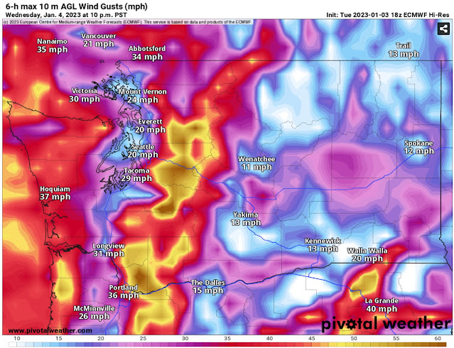
Below is the European model forecast for peak winds Wednesday evening.
The European model shows gusts of 40-50 mph in the foothills, 20-30 mph in the lowlands, and 35-45 mph for the Strait & Coast.
Next, the higher-resolution NAM forecast, showing peak winds around 6 PM Wednesday.
The NAM shows stronger winds, gusting 50-60 mph in the foothills, 30-40 mph from Tacoma northward, and 40-50 mph for the Coast, Strait, and areas west of the Columbia River Gorge.
Finally, the HRRR high-resolution forecast, also showing peak winds around 7 PM Wednesday.
The HRRR sides more with the European model, showing peak gusts in the foothills of 40-50 mph, 25-35 mph in the lowlands from Tacoma north, and 40-50 mph for the Coast, Strait, and areas west of the Gorge.
This storm will also bring massive swells to most of the US West Coast. Below is the European model forecast from Windy.com showing wave height Thursday evening.
By Thursday evening, the storm will be weakening and moving north, but massive waves of 20-35 feet will impact the coast from Southern California to Vancouver Island. The highest waves are expected from Central California to Central Oregon.
Finally, the first rounds of rain of 2023 for Western Washington are expected Thursday and Friday as this storm and its associated fronts move through. Below is the European model showing total rain through Friday night.
Expect 0.5-0.75 inches in the lowlands, with less in a potential Olympic Rain Shadow. The coast will pick up 1-2 inches, and SW WA/Willamette Valley will get 0.75-1 inch. Additionally, the passes will likely receive 2-8 inches of new snow.
Stay tuned, as there are no signs of an overall active pattern ending anytime soon.


No comments:
Post a Comment