FastCast—Sunday, Jan. 29 to Wednesday, Feb. 1:
A brief incursion of arctic air will bring very cold temperatures to the Pacific Northwest through Monday. Expect lows in the upper 20s on Sunday morning, potentially in the mid 20s for outlying areas. Brisk northeasterly winds will gust 20-30 mph around the Sound on Sunday, bringing wind chills in the mid 20s to low 30s. Highs will only reach the upper 30s to near 40 on Sunday and Monday. Monday morning will be the coldest, with lows in the lowlands reaching the low to mid 20s, and into the single digits in Eastern Washington. Conditions normalize on Tuesday, with cloudy conditions returning, highs the low to mid 40s, and lows in the mid 30s.
———————————————————
Continue reading the full blog below!
A brief cold snap is ahead for Washington State, with the coldest temperatures on Monday morning. First off, expect lows in the mid to upper 20s on Sunday morning.
The coldest temperatures will be on Monday morning. Below is the European model forecast for Monday morning’s lows.
Expect lows in the low to mid 20s in Western Washington and in the upper single digits to upper teens in Eastern Washington.
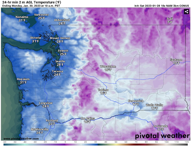
To verify this forecast, let’s take a look at the NAM high-resolution forecast for Monday morning’s lows, seen below.
The higher-resolution NAM forecast agrees with the European, showing lows in the mid 20s for Western Washington, except a bit higher near the water. Eastern Washington will drop to the upper single digits to mid teens.
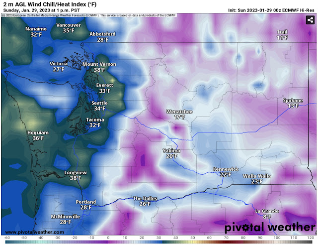
Another aspect of this cold snap will be the wind chill. Below is the wind chill at 1 PM Sunday, around the warmest time of the day.
At midday Sunday, wind chills will only be in the low to mid 30s in the lowlands and frigid-in the low teens to low 20s-in Eastern WA.
It will be even colder around 7 AM Monday, as seen in the European model wind chill forecast below.
On Monday morning, expect lowland wind chills in the mid teens to low 20s. Eastern Washington will be frigid, with wind chills in the -5º to +15º range.
Remember, even though this is a brief cold snap, make sure to take precautions, protecting pets, plants, pipes, and keeping yourself warm!


No comments:
Post a Comment