FastCast—Saturday, Jan. 21 to Wednesday, Jan. 25:
One day of active weather is ahead on Saturday, with a big change to a more stagnant and calm pattern next week. There is discrepancy on the Saturday storm, with some forecasts showing a fast-developing storm and others aren’t. If the storm develops, gusts could reach 50-60 mph on the coast, 40-50 mph along the Strait, and 30-40 mph in the lowlands. Stay tuned to Twitter for updates. Should winds develop, the combination of winds and king tides could produce coastal flooding and beach erosion in prone areas, especially on the coast. The precipitation on Saturday will arrive with chilly temperatures in the upper 20s to low 30s, so some higher hills may receive some brief snowflakes. The lowlands will receive 0.2-0.4 inches of rain on Saturday, and the Cascades will receive 6-10 inches of snow through Sunday night. Strong high pressure ridging will build on Sunday, continuing through next week. Partly to mostly cloudy conditions, with a chance of fog, will prevail. Highs will reach the mid to upper 40s, with lows in the upper 20s in outlying areas to the low to mid 30s in the remainder of the lowlands.
———————————————————
Continue reading the full blog below!
A complex forecast situation is unfolding for Saturday. The European model shows a rapidly-developing low center that will bring a narrow tongue of strong winds (called a bent-back occlusion) to the Washington Coast on Saturday afternoon. This is shown below.

The forecast above is for 1 PM Saturday. The low center moves in around Copalis Beach, with strong winds for the Central and Southern WA Coast. The European model is more aggressive with this storm than other forecasts are, but historically, it’s the most accurate.
What about wind gusts? Below is the European model forecast for peak gusts on Saturday afternoon.

The European model shows peak gusts on the coast reaching 50-65 mph, with 25-45 mph gusts in the lowlands, strongest from SeaTac south and from Everett north.
Some other forecasts show winds, but a bit different. The NAM high-res forecast is below, showing winds at 5 PM Saturday.
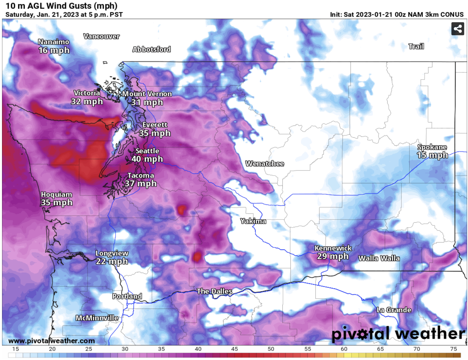
The NAM shows gusts peaking at 30-45 mph region-wide, except 50-55 mph along the Strait.
There will also be mountain snow with this system, as seen in the European model forecast below for snow through 10 PM Sunday.

The European model shows 6-10 inches of snow at Snoqualmie & White Passes, and 4-6 inches at Stevens Pass. Notice that lower elevations of Eastern Washington could receive 0.2-1.5 inches.
Also notice the SLIGHT chance of brief snow for parts of the lowlands at the onset of precipitation on Saturday morning. That is due to the cold morning temperatures that will still be in place as precipitation arrives.

Lows in the lowlands will reach the low 30s, with Eastern Washington down to the mid teens to mid 20s. Light snow is much more likely for Eastern WA than the lowlands, with brief rain/snow mix being the most likely potential before changing to rain.

Guess this won't be a good day for a walk. Enjoyed sunny weather on Thur. and Fri. and nice long walks.
ReplyDelete