No FastCast tonight…continue reading below for an update on the atmospheric river and upcoming abnormally warm temperatures.
Let’s start tonight’s update by taking a look at the rain forecasts, starting with the European model forecast for rain through late Sunday night.

Through Sunday night, expect 1.2-2” of rain for the lowlands, with less (0.8-0.9”) around Whidbey Island. The coast will receive 2-3”, with 2.5-4” in the mountains. Eastern Washington will receive 0.3-0.75”.
To see the reason for this heavy rain, below is the European Ensemble forecast for precipitable water (amount of water vapor in the atmosphere) on Saturday evening.

Notice the large area of moisture stretching from Hawaii to the Northwest, a true “Pineapple Express.” This is the atmospheric river that will bring our heavy rain and associated balmy temperatures.
Now, let’s take a look at the GFS forecast for total rain through Sunday night, seen below.

This forecast shows 1.4-2” for the lowlands, up to 3” for the Kitsap Peninsula and Hood Canal area, and only 0.2-0.7” NE of the Olympic Peninsula in the typical rain shadow area. Additionally, expect 2-3” on the coast and 2-5” in the mountains. Eastern Washington gets 0.15-0.6” in this forecast.
Now, here is a look at the National Weather Service’s National Blend of Models (NBM) high-resolution forecast for rain through Sunday night.
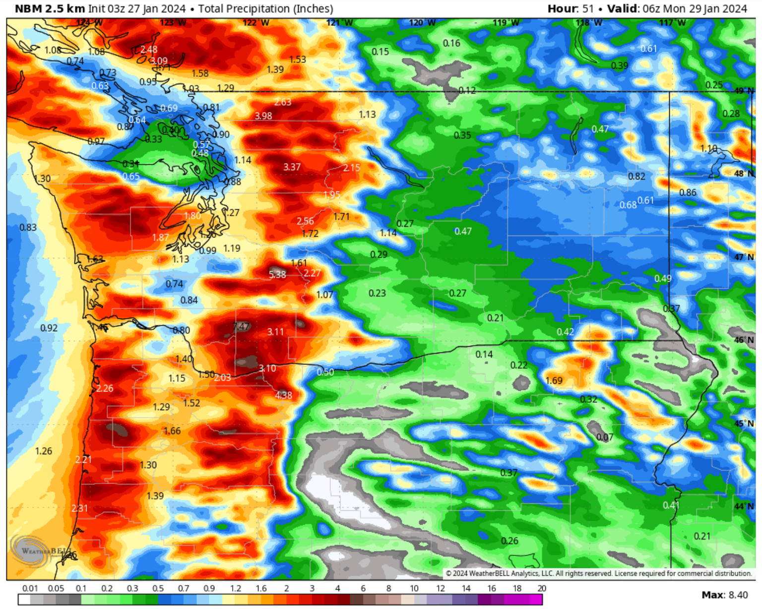
This high-resolution forecast is a combination of all forecast models, and is run by the NWS. This shows 1-1.5” in the lowlands, 1.3-2” on the coast, and 2-6” in the mountains. Eastern WA gets 0.2-0.8” in this forecast.
Let’s take a look at the flooding forecast from the NWS Advanced Hydrologic Prediction Service.

Expect the Skokomish River in Mason County to reach moderate flood stage, with the Grays River in Wahkiakum County reaching minor flood stage. The Snoqualmie/Snohomish, Nooksack, White, Chehalis, Green, Naches, Cowlitz, and Bogachiel Rivers will reach bankfull, with other rivers rising but not reaching bankfull. Most rivers will crest on Sunday.
A contributing factor to the rises on rivers will be a prolonged elevation of snow levels. Expect snow levels to remain at 6,500-8,000 feet from Friday night to Wednesday.
Now, let’s switch gears and look at upcoming temperatures. Atmospheric rivers bring strong (and moist) S-SW flow from Hawaii, which will bring a surge in temperatures for the entire region.
Below is the European model forecast for highs on Sunday.

In the lowlands, expect highs reaching the upper 50s to low 60s, with some areas south of Seattle reaching the mid 60s. The Willamette Valley and Oregon coast will be quite toasty, with highs in the low to mid 60s, and some areas from Salem southward reaching the upper 60s. The WA coast will reach the upper 50s, and Eastern Washington will reach the mid 40s to low 50s.
Next, let’s look at Monday’s highs, also from the European models, seen below.

Monday will be another warm day, with highs in the upper 50s to mid 60s for the entirety of Washington and Oregon west of the Cascades. Eastern WA will be up to the mid 40s to upper 50s.
Also, note that highs in the mountains will reach the low to mid 40s, contributing to the very high snow levels.
Another way of visualizing these temperatures is looking at the temperature anomaly. Below is the European model forecast for temperature anomaly (departure from average) on Sunday afternoon.
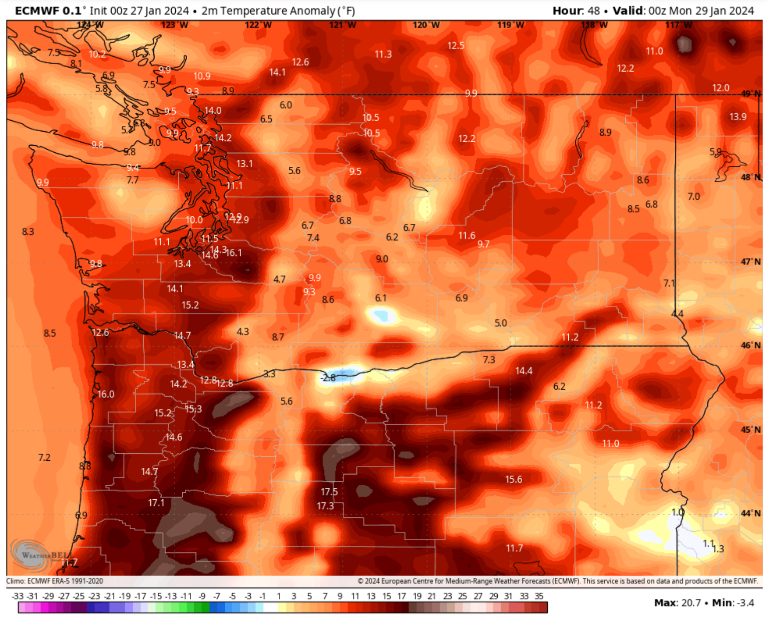
West of the Cascades, these temperatures will be 10-20º above average, with temperatures 5-10º above average east of the Cascades (up to 20º above average for Eastern Oregon). Safe to say that this atmospheric river and its strong S-SW flow will make it feel like “spring”, if only for a couple days.
Stay tuned for more information (and stay dry)!

I won't forget my umbrella today.
ReplyDelete