Live Updates on the freezing rain and snow situation across the Northwest:
This blog post will be updated hourly with new information, so stay tuned!
11:15 PM--Final Update: The band of precipitation that has brought areas of accumulating freezing rain is moving north, and will exit the metro area over the next hour. Snow is beginning in Whatcom County and SW BC, and will continue there through tomorrow. Below is a look at snow for the entire state through Wednesday night, with the NAM high-resolution forecast on the left and the European model forecast on the right.
The NAM forecast shows 0.5-1" of snow from Everett northward to Mount Vernon, with 2-3" in Skagit County and along the Strait, and 6-10" for Whatcom County. The NAM also shows 12-24" for the passes and 2-8" for most of Eastern Washington (6-8" for Spokane). The European model, meanwhile, shows 1-2" for Skagit County, 4-8" for Whatcom County, 1-2" on the Strait, and none from Marysville southward. The passes get 10-24" in the European model forecast, with Eastern WA getting 3-10", with 0.5-1" for the Columbia Basin and 7-9" for Spokane.
One more note: As a low pressure system moves in to our south, additional precipitation is possible overnight. The European model forecast for precipitation at 3 AM Wednesday is below.
Notice more freezing rain across portions of the metro area early Wednesday morning, with pockets of normal rain near sea level and snow in Whatcom County.
If freezing rain accumulates will all depend on temperature and the temperatures of roads. Areas with freezing rain on roads tonight could still have freezing rain on roads on Wednesday morning.
Stay updated on school closings and delays here: KOMO News School Delays Page
------------------------------------------------------------------------
9:00 PM: Conditions vary across the region, with most areas from Federal Way and Auburn northward to SeaTac reporting freezing rain sticking to trees and trash cans, etc., but not roads. Areas including Olympia, Lake Tapps, and parts of Bonney Lake report freezing rain sticking to roads.
Temperatures across the region are very marginal. However, note how a slight difference in temperatures (30° in Olympia vs. 32° in Federal Way & SeaTac) can bring much different effects for freezing rain.
------------------------------------------------------
7:40 PM: Rain is now falling at my house in Federal Way, and since rain began, temperatures dropped from 33.3° to 31.5°. Additionally, relative humidity rose as the atmosphere moistened quickly. It may be difficult to tell if rain or freezing rain is falling, as they look the same. Freezing rain will immediately freeze upon contact with surfaces.
Note: forecasts did not have freezing rain starting to accumulate until 8-9 PM across the metro area. Some areas may start as rain, then change to freezing rain. Stay tuned
-------------------------------------------------------
6:40 PM: Freezing rain has turned I-5 near Kelso into a sheet of ice, as seen in the WSDOT camera image below.
Freezing rain is currently falling from the Centralia/Chehalis area southward, although not causing much of an impact around Centralia/Chehalis yet.
Below is a look at temperatures at 6:40 PM.
Most of the region is between 31 and 34 degrees, except some areas, mainly around Seattle, in the 35-37° range. Temperatures will likely go down a few degrees as precipitation begins.
Freezing rain is still expected to start between 7 and 8 PM for Tacoma and Olympia, and 8 to 9 PM for Seattle. Next update by 7:30 PM.
---------------------------------------------------
5:30 PM: Freezing rain is now impacting the Portland metro area, with the edge of the precipitation now between Kelso and Chehalis. Below is the radar image as of 5:10 PM (red is freezing rain).
Freezing rain is starting to coat streets in the Portland metro area, as seen in the ODOT image below in downtown Portland.
In addition to previous snow and ice pellets, the roads are getting covered by freezing rain.
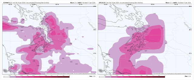
Finally, here is a look at the latest forecast for total freezing rain from the European model (left) and American GFS model (right).
The European model (left) shows 0.1-0.2” of ice for areas Seattle south, with pockets of 0.05-0.1”. For areas from Seattle to Mount Vernon, the European model shows 0.2-0.5”. The American GFS model shows 0.1-0.25” for the entire region, with the most for areas Seattle eastward to North Bend.
Next update by 6:30 PM. Stay tuned.
——————————————————————
4:00 PM: Freezing rain is now being reported as far north as Aurora, Oregon, which is 20 miles south of Portland.
Although the radar map below shows precipitation north of Portland, it is falling into very dry air, so the air must be saturated before precipitation reaches the ground. So, basically, just because there is precipitation over an area on radar doesn't mean it is reaching the ground yet.
Areas where freezing rain has been falling for a few hours are already seeing impacts. Below is a ODOT TripCheck traffic camera image near Coburg, just north of Eugene, showing a vehicle in a ditch due to ice.
Stay tuned for the next update between 5:00 and 5:30 PM.
----------------------------------------------
2:10 PM: Precipitation is currently moving northward through the Willamette Valley. Freezing rain is falling and causing traffic issues in Eugene, with light snow being reported in Corvallis.
This is about on-par with where the European model forecast showed precipitation at 2 PM, seen below.
This forecast has been correct with precipitation timing, temperatures, and (mostly) with precipitation type, except on the Oregon Coast, where some areas of freezing rain are currently falling.
Based on this forecast, freezing rain reaches...
Salem within the next hour
Portland from 3-4 PM
Olympia from 6-7 PM
Tacoma from 7-8 PM
Seattle from 7-8 PM (with pockets near the Sound with normal rain)
Everett from 9-10 PM
Precipitation reaches Whatcom County by 10-11 PM, but will fall as snow.
Stay tuned for the next update around 3 PM.


No comments:
Post a Comment