FastCast—Sunday, Jan. 21 to Friday, Jan. 26:
After a prolonged arctic outbreak brought frigid temperatures to the Pacific Northwest, the pattern has changed, and a wet and somewhat warmer pattern has replaced it. Continual systems will bring rounds of rain to the lowlands through this week, with a couple breaks in the rain on Tuesday and Thursday. Through Friday, the lowlands will receive 2-2.5” of rain, with a rain shadow bringing less from Everett to Port Angeles. Expect highs to reach the upper 40s to low 50s across the lowlands each day. This will be a change from the past few weeks, and as a part of that change, snow levels will increase to 4,000-5,000 feet in the mountains. This will bring up to 12-18” of snow to Stevens and White Passes, and higher ski and recreation areas will receive as much as 24-36”.
———————————————————
Continue reading the full blog below!
A rainy week is in store for Western Washington, with multiple systems bringing rounds of rain to the region, with snowfall for the higher passes and ski areas. Let’s take a look at the forecast.
First, the European model forecast for total rain through Friday night.

This forecast shows the lowlands receiving 2-2.5” of rain, except less in a rain shadow along the northern Olympic Peninsula. The coast will receive 3.5-5” through Friday, with Eastern Washington receiving 0.4-1”, more closer to the Cascades. Expect areas from Shelton to Bremerton to receive 2.5-3.5”.
Let’s compare this to the American (GFS) model, also showing total rain through Friday night.

This forecast shows 1.5-2.5” of rain in the lowlands, with a very pronounced rain shadow along the northern Olympic Peninsula. The coast will receive 3-5”, with Eastern WA receiving 0.5-1.25”, except 0.3-0.4” in the Columbia Basin.
This may seem like a lot of rain over one week, but that is because of multiple systems that will move through. Generally, expect steady rounds of rain from Sunday to Monday, from Wednesday to early Thursday, and from Friday into next weekend.
Next, let’s take a look at the forecast from the European model showing total snow through Friday.
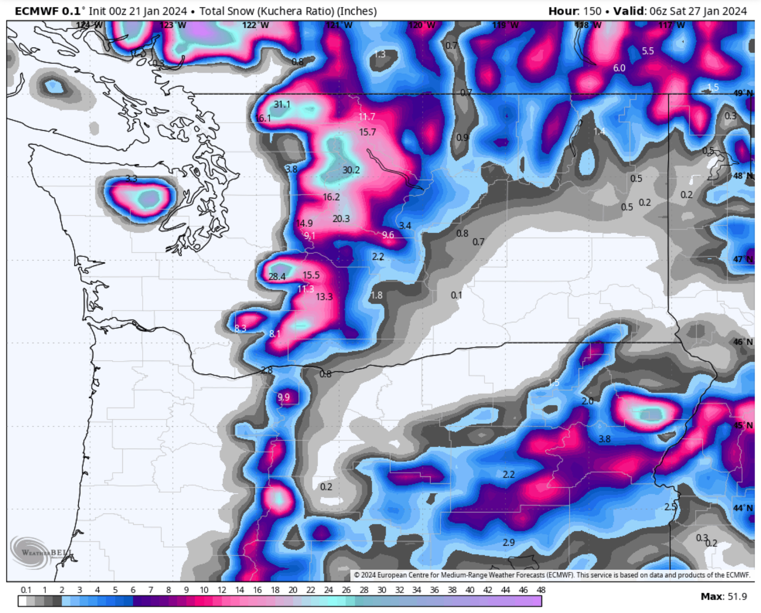
This is a bit of a difficult forecast for the passes, since snow levels will likely remain at 4,000-5,000 feet. Areas over those levels will likely receive 1-2 feet of snow, except some areas like Paradise and Crystal Mountain, which could receive up to 3 feet. Some parts of Eastern Washington will receive 2-4” of snow, mainly Ellensburg and Wenatchee. Spokane will get up to 0.5”.
Finally, let’s take a look at the temperature forecast for the Seattle metro area, shown below on the European model ensemble forecast.

Expect highs to reach the upper 40s to low 50s, with lows rising to the upper 30s to low 40s. These temperatures are significantly warmer than last week, and are more seasonable for January.
Stay tuned for more information about the continuing wet & active pattern.

No comments:
Post a Comment