FastCast—Wednesday, Jan. 24 to Friday, Jan. 26:
Consistent rain will continue across the Northwest through the end of this week. Even heavier rain is ahead over the weekend and into the final week of January. Across the lowlands, expect 0.5-1.25” of rain, with the potential for less rain over the North Sound due to a rain shadow. Most rain will fall from early Wednesday to late Thursday, with a break on Friday, before rain starts again Friday evening, continuing through the weekend. Through Friday, expect highs in the upper 40s to low 50s, with lows in the low to mid 40s. In the mountains, snow levels will remain between 4,000 and 4,500 feet, before rising rapidly late Friday night. Stevens and White Passes will receive up to 5-8” of snow through Friday.
————————————————————
Continue reading the full blog below!
A rainy pattern will continue across the region after a nice break in the rain on Tuesday. Systems will move through from Wednesday to Thursday and then from Friday into the weekend. Let’s take a look at the forecast!
First, the European model forecast for total rain through Friday night.

Expect 0.75-1.25” of rain for the lowlands and Willamette Valley, with some areas, mainly from Port Angeles to Everett, getting 0.4-0.6” of rain due to the rain shadow. The coast will get 1-2”, and Eastern Washington will get 0.15-0.4”.
Let’s compare this to the GFS forecast through Friday night, seen below.

This forecast shows a more expansive rain shadow, mainly from Everett to Bellingham (0.3-0.5”), with the rest of the lowlands getting 0.6-0.9” of rain. The coast will get 1-2”, with Eastern WA getting 0.1-0.35”.
Now, let’s take a look at the snow forecast from the European model through Friday evening.

This forecast shows 8-12” at Stevens and White Passes through Friday, with less likely at Snoqualmie Pass as snow levels hover near or above pass level. Some lower elevations of Eastern Washington (mainly on the east slopes of the Cascades) could receive 1-3” of snow.
Let’s compare this to the GFS forecast for snow through Friday night, seen below.

This forecast also shows 8-12” at Stevens and White Passes, with potential for 0.5-3” of snow north of I-90 and along the east slopes of the Cascades.
Finally, let’s take a look at the potential rain through the end of January. Below is a graphic comparing the European Ensemble (left) and GFS Ensemble (right), showing total rain through the evening of January 31st.
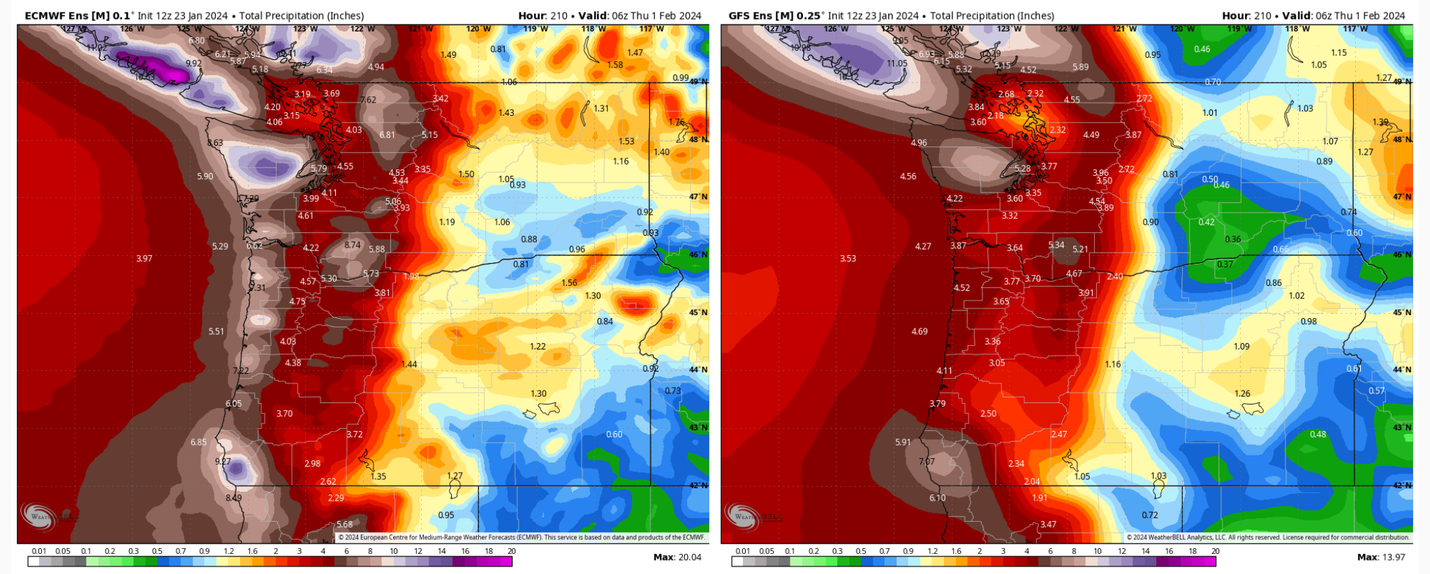
These forecast shows that the lowlands could receive 3-5” through the end of the month, with up to 5” in the Willamette Valley, and 0.5-1.5” in Eastern Washington and Oregon. The WA & OR coasts will be slammed with 5-8” of rain through the end of the month (isolated higher totals are possible).
Additionally, forecasts predict snow levels likely rising to 7,000-8,000 feet for the Olympics and Cascades, and remaining there for multiple days. This could bring flooding impacts across the region, so stay tuned over the next few days for more information.

No comments:
Post a Comment