Sunday, June 14, 2020

Warmer Weather At Last...But Rain First

We will finally have warmer weather...but of course it has to rain first. 

We have received 0.98 inches of rain this month in Puyallup, and amounts of 0.90-1.5 inches are common around the South Sound. This is more rain than our last two June’s combined. 

Rain moves on the coast Sunday night and spreads into the Lowlands. It turns showery by Monday afternoon and remains so through Tuesday. 

Here is the UW forecast model showing forecast precipitation through the next 48 hours (4 PM Tuesday). 


Our area receives 0.16-0.64 inches. Forecasts show common amounts around 0.3-0.5 inches. 

However...there is warmer weather coming! Finally!

Forecasts show that a high pressure ridge begins to build by Wednesday and Thursday. Rain chances remain through Wednesday. Then Thursday will be mostly sunny, with highs in the 70s. 

Highs from Thursday through Sunday are in the mid-upper 70s, peaking on the weekend! It will be partly sunny, with slight chances of rain on the weekend, but it looks mostly dry!

Wednesday, June 10, 2020

Muggy Weather Fuels A Chance of Thunderstorms

Have you stepped outside and noticed that it's warm and really muggy? If you haven't...just trust me. 

Why is it so muggy? 2 reasons...warm temperatures (in the 70s around most of the area), and high relative humidity & dew points. The muggy weather will fuel a chance of thunderstorms this afternoon and evening. Let’s examine the details and why it’s so muggy today. 

Relative humidity (measure of moisture in the atmosphere) is quite high for midday in Western Washington. Take a look at this map showing current humidity.

Wow...humidity between 55 and 75 percent...at mid-afternoon. This is pretty rare for Western Washington, to have values like this at this time of day. Normally, we would have 30-50%.

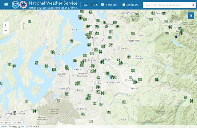
Higher humidity leads to higher dew points, and in turn more “mugginess.” Here’s a map showing current dew points at 3:30 PM. Normal dew points on an average day at this time are around 45°.


Whoa! Look at that! Dew points of 55-65 degrees, with some isolated spots higher or lower. This is why it feels so muggy. You’d expect to see these kind of numbers in the Midwest rather than the PNW. 

This muggy atmosphere and warm temperatures will fuel some instability through the afternoon and evening. The HRRR forecast model shows CAPE (instability) values of 200-800 j/kg. That is decent instability for our area.


I would expect the highest chance of thunderstorms to be near the mountains and foothills between 3 and 8 PM. Isolated storms in the lowlands wouldn’t be out of the question, though!

Some storms could contain dangerous lightning, heavy rain, gusty winds, and possibly some hail. Best to be prepared and go indoors for at least 30 minutes after hearing thunder. 

Monday, June 8, 2020

Rainy Weather System Tuesday Followed by Showers

June has already been cooler than normal...and it's about to become wetter than normal. (I'm sure you're not surprised). 

By Monday night, a strong frontal system will be on our doorstep. Associated rain will move in to the lowlands from the coast by 11 PM Monday. Expect steady light-moderate rain through most of the day on Tuesday. 


This forecast model from UW shows 0.32-0.64 inches of rain through 5 AM Thursday. That forecast total is more rain than all of June 2019. You'll see some rain-shadowing near Port Townsend, and the coast+mountains will get the brunt of the rain from this system. 

Rain from this system will continue through Tuesday night, but it will become showery. 

Of course, in true Washington fashion, the rain doesn't stop there...look at the forecast totals through next Monday, the 15th.


The Cascades in WA, OR, and BC get a 2.5+ inch soaking. The lowlands get 1.2-2.5 inches of rain. 

After the Tuesday system, chances of rain (mainly showers) will remain through next week. Some forecasts show a chance of thunderstorms in the afternoons on Thursday and Friday. 

In case you were wondering...our area average rain for June is around 1.5 inches. By next Monday, we could have upwards of 2 inches of rain!! That would make this month the 5th this year with above normal precipitation. 
 

Next Storm System Hits Western Washington

  8-26 Video Briefing: Next Storm System Hits Western Washington