Many of you were impacted by the strong windstorm on Wednesday, January 13th. This blog will examine the following:
- Why was this storm so strong?
- What made this storm "unexpected" and why wasn't there a better forecast?
- Why was there so much damage & power outages?
- What can we learn from this storm?
Peak gusts from the January 13th, 2021 windstorm.
1. Why was this storm so strong?
Late on the evening of January 12th, a small and rapidly developing low center made landfall on Southern Vancouver Island. As this weather system moved away, it created very steep rises in air pressure that caused strong winds across Western Washington.
Storms that are strengthening as they make landfall tend to be the strongest and most impactful types of storms.
Since the January 13th windstorm was strengthening as it made landfall (and continued to strengthen afterwards), it was a sign that it would be a strong storm.
The second reason this storm was so strong is due to the fact that this storm was strengthening as it made landfall, it produced very strong pressure rises in the wake of the low center.
The graphic above shows pressure observations at Sea-Tac Airport from 11 PM Tuesday (12th) to 4 AM Wednesday (13th). Pressure rose from 1002.4 millibars to 1007.5 millibars in ONE HOUR!! A 5.1 millibar pressure rise in one hour is quite large, and will produce strong winds. That steep of a pressure rise is rare for Western Washington.The largest pressure rises around the Puget Sound area happened between 12 and 1 AM on the 13th, directly causing the peak winds and hundreds of thousands of power outages.
2. What made this storm "unexpected" and why wasn't there a better forecast?
This storm was unexpected because it was relatively weak and wasn't picked up by most of the forecast models. Additionally, its fast development caused a strong pressure gradient which resulted in strong winds.
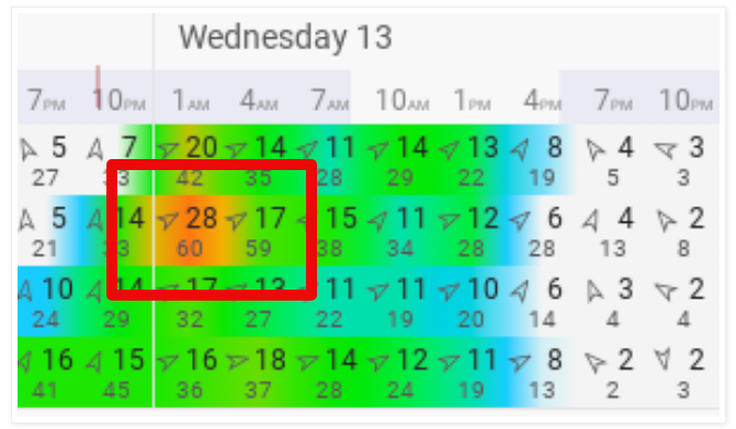
One forecast model (the European model) had a forecast for a rapidly developing storm with winds of 50-60 mph two days before it happened. However, because no other forecast predicted this, the European model was considered an "outlier."
Above is the blend of 4 forecast models for Puyallup that I posted on this blog just hours before the storm. The red outlined area is the European Model's forecast. While not perfect, it outlined the possibility of strong winds (50-65 mph) and predicted the storm's development perfectly, unlike the other models.
Seeing the European Model's prediction verifying as the storm developed on the evening of the 12th, forecasters at NWS Seattle issued a Wind Advisory at 8 PM, just 4-5 hours before the storm began. These forecasters did a great job seeing the developing storm and warning the public accordingly.
However, the relatively late warning of this storm led to most of the public being relatively unaware that a strong storm was coming until the strong winds hit. Thankfully, I was able to publish a blog about the storm (though I underestimated the winds) by 9:30 PM on the 12th.
3. Why was there so much damage and power outages?
A big impact of this windstorm was the large amount of power outages and tree damage especially due to saturated ground, something that had been predicted beforehand and was a big concern.
Our heavy rains in the previous weeks set the stage.
This graph from the Western Regional Climate Center shows that since January 1st, we have received 200-300% of our average rain (2-3 times the average) in Western Washington (totals of 5-9 inches for January so far).
Additionally, the graph below shows recent soil moisture levels.
When was the peak saturation in soils? You guessed it...midnight on the 13th, the same time as the peak winds.
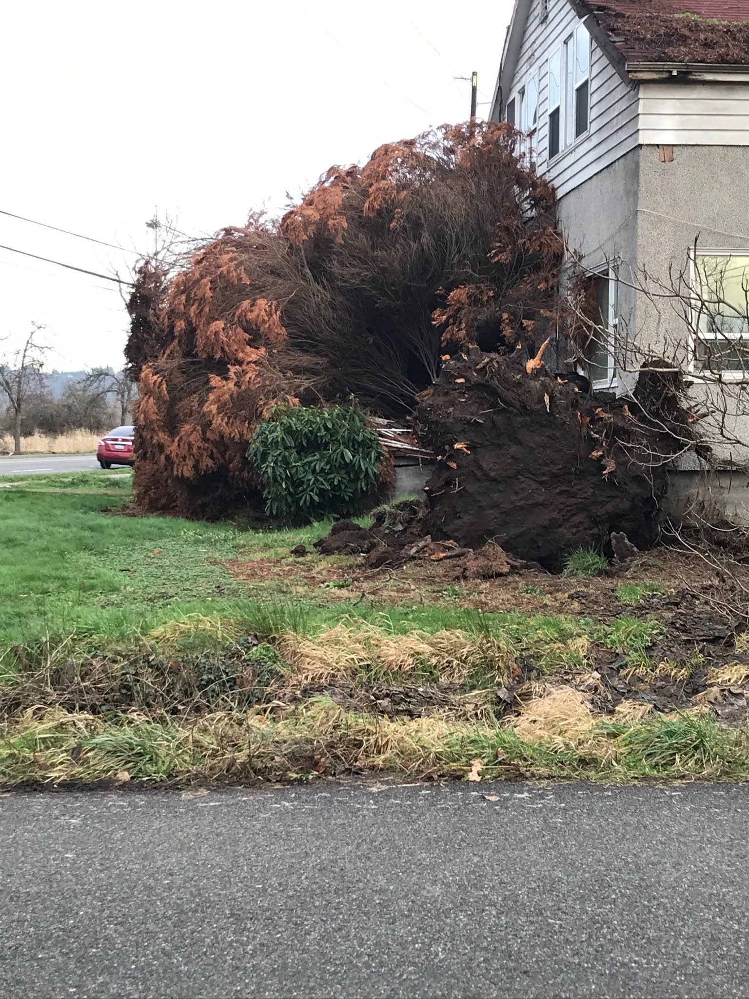
These factors above, combined with the 40-65 mph wind gusts in the Puget Sound area, were the main reasons for the large amount of power outages and storm damage from this windstorm, as seen below.
Those kind of scenes were common around Western Washington following the storm.
At the storm's peak, nearly 569,000 people were without power in Western Washington.
This storm would go on to produce wind gusts of 60-120 mph across large areas of the Western & Central United States.
 |
A map of damaging wind reports from January 13th-15th, made by the National Weather Service and featured by The Washington Post.
Wow! The storm's extent is revealed in that map, with hundreds of wind reports over many states. |
4. What can we learn from this storm?
We can definitely take some lessons away from this windstorm. I've listed some below.
- It is always good to be prepared. Sometimes weather events happen with short notice. Have a way to receive weather alerts and be prepared for the impacts of strong winds and other hazardous weather.
- Large amounts of rain followed by strong winds will result in lots of damage. We already knew that this occurs, but it is a good reminder that shows what happens when heavy rain and strong winds combine.
- Don't count out a forecast model because its prediction is different than the others. While this mainly applies to meteorologists/weather enthusiasts, it is important to remember that a forecast isn't incorrect until the predicted event happens (or doesn't).
- Storms that strengthen as they make landfall are the strongest kinds and produce the biggest impacts. Also, a storm doesn't have to have a deep low pressure to pack strong winds, as we saw.