Sunday, April 25, 2021

Most Rain In A Month & A Cloudy Week Ahead

This past weekend gave us much-needed rain, the most rain since late March. The weekend rain totals are below.


Most of the area received 0.25 to 0.8 inches of rain. 

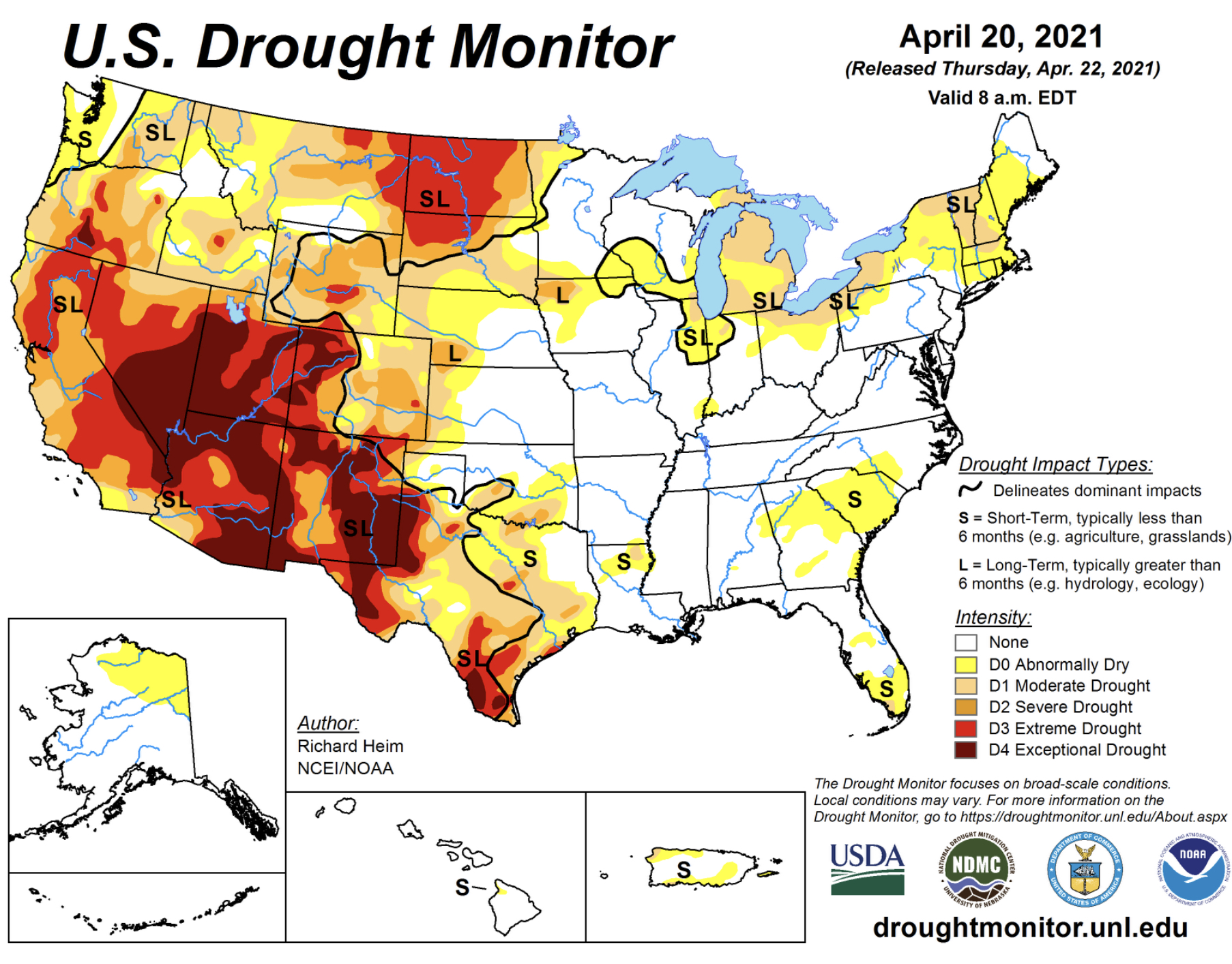
The previous dry spell was enough to place Western Washington in the “abnormally dry” category of the US Drought Monitor. Below is the drought monitor, categories in the bottom right.


Thankfully, Western Washington’s drought is only slight and short term compared to the major, exceptional drought occurring across most of the western and southwest United States.

The week ahead is going to be mostly cloudy and dry, before rain returns later on Friday. Puyallup’s forecast from Weather Underground is below.


Notice temperatures to likely be above 60 degrees each day, peaking with a warm and possibly muggy day on Thursday, when temperatures in the mid to upper 70s are likely.

The weekend’s rain freshened up the atmosphere after our long dry spell...and now we return to somewhat “normal” spring weather.


Thursday, April 22, 2021

Return of Clouds and Rain

We have had a record-breaking stretch of April weather, with the warmest 7 day stretch in Seattle history for April. Multiple records were broken and we went over 5 days with no clouds in sight.

However, change is upon us. Thursday was the coolest day in over a week and the cloudiest in nearly 2 weeks, a summer-like gap between cloudy days. Rain makes its return this weekend as well, ending the longest dry spell since September 2020.

This weather pattern change is due to the breakdown of the massive and persistent high pressure ridge that brought our spring heat wave. Two maps from the UW forecast model are below. The top one is for last Saturday (peak of the heat) and the bottom one is for 8 AM Saturday.


The high pressure ridge is completely gone, replaced by a low pressure trough that will bring clouds and rain.

Below is the Puyallup forecast from Weather Underground.


Rain is likely to return late Friday night through Saturday. Temperatures reach the low-mid 60s with the exception of Saturday, where highs struggle to reach the low 50s. The highest chance of rain is on Saturday, with a dry day Sunday and chances of showers to start next week.

The UW forecast below shows expected rain through 5 AM Sunday.


Expect 0.3 to 0.75 inches of rain from Friday night to late Saturday. This will be our first rain in nearly 2 weeks, so be prepared for some slick spots on the roads. Higher rain totals are expected near the coast, in the foothills, and north of Everett.

A return to more traditional spring weather is in the forecast. The rain should be refreshing to the atmosphere after our record-breaking heat & sun!


Tuesday, April 20, 2021

Abnormally Dry Conditions Prompt Over 90 Wildfires In Washington State

Tuesday marked the 6th consecutive day above 70 degrees at SeaTac Airport. That is the longest such streak in the month of April in over 125 years of record keeping in Seattle. 

This record dry streak has prompted above normal fire danger across Washington State, with the Department of Natural Resources responding to over 90 wildfires in a week (ending Monday). Most of these fires have burned under 100 acres, but it is significant that so many fires are burning in April in the first place.


The Department of Natural Resources (DNR) has issued
burn restrictions effective until rain dries out vulnerable grasses. These restrictions are available below:

https://burnportal.dnr.wa.gov/

Below is a map from MyRadar Weather that shows an approximate number of fires that are currently burning around the state.


As you can see, northeast Washington has been hit particularly hard, with many small wildfires popping up, mainly due to strong winds and very dry conditions. 

Western Washington has been impacted by these fires as well. Several small wildfires have occurred around the area, with some forcing the use of helicopter water drops and evacuations being issued.

Fires were reported in Eatonville, Lacey, Auburn, and even on the coast in Pacific County.


This brush fire burned about 10 acres on Friday just north of Eatonville.


The Green Valley Fire sparked due to an out of control burn pile on Sunday evening and has burned about 50 acres and is 75% contained as of Tuesday evening. The fire's spread was aided by winds and low humidity. Level 1 evacuations are in effect (briefly level 2 on Monday). Helicopter water drops were required on Sunday evening. The fire is difficult to contain due to the terrain of the area. The fire is located around 17100 SE Green Valley Road.

Updated information about the Green Valley Fire here: https://thenwfireblog.com/2021/04/20/day-3-green-valley-fire-continues/

Fires were even reported on the coast in Pacific County:


So...what role did weather play in these and other fires around Washington State? 

We will specifically be focusing on conditions in Western Washington, but similar conditions brought fire danger in Eastern WA.

Below, I have made a list of minimum humidity in Puyallup since last Tuesday (4/13).

Tuesday, 4/13: 18%
Wednesday, 4/14: 22%
Thursday, 4/15: 21%
Friday, 4/16: 17%
Saturday, 4/17: 15%
Sunday, 4/18: 17%
Monday, 4/19: 26%
Tuesday, 4/20: 24%

Low humidity over the past week has been a key contributor to the large amount of small wildfires across the state. Average April humidity is 72%, meaning that in the past week, we have had humidity around 52% below average. This, combined with occasionally gusty winds and temperatures of 70-85 degrees, explain the large amount of fires popping up. 

Expect fire danger to decrease by the end of the week and into the weekend, when higher humidity and rain return to the area.

An informative article from The News Tribune is below, talking about the upcoming summer fire season and what the recent fires mean for summer.

We are still a couple months from the start of summer fire season, and while wildfires are generally less frequent west of the Cascades, we saw this past September in Bonney Lake that fires can ignite in Western Washington. 

It's never too early to prepare in the case of a wildfire. Here is a good graphic from the Washington DNR Wildfire Preparedness Site.


Stay safe and check out the links in this blog!


Image found here.


Next Storm System Hits Western Washington

  8-26 Video Briefing: Next Storm System Hits Western Washington