Friday, December 23, 2022

Significant Pattern Change: Heavy Rain, Lingering Ice, Warmer Temperatures

 FastCast—Saturday, Dec. 24 to Monday, Dec. 26:

What a week! It has been a downright crazy week of winter weather across the region, and threats aren’t over for all. The largest ice storm Western Washington has seen since January 2012 brought 0.1-0.4 inches of ice across the region, producing huge travel impacts and making roads very treacherous (lowland side streets could remain icy through early Saturday). All areas have warmed into the mid 30s to mid 40s and begun melting except for parts of the Willamette Valley, Whatcom County, Snoqualmie & Stevens Passes, and the Columbia River Gorge. These areas will be impacted by an additional 0.1-0.2 inches of ice (except 0.3-0.5 inches in the passes/gorge) through early Saturday, except continuing through Saturday for the passes. Expect significant travel disruptions over the passes on Saturday. Widespread 0.1-0.3 inches of ice is expected across Eastern Washington on Saturday. In the lowlands, a heavy rain event is ahead, with 0.75-2 inches of rain from Saturday morning to late Christmas Day (Sunday). The main concern will be urban flooding due to runoff and snowmelt, so be prepared for areas of standing water and large puddles. Temperatures will skyrocket into the upper 40s to low 50s, and snow levels will shoot up to 8,000 feet (but cold air will keep freezing rain at Snoqualmie & Stevens Passes). Winds will gust 20-30 mph, and 40-50 mph from Everett northward. Another moisture-laden system will approach the area on Monday, so stay tuned!

————————————————————————

Continue reading the full blog below!

In 24 hours, we’ve gone from our most widespread & impactful ice storm in 10 years to talking about heavy rain and much warmer temperatures.

Below is the European model forecast, showing total rain through Christmas night.


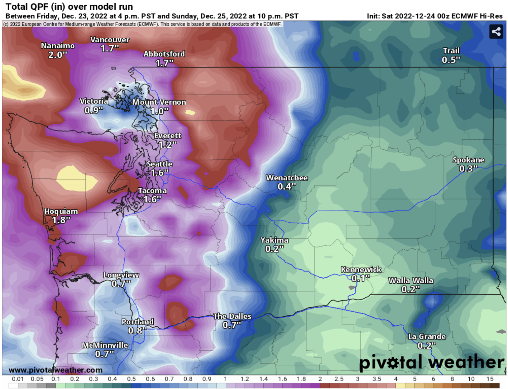
Expect 1-2 inches across the lowlands, with less in the Olympic rain shadow. The mountains will be soaked with 3-5 inches of rain, and the coast will pick up 1.5-3 inches.

However, the freezing rain threat is far from over, especially for Snoqualmie and Stevens Passes and the Columbia River Gorge. Below is the European model forecast for freezing rain through Christmas night.


Expect 0.1-0.2 inches of freezing rain for the Northern Willamette Valley and Whatcom County. Impactful freezing rain is expected for Snoqualmie & Stevens Passes and the Columbia River Gorge, with 0.5-0.75 inches of ice accretion expected. Major travel impacts are possible with this setup. Additionally, expect 0.1-0.3 inches of ice across Eastern Washington.

Freezing rain will linger longest in the Columbia River Gorge and Snoqualmie & Stevens Passes. Expect freezing rain to end in these locations by Saturday evening, though the impacts of 0.5-0.75 inches of ice will remain into Christmas.

Freezing rain should end across the Pacific Northwest by Christmas night.

Let’s focus on the heavy rain threat for the lowlands. Below is the UW model for the amount of water vapor in the atmosphere at 7 AM Saturday.


This shows a large area of deep subtropical moisture moving into Western WA & OR. This is what will bring significant rain totals through Christmas, with another system bringing another round of heavy rain starting Monday.

High-resolution forecasts, while not always good with snow, are helpful in pinpointing areas of heavier rain totals. Below is the NAM forecast for rain through late Christmas night.


The NAM forecast shows 0.75-1.5 inches of rain across the lowlands, with a pronounced rain shadow on the NE Olympic Peninsula. The NAM gives the coast 1.5-4 inches, and the mountains get 3-8 inches. 

Next is the HRRR forecast, which paints a similar forecast through Christmas evening.


The HRRR shows 0.75-2 inches of rain in the lowlands, following the pattern of the most rain from Everett to Tacoma. There is a pronounced rain shadow on the NE Olympic Peninsula and Whidbey Island. The coast receives 1.5-3 inches, and the mountains get soaked with 3-8 inches.

What about temperatures? We will have our warmest temperatures (by far) in over a week, with some areas being 20-30 degrees warmer than 24 hours before. Below is the European model’s forecast for high temperatures on Saturday.


What an increase from the past two days. Expect lowland highs in the mid 40s to low 50s, with potential mid 50s on the coast! However, notice the lingering cold air in the Columbia River Gorge and Eastern Washington, which will aid in producing freezing rain. Highs in the Gorge and Eastern Washington will be in the upper 20s to mid 30s, with some areas getting above freezing, particularly out of the topographic bowl of the Columbia Basin.

Finally, a look at the 24-hour temperature increase at 10 AM Saturday.


Expect Saturday morning’s temperatures to be 10-20º warmer than Friday in the lowlands, and 15-25º warmer in Eastern Washington and the Willamette Valley!

Stay tuned, as much more stormy weather is ahead. I will also post an ice storm recap blog on Saturday, including photos!

Thursday, December 22, 2022

Major Ice Storm on Friday

A significant ice storm is expected for much of Washington and parts of Oregon over the next couple days, with significant impacts possible for the Seattle and Portland metro areas.

As of 8:00 PM Thursday, freezing rain has already begun around Portland, and has been reported as far north as Grays Harbor County in Washington.

Expect freezing rain to start from 11 PM to 4 AM from Seattle southward, and later in the morning north of Seattle. Freezing rain will taper west of the Cascades by Friday evening. Freezing rain will impact Eastern Washington on Saturday, and will impact the Cascades and Columbia River Gorge from Friday through Saturday.

This has potential to be a high-impact event, with significant travel disruptions (including shutdowns of PDX and SeaTac), widespread power outages, and a significant tree damage potential.

Below is the European model forecast for total freezing rain accumulation.


The European model forecast shows 0.25-0.5 inches of ice accretion from the Willamette Valley to Seattle and on the coast. This would be very disruptive. The Columbia River Gorge and Snoqualmie/Stevens Pass get very bad freezing rain totals of 0.5-1.25 inches. Eastern Washington will pick up 0.1-0.25 inches of freezing rain, but likely on Saturday.

Next, let's look at the GFS model forecast for total freezing rain accumulation.


The GFS forecast shows 0.1 to 0.3 inches of ice for areas from Seattle to the Willamette Valley, the WA Coast, and Whatcom County. This forecast likely overdoes the freezing rain in the mountains & Gorge, since 1.5-3 inches of ice seems unreasonable.

Next, let's look at the high-resolution Canadian model, the RDPS.


The RDPS shows a similar situation as the Euro, with most freezing rain (0.25-0.5") from Seattle to Eugene, plus 0.3-0.5 inches on the Coast and Whatcom County.

Finally, the HRRR forecast.


This is the highest-resolution forecast available, and it paints a good picture showing the localized differences in freezing rain. The HRRR shows 0.25-0.5 inches of freezing rain from Seattle south into the Willamette Valley, in Mason and S. Kitsap Counties, in Whatcom County, and 0.5-1" in the Columbia River Gorge. On Saturday, 0.05-0.4 inches is possible across Eastern Washington, highest near Wenatchee and Walla Walla.

Some areas will receive snow before a changeover to freezing rain. Let's take a look at the European model forecast for snow prior to the changeover.


Expect a trace to 1 inch from Seattle to Everett and on the Kitsap Peninsula. Eastern Washington will get 1-4 inches, and areas from Mount Vernon northward into BC will get 2-6 inches.

This graphic below from the National Weather Service talks about how dangerous freezing rain can be.


With power outages possible, below is a list of local public utilities sites to monitor:

Puget Sound Energy Outage Map

Tacoma PUD Outage Center

Seattle City Light Outage Map

As always, the best place to get frequent updates is Twitter (linked on top right of blog site), local news stations, Pacific Northwest Weather Watch on YouTube, and NWS Seattle.

Stay safe & stay tuned. More active (but wetter & warmer) weather is ahead through the end of December.

Wednesday, December 21, 2022

Extreme Cold Across Washington, Ice Storm Possible on Friday

No FastCast today. Continue reading the full blog below. (Ice storm information at bottom)

Extreme cold is expected across Washington state on Thursday, with frigid temperatures and incredibly cold wind chills. 

Let’s start with the forecast for low temperatures on Thursday morning. The NAM high resolution forecast is below, and it is likely showing the coldest possible solution.


If this forecast verifies, expect lows in the lowlands in the low to mid teens. Whatcom County will reach the low single digits, the coast will reach the low to mid 20s, and Eastern Washington will reach 20 below to 5 above.

For a bit more moderate of a forecast, below is the European model for Thursday morning lows.


The European model shows the lowlands dropping to the mid teens to low 20s, with some colder spots. Areas from Everett northward drop to the low single digits to the low teens, the coast drops to the low 20s to low 30s, and Eastern Washington drops to 20 below to 5 above (colder in the northern mountains and valleys, potentially as low as 30 below).

These temperatures are hazardous on their own, but due to a strong Arctic high over the Great Plains, there will be a cross-Cascade pressure gradient, causing biting easterly winds across the lowlands.

Wind chills will be coldest Thursday morning, around sunrise. Below is the NWS NBM forecast for wind chills at 8 AM Thursday.


Wind chills will be in the low single digits to low teens across Western Washington, except in the foothills and Whatcom County, where wind chills will reach -5 to -15. Incredible wind chills of -5 to -30 are expected for the Cascades and Eastern Washington.

Let’s see if the European model agrees. Below are the European model forecasts for wind chills at 7 AM Thursday.


The European model agrees, showing wind chills in the low single digits to low teens across Western Washington, except 0 to -10 in the foothills and from Mount Vernon northward. The European agrees with the incredible -5 to -35 wind chills in Eastern Washington and the Cascades.

High temperatures on Thursday won’t offer much relief from the cold. Below is the European model forecast for Thursday’s highs.


The European model shows highs in the low to mid 20s in lowlands, and in the low single digits to low teens in Eastern Washington (-5 to 5 in the Cascades).

Let’s compare this to the NAM high-resolution model, showing a colder forecast for Thursday’s highs.


The NAM forecast shows highs only getting into the upper teens to low 20s, with even the coast getting into the mid to upper 20s. Eastern Washington reaches the single digits to mid teens, with the Cascades only reaching -5 to 5. 

Wind chills around midday will remain very cold, as seen below in the European model forecast for 1 PM Thursday.


Around midday, the European model forecast shows wind chills remaining in the mid teens to low 20s, except in the single digits in Whatcom County. Eastern Washington and the Cascades will have wind chills in the -15 to +10 all day. 

These frigid wind chills all day are caused by the strong pressure gradient across the Cascades, which will bring winds gusting 15-30 mph in the lowlands and potentially 35-50 mph in the Cascade foothills and Whatcom County.

There is potential for a significant ice storm on Friday, with disruptive freezing rain possible. The European model forecast below shows the potential freezing rain accumulation through late Friday. 


This could be a significant ice storm for areas from Seattle to Portland. Substantial uncertainty remains, so stay tuned and prepare for potential impacts. I will have an update by tomorrow night. 

Next Storm System Hits Western Washington

  8-26 Video Briefing: Next Storm System Hits Western Washington