Saturday, July 8, 2023

Monday Cooldown, All-Star Game Forecast, and a Look at the Extended Forecast

FastCast—Sunday, July 9 to Friday, July 14:

A seasonable day is ahead on Sunday, with mostly sunny conditions and lowland highs in the mid 70s to low 80s. A noticeable cooldown is expected on Monday, with more clouds and highs dropping to the low to mid 70s. Morning clouds will remain, but temperatures will rebound on Tuesday, with highs increasing to the mid to upper 70s. Conditions will be classic Seattle for the 2023 MLB All-Star Game at T-Mobile Park, with light winds off Puget Sound and temperatures in the 60s to 70s during the game under partly sunny skies. On Wednesday, temperatures will remain in the mid to upper 70s, with morning clouds and afternoon sun. The same is expected on Thursday, with less morning clouds bringing warmer afternoon temperatures, likely into the upper 70s to low 80s. Extended forecasts show heat building by Friday, with sunny skies and highs in the low to mid 80s, with potentially hotter conditions to follow. I will be taking a break from full-length blogs after this post, but will continue to do FastCast-style abbreviated blogs before resuming full-length blogs later this summer. Stay tuned for more information!

———————————————————

Continue reading the full blog below!

An interesting mix of weather is ahead in the next few days. Let’s take a look at the forecast!

Below is the forecast for Sunday’s highs from the European model.


On Sunday, expect lowland highs in the mid 70s to low 80s, hottest from Seattle south. On the coast, expect highs in the upper 50s to mid 60s, and expect highs in the mid 90s to low 100s in Eastern Washington.

Monday will bring a statewide cooldown, more noticeable in some spots than others. Below is the European model forecast for Monday.


Expect Monday’s highs in the lowlands to drop to the low to mid 70s (due to more clouds). The coast will drop to the upper 50s to low 60s, and Eastern Washington will drop to the low 80s to low 90s.

Now, for the forecast we’ve all been waiting for…Tuesday’s forecast. This will be the forecast for the 2023 MLB All-Star Game at T-Mobile Park! 


When the whole nation is watching Seattle…our weather will be perfect! Expect lowland highs in the mid 70s to near 80º, warmest south of Seattle. The coast will reach the low to mid 60s, and Eastern Washington will reach the mid 80s to low 90s.

Specifically, during the All-Star Game, expect temperatures starting in the low 70s, dropping to the mid 60s, with light northerly winds and 25-40% cloud cover. 

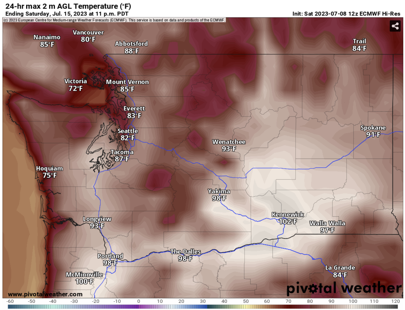
As this week goes on, there is potential for much warmer temperatures, especially next weekend and early next week. Below is the forecast for Saturday from the European model.


The European model shows a hot day on Saturday, with lowland highs in the mid to upper 80s, coastal highs in the mid 60s to mid 70s, highs from Olympia southward in the low to mid 90s, Portland area highs in the upper 90s to low 100s, and Eastern Washington’s highs in the low 90s to low 100s. This is a forecast pretty far out, but this shows the potential for hot weather in the coming days. Be sure to stay tuned!

One more note: there is a chance of severe thunderstorms for part of Washington on Monday. Below is the NWS Storm Prediction Center (SPC) outlook for Monday.


Notice the areas in dark green. That is a marginal risk of severe thunderstorms. This risk is in effect from Wenatchee to the Tri-Cities and eastward into Idaho and southward into Oregon. Remember to be very watchful when thunderstorms are possible. The biggest threats are damaging winds and brief large hail.

Finally, a look at the extended forecast from the NWS Climate Prediction Center (CPC). 

First, the temperature outlook for July 14-18.


This outlook shows a 33-50% probability of above average temperatures across Washington.

Next, the precipitation outlook for the same time (July 14-18).


For precipitation, Washington is in the middle, with a 33-40% probability of above average precipitation for extreme NE Washington, a 33-40% probability of below average precipitation for the entire southern tier of the state, and equal chances everywhere else.

Wednesday, July 5, 2023

Hot on Thursday, Warm Through the Weekend, Smoke Hangs Around

FastCast—Thursday, July 6 to Monday, July 10:

After the hottest day of 2023 so far (and first 90º+ day in Seattle) on Wednesday, another hot day is expected on Thursday, before some cooling brings temperatures down a bit with some additional cloud cover. In the lowlands, expect Thursday’s highs to reach the mid to upper 80s, with isolated highs in the low 90s and areas near the water remaining in the upper 70s to low 80s. Onshore flow will increase slightly late on Thursday, but it won’t be the heat-wave-ending marine push we’re used to. Instead, there will be a bit more cloud cover, with partly cloudy conditions on Friday and Saturday. High temperatures will drop to the upper 70s to low 80s in the lowlands, with locations close to the water staying in the mid 70s. By Sunday, temperatures will increase once more, with sunny conditions and highs back in the mid 80s. Monday looks to bring a marine push and highs dropping to the mid 70s to low 80s, with overcast conditions in the morning. Expect lows steadily in the low to mid 50s, except in the mid to upper 50s in the most densely populated areas. Additionally, smoke will remain with us through at least Thursday, with light surface smoke and smoke aloft that will bring moderate air quality (low risk to most everyone, except the most sensitive). Smoke will become more relegated to the mountains and areas downwind of local fires by Friday. There is no rain in the extended forecast, except a chance of mountain thunderstorms, which can have interesting cumulonimbus clouds that can frequently be seen across the lowlands!

(Check the bottom of the blog for a look at air quality during peak July 4th fireworks!)

————————————————————

Continue reading the full blog below!

Hot weather will continue across the state on Thursday, after Seattle recorded its first 90º+ day of 2023 on Wednesday. Let’s take a look at the forecast.

Below is the European model forecast for Thursday’s highs.


Expect lowland highs in the mid to upper 80s, with isolated areas reaching the low 90s, and areas near the water remaining in the upper 70s to low 80s. The coast will drop to the low to mid 60s, Eastern WA will scorch in the upper 80s to low 100s, and the Portland area will be hot as well, in the upper 80s to low 90s.

The lowlands will see a noticeable cooldown on Friday, as seen in the European model forecast below.


The lowlands will cool to the upper 70s to low 80s on Friday, which will be noticeably less hot than Thursday. The coast will drop a bit more into the low 60s, but notice that Eastern Washington actually gets slightly hotter, increasing into the low 90s to low 100s. The Portland area will get a bit cooler as well, with highs dropping to the low to mid 80s on Friday.

Finally, let’s take a look at Saturday’s highs, also from the European model.


Saturday’s highs are almost a carbon copy of Friday’s, with the lowlands remaining in the upper 70s to low 80s (except in the low to mid 70s near the water), the coast remaining in the low 60s, and Eastern WA remaining in the low 90s to low 100s. 

Overall, the lowlands will cool going into Saturday, as will the coast and the Portland area, and Eastern Washington will remain hot into the weekend.

Next, let’s take a look at forecast lows across the state, an important indicator of nighttime heat relief. Below is the European model forecast for lows on Thursday morning.


Expect lows in the lowlands to drop to the upper 50s to low 60s, except a bit cooler in outlying areas. Notice how warm it remains in Eastern Washington overnight, only cooling into the mid 60s to near 70º for most areas.

Let’s take a look at Friday morning’s lows as well, seen below from the European model.


Notice the lowlands are a bit cooler on Friday morning, with lows in the mid to upper 50s. Eastern WA is still quite warm, with lows only dropping to the low 60s in the north to the upper 60s to low 70s in the south.

Finally, let’s take a look at the smoke forecast. First, we’ll look at surface smoke, then smoke aloft (known as vertically integrated smoke). Below is the HRRR model forecast for surface smoke at 8 AM Thursday.


Notice light surface smoke across the entire state on Thursday morning, with the exception of the coast. Areas with surface smoke will have air quality degraded into the “moderate” category. 

Below is surface smoke by 6 PM Thursday.


Surface smoke has thinned out a bit by Thursday evening, except downwind of local fires, as seen in the graphic. As onshore flow picks up, smoke from local fires will accelerate across the region from west to east. This will be most notable around the Tunnel 5 Fire just west of White Salmon, WA, in the Columbia River Gorge. Areas east of this fire will have degraded air quality. This same effect is possible, but to a lesser extent, for areas east of the McEwan Fire (NE of Shelton), with somewhat more degraded air quality possible for areas from Shelton to Enumclaw, including Gig Harbor, Tacoma, Auburn, and Federal Way.

Finally, let’s look at smoke aloft (vertically integrated smoke), which is what causes our deep blue skies to become hazy. Below is the HRRR forecast for smoke aloft at 8 AM Thursday.


Light to moderate concentrations of smoke aloft are expected across the entire state on Thursday morning. This type of smoke has no impact on air quality, except high up in the mountains, and is more notable for obscuring the skies and limiting visibility toward the horizon.

By 6 PM Thursday, smoke aloft remains mostly the same.


Concentrations are becoming lighter on the coast, but remain similar across the rest of the state, which means a hazy day is expected on Thursday.

Remember to stay cool, stay hydrated, and monitor air quality (links under “Helpful Weather Websites” on the right side of the blog). Updated information on the Tunnel 5 Fire in the Columbia River Gorge can be found by clicking here (or here: Tunnel 5 Fire InciWeb Page).

————————————————————————

Below is a screenshot from the PurpleAir air quality map around 11:50 PM on July 4th. Notice how nearly the entire region has unhealthy to hazardous air quality (140-500+) due to smoke from fireworks.


For more information on why air quality was so bad this year, be sure to read Cliff Mass’s most recent blog post on this topic:

Cliff Mass Weather Blog: Some of the Worst Air Quality in the World Over Puget Sound: Blame Fireworks

Sunday, July 2, 2023

Hot, Dry, and Smoky for the Fourth of July

FastCast—Monday, July 3 to Friday, July 7:

A hot, dry, and smoky Fourth of July is ahead across Washington state, with a heat wave, low relative humidity, and surface smoke from British Columbia wildfires will all impact the region for the Fourth and beyond. For the lowlands, expect smoke aloft to move in on Monday, with highs in the upper 70s to low 80s. Temperatures will increase on the Fourth, with highs increasing into the mid to upper 80s. Surface smoke from British Columbia will move south into Washington early on the Fourth, and air quality will likely degrade into the “moderate” or “unhealthy for sensitive groups” categories, even before widespread fireworks smoke. Around peak fireworks time, conditions will be clear (with smoke) and temperatures will likely be in the low to mid 70s with light northerly winds. On Wednesday, temperatures will peak, with highs in the upper 80s to low 90s across the lowlands. Conditions will remain hot on Thursday, in the mid to upper 80s. Some clouds will increase in the morning on Friday, and temperatures will decrease to the upper 70s to low 80s. Low temperatures will remain in the mid 50s to low 60s, not providing much relief at night. Additionally, relative humidity will be low (20-30%) on Monday and Tuesday (and likely beyond), and fire danger is higher than normal. Keep this in mind when handling fireworks. It’s too early to tell what will happen with smoke from Wednesday onward, so stay tuned. 

—————————————————————

Continue reading the full blog below!

A hot, dry, and smoky Fourth of July is ahead for Washington state, with the potential for degraded air quality along with a heat wave. Let’s take a look at the forecast.

First, let’s take a look at the smoke forecast, starting with vertically integrated smoke (smoke aloft). All our smoke forecasts will be from the high-resolution HRRR smoke forecast. Below is the smoke forecast at 9 AM Monday.


By 9 AM Monday, smoke aloft from British Columbia will have moved into Washington, with noticeably hazy skies and a reddish tint to the sun.

Smoke aloft will continue on the Fourth (Tuesday), as seen in the forecast for 9 AM Tuesday.


Notice that smoke aloft is thicker on the Fourth across the entire state, especially in Eastern Washington.

Now for what will really be noticed…surface smoke. Just to be clear, we are not expecting the severe surface smoke that has been seen recently in New York City and Chicago. This will be much more minor, but still noticeable.

Below is the forecast for surface smoke at 9 AM Tuesday.


Light concentrations of surface smoke will cover most of the state by Tuesday morning, with heavier concentrations in the Cascades, Olympics, and in Whatcom & Skagit Counties.

Through the day, surface smoke will continue increasing across the state, as seen in the forecast for 3 PM Tuesday.


By Tuesday afternoon, as Fourth of July celebrations are ramping up, most of Western Washington will have noticeable surface smoke and degraded air quality. Surface smoke will also be noticeable in Eastern Washington, with degraded AQI expected. Expect air quality to degrade into the “moderate” to “unhealthy for sensitive groups” categories. Use the AQI forecast links on the right side of the blog to follow current measurements.

While smoke is present across the state, temperatures will be increasing as a short heat wave begins to impact the region, though smoke will likely keep temperatures below the values listed below.

Let’s take a look at the European model forecast for Monday, seen below.


On Monday, expect lowland highs in the mid 70s to low 80s, hottest south and east of Seattle. Areas from Tacoma southward will reach the low to mid 80s, the Willamette Valley will reach the upper 80s to low 90s, and the coast will reach the mid 60s to low 70s. In Eastern Washington, highs will reach the low 80s to mid 90s.

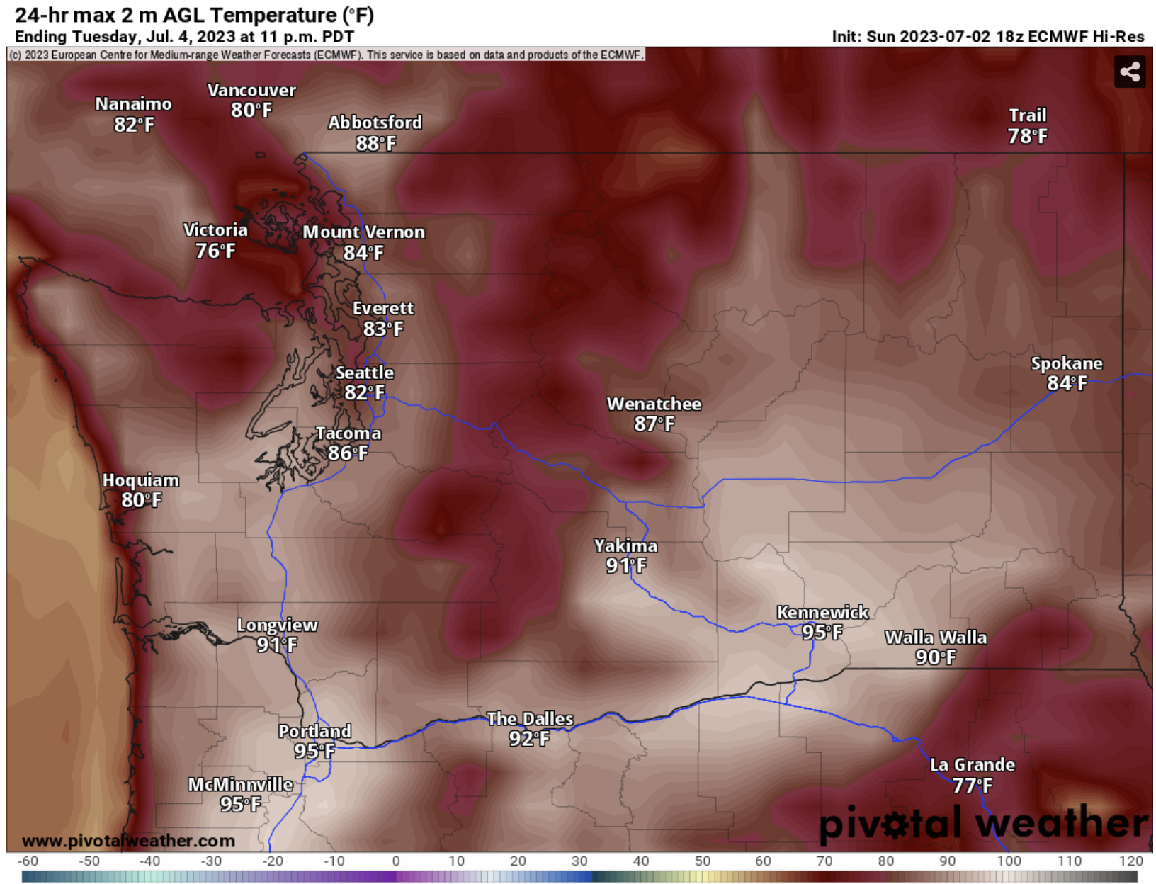
Temperatures will be even hotter on the Fourth, as seen in the European model forecast below.


Expect lowland highs in the mid to upper 80s, except in the upper 70s to low 80s near the water. From Tacoma south, highs will reach the mid 80s to low 90s, the Willamette Valley will reach the low to mid 90s, and the coast will reach the upper 60s on the beaches and low 80s inland. Eastern Washington will reach the mid 80s to mid 90s.

Wednesday will be the hottest day for areas west of the Cascades, as seen below in the European model forecast.


In the lowlands, expect highs in the mid 80s to low 90s. Highs will reach the low to mid 90s from Tacoma to Kelso, the upper 90s to low 100s in the Willamette Valley, and the upper 60s on the beaches/mid 70s inland. Eastern Washington will increase to the upper 80s to low 100s, hottest in the Columbia Basin.

In addition to the hot temperatures, nighttime lows will provide little relief from the heat. Below is the European model forecast for lows on the morning of the Fourth.


Expect Tuesday morning’s lows to only drop to the mid to upper 50s for the lowlands and Willamette Valley, the low to mid 50s on the coast, and the mid 50s to upper 60s in Eastern Washington.

Wednesday morning’s lows will be similar, as seen in the European model’s forecast below.


Wednesday morning’s lows will be even warmer, likely in the upper 50s to low 60s in the lowlands, in the low to mid 60s on the coast, and in the upper 50s to upper 60s for Eastern Washington and the Willamette Valley. Additionally, with light winds, lingering smoke from fireworks shows and private fireworks will likely linger, especially in urban areas, which will produce degraded air quality in addition to surface smoke from BC wildfires.

Finally, to add one more aspect to a hot & smoky holiday, it will also be quite dry. Below is the European model’s forecast for relative humidity at 5 PM on the Fourth.


This forecast shows relative humidity in the lowlands dropping to the 20-30% range (except on the coast, Whidbey Island, and the San Juans). Eastern Washington will be far drier, with relative humidity of 5-15%. With dry conditions, dry fuels (grasses, vegetation, etc.), and breezy northerly winds, the entire state is primed for fire starts, whether they are grass, brush, residential, or forest fires. This doesn’t even factor in the incredible fire risk posed by fireworks, so take extreme caution when burning or lighting off fireworks. It only takes one spark to start a devastating fire.

Next Storm System Hits Western Washington

  8-26 Video Briefing: Next Storm System Hits Western Washington