Saturday, July 29, 2023

Seasonable End to July Ahead

 FastCast—Sunday, July 30 to Wednesday, Aug. 2:

A seasonable end to July is ahead for Western Washington, with highs very near average (around 79º). On Sunday and Monday, expect lowland highs in the mid to upper 70s and lows in the low to mid 50s. Clouds will decrease throughout the day on Sunday, as well. A slow warming trend will begin on Tuesday, with highs increasing to the upper 70s to low 80s. Wednesday will likely be warmer, with highs further increasing to the low to mid 80s. Lows will increase to the mid 50s. Potential for more warming remains later next week, including Seafair Weekend, so stay tuned!

——————————————————

Continue reading the full blog below!

Pleasant summer weather will continue across Washington in the coming days. Let’s take a look at the forecast!

First, the European model forecast for highs on Sunday, seen below.


On Sunday, expect lowland highs in the low to mid 70s, Eastern Washington highs in the mid 80s to low 90s, and coastal highs in the mid 60s.

A similar situation will continue on Monday, as seen in the European model forecast below.


On Monday, expect lowland highs in the low to mid 70s (isolated areas in the upper 70s), Eastern Washington highs in the mid 80s to mid 90s, and coastal highs in the mid to upper 60s. There is a slight increase from Sunday in most areas.

Temperatures continue slightly increasing on Tuesday, seen in the European model forecast below.


Notice that temperatures have increased a bit more, reaching the mid 70s to low 80s in the lowlands. Eastern Washington has increased to the upper 80s to upper 90s, and the coast has increased to the mid 60s to low 70s. This looks to be the start of a slow warming trend through the first week of August.

One thing that will continue to be missing from our pattern is rain. Below is the European model forecast showing total rain through Tuesday night.


Very spotty and light areas of rain are possible, confined to the mountains and possibly a trace of drizzle along the coast. No rain is expected for the lowlands, Columbia Basin, or any other significant populated areas of Washington.

Finally, let’s take a look at the extended outlooks from the NWS Climate Prediction Center (CPC).

First, the temperature outlook for August 4-8, seen below.


This outlook shows a 50-70% probability of above-average temperatures across Washington, including the dates of Seafair Weekend. Stay tuned as we get closer!

Next, the precipitation outlook, also for August 4-8.


This is an interesting outlook, showing an equal chance of above or below average precipitation along the coast and Olympic Peninsula, and a 33-50% probability of above average precipitation for the rest of Washington. In Eastern Washington and the Cascades, this precipitation would likely be in the form of thunderstorms (or strong showers). 

Stay tuned in the coming days as we get closer to Seafair Weekend and a potential increase in temperatures!

Wednesday, July 26, 2023

Pleasant Weather Continues Across Washington

FastCast—Thursday, July 27 to Monday, July 31:

July has been relatively calm across the Northwest, with brief showers on Monday bringing July’s first rain. As we wrap up the month, pleasant weather is expected to continue. In the lowlands, expect brief morning clouds turning to afternoon sun most days. Conditions will end up being mostly sunny, with highs in the mid to upper 70s, and isolated locations reaching the low 80s. Low temperatures will remain in the mid 50s. This will be the dominant weather pattern as we end July! Stay tuned for the Seafair weekend forecast in the coming days.

——————————————————————

Continue reading the full blog below!

A nice stretch of pleasant summer weather is ahead for Washington. Let’s take a look at the forecast!

Let’s start with Thursday’s high temperatures, as forecast by the European model.


On Thursday, expect lowland highs in the mid 70s to low 80s, coastal highs in the mid 60s, and Eastern Washington’s highs in the low 80s to low 90s.

A similar pattern is ahead on Friday, also seen in the European model forecast below.


On Friday, again expect lowland highs in the mid 70s to low 80s, coastal highs in the mid 60s, and Eastern Washington’s highs in the mid 80s to mid 90s, a tad warmer than Thursday.

This run of seasonable conditions continues into the weekend, as seen in the European model’s forecast for Saturday.


Expect a slightly warmer day across the state on Saturday. Lowland highs will remain in the mid 70s to low 80s, with a higher potential for 80s around the metro area. Coastal highs will reach the mid 60s again, and Eastern Washington will warm to the upper 80s to upper 90s. 

Overall, this pattern brings seasonable and near-average temperatures to the entire state, a welcome break from heat and major fire weather concerns. However, remember that the one thing missing here is rain…which means that it’s still quite dry and fires can easily spark.

Let’s end by looking at the extended outlook from the NWS Climate Prediction Center (CPC) for the beginning of August, specifically the 3rd to 9th, which includes Seafair Weekend (5th & 6th).

First, the CPC temperature outlook for August 3-9.


The CPC shows a 50-60% probability of above average temperatures across most of Washington, except for the far northwest portions of the coast and the Northwest Interior/islands.

Next, the precipitation outlook for August 3-9.


This is a curious outlook, showing that there is an increased chance of some mountain thunderstorms and storms east of the Cascades into August, with a 33-40% probability of above average precipitation for all of the state except areas from Olympia westward and Seattle northward.

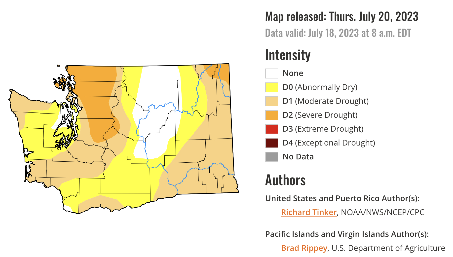
We will end this post with a graphic that will become more familiar as we progress into El Niño and toward winter…the US Drought Monitor map for Washington, released July 20th.


Make note of the drought categories on the right, as they will be important when discussing this map. The website states that 84.3% of the state is under some kind of drought. Note that most of the Cascades from King County northward and the lowlands from Skagit County northward are in “severe drought.” We’ll keep looking at this map in the coming months, as it is helpful to determine the state of drought and overall climate in Washington. Stay tuned!

Sunday, July 23, 2023

Rain Returns to Western Washington

 FastCast—Monday, July 24 to Tuesday, July 25:

The blog is back, as I have returned from a 2-week road trip around California! I’m excited to continue blogging as interesting summer weather continues. It has been 32 days since my weather station in Federal Way last reported rain, but that will likely change on Monday. A weather system will move into the region, dropping temperatures, increasing clouds, and bringing July’s first rain to Western Washington. Expect showers throughout the day. Rain will total 0.1-0.3” in the lowlands, 0.4-0.75” on the coast, and 0.9-1.5” in the Olympics and north coast. The Cascades will receive 0.3-0.5”. Eastern Washington will get no rain, due to the sharp Cascade rain shadow. A lesser rain shadow will prevail for the NE Olympic Peninsula, where rain will total a trace to 0.1”. Some residual showers are possible on Tuesday, but that is relatively unlikely. Temperatures will decrease to the upper 60s to low 70s in Western Washington and down to the mid 80s to mid 90s in Eastern Washington. Winds will increase as well, with 20-30 mph gusts in Western Washington and 30-35 mph gusts in Eastern Washington. Critically, this will increase the spread of the 51,700 acre Newell Road Fire in Klickitat County. Areas to the north and east of the fire should be on high alert for rapid fire spread. 

————————————————————

Continue reading the full blog below!

Rain is heading back to Western Washington after over a month! Plus, cooler temperatures and an increased fire threat in Eastern Washington are in store as well. Let’s take a look at the forecast!

First, the European model forecast for rain through 11 PM Tuesday.


In the lowlands, expect 0.2-0.5”, with more north of Mount Vernon (up to 0.8”). The coast will receive 0.4-1”, most from Grays Harbor northward. Notice the abrupt cutoff in rain totals east of the Cascades. It will be a challenge for Eastern Washington to get measurable rain, but some areas could squeeze out a trace.

Next, let’s compare this to the NAM high-resolution forecast, also through 11 PM Tuesday.


The NAM forecast shows much less precipitation in the lowlands from Everett south, with a trace to 0.2” in this forecast. However, it shows 0.2-0.5” from Everett north, 0.4-1.25” on the coast, and 0.5-2” in the mountains, though that’s likely overdone.

Finally, the NWS NBM forecast, also for rain through 11 PM Tuesday.


This forecast shows 0.1-0.3” in the lowlands, and 0.4-0.6” from Skagit County northward. The coast will get 0.4-1.25”, and the Cascades will get 0.4-1”. 

Overall, this won’t be a major rain event, but will be the most significant rain in months, especially in the mountains. This won’t lower fire danger in Western Washington, but it will make it harder for fires to spread (but only for a couple days). 

However, fire danger will increase in Eastern Washington, especially around the Newell Road Fire in Klickitat County. Below is the European model forecast for wind gusts on Monday afternoon.


Winds in Western Washington will gust 20-30 mph, maybe up to 35 mph in some areas. Eastern Washington will gust 30-40 mph, with winds gusting 35-40 mph around the Newell Road Fire in Klickitat County, which has burned 51,700 acres as of Sunday. Winds will be from the west/southwest, so areas north and east of the fire should be on high alert for rapid fire spread.

Finally, temperatures will significantly decrease across the state on Monday, as seen below in the European model.


Highs will decrease to the upper 60s to low 70s across the lowlands, the low 60s on the coast, and “down” to the low 80s to mid 90s in Eastern Washington. 

This is seen better in the 24-hour temperature difference forecast for 5 PM Monday, seen below from the European model.


Temperatures in Western Washington will be 5-15 degrees cooler on Monday evening than on Sunday, with 5-20 degree drops in Eastern Washington. 

For most areas, especially west of the Cascades, it will be a refreshing break from typical summer weather! Stay tuned!

Next Storm System Hits Western Washington

  8-26 Video Briefing: Next Storm System Hits Western Washington