Thursday, May 11, 2023

Very Warm Mother’s Day Weekend Ahead

 FastCast—Friday, May 12 to Monday, May 15:

A very sunny and hot Mother’s Day Weekend is ahead for the Pacific Northwest. On Friday, expect lowland highs in the mid 70s to low 80s, warmest south of Seattle. Highs will increase on Saturday to the mid 70s to mid 80s, again warmest south of Seattle. Sunday and Monday will be the hottest days, with highs north of Seattle in the upper 70s to mid 80s, and highs south of Seattle in the mid 80s to low 90s. Temperatures will be similar on Monday, with more humidity. An upper-level low full of monsoon moisture from the Desert Southwest will move into the region on Monday and Tuesday, bringing a significant chance for thunderstorms across the region (on both sides of the Cascades). There is still a good amount of uncertainty with the thunderstorm potential, so stay tuned. Additionally, gusty east winds in Eastern Washington on Saturday and Sunday, peaking at 30-40 mph, will produce a potential for dust storms. Remember, water temperatures around the region are in the upper 30s to upper 40s in lakes and rivers and upper 40s to low 50s in Puget Sound and the ocean. This shock can quickly induce hypothermia and significantly increase the risk of drowning. Water temperatures will be 30-40 degrees colder than air temperatures. Be alert and be safe!

———————————————————————

Continue reading the full blog below!

A significant May heat wave is almost upon us! High temperatures will increase through Friday and Saturday, peaking on Sunday and Monday. We will also induce a widespread chance of thunderstorms by Monday (likely continuing into Tuesday) as humid air arrives from the Southwest. There is also a decent chance that warm & dry conditions will continue through next week, so stay tuned for more on that!

Let’s start with the forecast on Friday, from the GFS model.
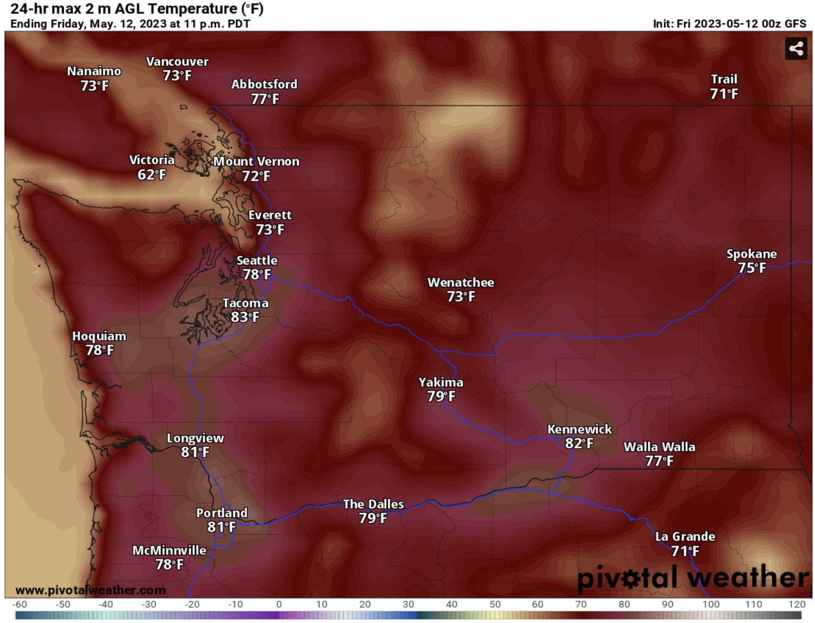

Expect lowland highs in the upper 60s to upper 70s from Seattle north, and in the upper 70s to low 80s from Seattle south. The ocean beaches will hit the upper 60s, with inland areas reaching the upper 70s to low 80s. Eastern Washington will reach the mid 70s to low 80s, warmest from I-90 south.

Let’s compare this to the NBM (National Blend of Models) forecast run by the National Weather Service, seen below.


The NBM generally agrees, with increased highs from Seattle north (to the mid/upper 70s), more isolated 80º+ from Seattle south, and highs up to the mid 80s for the Portland metro and Columbia Basin.

Next, let’s take a look at Saturday’s highs, from the GFS model.


The GFS shows lowland highs in the mid to upper 70s from Seattle north, and in the upper 70s to mid 80s from Seattle south, including inland coastal communities. The beaches will reach the low to mid 70s. The Portland metro will reach the upper 80s to near 90º, and Eastern Washington will reach the upper 70s to mid 80s.

Let’s compare this to the NBM forecast for Saturday, seen below.


The NBM is cooler for most of Western WA, likely having a hard time with the interaction of water and land (some forecast models, especially the European model, overdo cooling related to this). The NBM shows highs in the low 90s for Portland and in the upper 80s to low 90s for the Columbia Basin.

Finally, let’s take a look at Sunday (Mother’s Day), currently expected to be the hottest day of this stretch. The GFS forecast is below.


The GFS shows highs in the upper 70s to low 80s from Seattle north and in the mid 80s to low 90s from Seattle south, including inland areas of the coast. Record highs are possible. The beaches will reach the mid to upper 70s (and will be quite crowded, I’m sure!), and Eastern Washington will reach the upper 70s to mid 80s, a bit cooler due to gusty easterly winds that will increase the dust storm threat.

Let’s compare to the NBM forecast for Sunday, seen below.


Again, the NBM is overdoing the impacts of cooling breezes, but does show a more accurate depiction of highs around Portland, likely in the upper 80s to low 90s. Highs for Eastern WA are likely overdone on this forecast too, since there will be gusty winds cooling the temperatures a bit.

Speaking of winds in Eastern Washington, take a look at the European model’s forecast below for peak winds on Saturday afternoon.


Winds over the lowlands are likely too high, but 30-40 mph gusts in Eastern Washington will bring a chance of dust storms due to the abundance of fresh (and dry) soil across the countryside. Be prepared for abrupt changes in visibility, with dangerous conditions possible in strong dust storms.

You may be wondering how far above average our upcoming temperatures will be. Let’s take a look at the GFS forecast for Sunday afternoon, showing temperature departure from average across the Northwest.


The effects of downsloping easterly winds (which compress the air and bring warming) are clear in this forecast, showing temperatures reaching an incredible 20-30º above average, from Northern California all the way to British Columbia!

Now for a brief note on the upcoming thunderstorm potential…In contrast with how our heat waves typically end (with cool ocean air bringing a marine push and abruptly cooler weather), this heat wave will “end” with an upper-level low bringing monsoon moisture in from the Desert Southwest, bringing no marine cooldown and instead humid air laden with moisture, which will produce a widespread chance of thunderstorms.

Let’s take a look at how this will play out. First, the GFS forecast for Sunday morning.


Notice the massive ridge of high pressure (that will bring the heat wave) across Canada and parts of the Northwest. Then, notice the green circle, denoting the upper-level low moving north from the Desert Southwest. On Sunday, it will be over Nevada, slowly moving north.

By Monday, the upper-level low has moved north, as seen in the GFS forecast below.


Notice that my green circle noting where the system is has moved NW to Oregon and Washington. This low will bring a widespread chance of thunderstorms. On Monday, highs will likely be in the upper 70s to low 90s, and this system will bring dewpoints in the upper 50s to mid 60s, which is quite muggy and relatively rare here. This combination will cause significant instability across the region, promoting a potential for thunderstorms. However, details aren’t too certain, so stay tuned in the next few days.

One quick note at the end of the blog. As I mentioned in the FastCast, there is a very high danger of shock and hypothermia if you are recreating in area waterways. The very helpful infographic below from NWS Seattle shows the dangers of cold water. (Click on it to zoom in)


As the graphic says, “the air may be hot, but the water is cold!” Remember, water temperatures are 30-40 degrees below air temperatures, and the rapid transition can be deadly. Be safe out there!

Stay tuned for updates on the blog and on my Twitter page (link at right side of blog)!

Tuesday, May 9, 2023

Heat Wave Forecast Update

FastCast—Wednesday, May 10 to Sunday, May 14:

A rare May heat wave is beginning to build. Highs will increase to the low to mid 70s across the lowlands on Wednesday and Thursday, with mostly sunny conditions on Wednesday and partly sunny conditions from late Wednesday to Friday. Highs on Friday will increase to the upper 70s to low 80s, then will increase even more on Saturday, likely in the upper 70s to mid 80s. Sunday (Mother’s Day) will be quite hot, with lowland highs reaching the mid 80s to low 90s. On all these days, subtract 3-5 (or more) degrees from highs if you’re near the water. Expect lows in the mid to upper 40s through Thursday, then in the low to mid 50s on Friday and Saturday, and finally increasing to the upper 50s to low 60s on Sunday. Hot conditions will likely continue on Monday and Tuesday, but that is a more uncertain forecast due to the potential for monsoon moisture moving north from the Desert Southwest, which may induce a potential for muggier conditions and possible thunderstorms. Remember that local water temperatures are in the upper 30s to mid 40s (rivers & lakes) to upper 40s/low 50s (Puget Sound & Pacific Ocean). This means that water temperatures are 30-50º below air temperatures. Beware of this when recreating in any bodies of water during this heat wave.

———————————————————

Continue reading the full blog below!

A May heat wave with potential record-breaking temperatures is ahead. Let’s take a look at the forecasts.

First, the GFS forecast for Wednesday’s highs (Thursday will be similar…but add 1-3º).


Expect lowland highs in the mid 60s to mid 70s on Wednesday and Thursday, with coastal highs in the low 60s to low 70s (warmer inland), and highs in Eastern WA in the mid 60s to mid 70s.

Next, the highs for Friday, also from the GFS model.


By Friday, lowland highs will increase to the mid 70s to low 80s, hottest from Seattle southward. The coast will reach the mid 60s to mid 70s, and Eastern WA will reach the mid 70s to low 80s.

As the next GFS graphic shows, highs will increase even more on Saturday to begin Mother’s Day Weekend.


On Saturday, expect lowland highs in the mid 70s to low 80s north of Seattle and in the low to mid 80s south of Seattle. Areas near Portland could reach the upper 80s. Expect the coast to reach the low to mid 70s on the beaches and the low to mid 80s inland. Eastern Washington will reach the upper 70s to mid 80s.

Sunday (Mother’s Day) is currently forecast as the hottest day. We will look at more forecasts for Sunday in future blogs, but below is the GFS forecast.


In the lowlands, expect highs in the upper 70s to mid 80s north of Seattle and in the mid 80s to low 90s south of Seattle and into Portland. The ocean beaches will peak in the upper 70s to mid 80s, and inland coastal communities will reach the upper 80s to low 90s. Since the “thermal trough” that brings the highest heat will be west of the Cascades, Eastern WA will be slightly cooler, in the low to mid 80s.

To end the blog, we will take a look at the consensus between the two main global models, the European and GFS, showing that a massive ridge of high pressure is expected by the weekend.

First, below is the GFS forecast for late Saturday. 


Notice the massive ridge of high pressure extending from the Pacific Northwest into Northern Alberta and Saskatchewan. That will allow the “thermal trough” to build along the West Coast, bringing hot conditions from Saturday through early next week.

Let’s compare this with the European model’s forecast, also for late Saturday.


Wow! The European and GFS are nearly identical (somewhat rare these days), with the European also showing a massive ridge stretching from the Pacific Northwest into the Canadian Shield.

Stay tuned for more information in the coming days, as details get refined for the hottest temperatures and as we monitor the potential for monsoon moisture from the Desert Southwest potentially moving in early next week. 

Sunday, May 7, 2023

Major Warmup Ahead, Summer-Like Heat Possible by Mother’s Day

FastCast—Monday, may 8 to Sunday, may 14:

After a few months of mainly below-average temperatures, a significant change is ahead. Before we get to that…a quick note that there is a chance of showers around the region through Tuesday, with 0-0.15” possible in the lowlands and 0.1-0.4” possible in Eastern Washington. Some showers in Eastern Washington could develop into thunderstorms. Now for the real weather news…a massive ridge of high pressure will build over the Pacific Northwest and Western Canada. This ridge will increase through the week, peaking by Mother’s Day Weekend and the beginning of next week. Highs in the lowlands (only the lowlands in the FastCast…keep reading below for more) will start out in the low to mid 60s on Monday and Tuesday, with lows in the mid to upper 40s. Wednesday and Thursday will see an increase into the low to mid 70s, with lows in the upper 40s. The real heat begins on Friday, with highs in the upper 70s to low 80s, and lows in the low 50s. It will feel like hot summer days for Mother’s Day Weekend, with highs likely reaching the mid 80s to low 90s, with lows in the upper 50s to low 60s. This week will be a mix of sun and clouds, with partly cloudy conditions on Monday, Thursday, and Friday; mostly cloudy conditions on Tuesday, and sunny conditions on Wednesday, Saturday, and Sunday. Many details about this upcoming heat wave are yet to be determined, so stay tuned for more information this week. 

————————————————————

Continue reading the full blog below!

A major weather change is ahead, with a massive high pressure ridge expected to build over the Pacific Northwest and Western Canada. This ridge will bring sunnier, drier, and hotter conditions to the region. Let’s take a look at the forecast.

Let’s start with the European model forecast showing the high pressure ridge late next Sunday, at its peak.


Notice the massive area of high pressure over the Northwest. Although the ridge itself is centered just north of our region, this allows hotter conditions across WA & OR.

Below is the GFS forecast showing the high pressure ridge by next Sunday, at its peak.


The European and GFS agree on a strong & large ridge building over the Northwest by next weekend. This will bring a significant round of warmer weather to the region.

Let’s take a look at the highs this week, from the GFS model. First, highs on Monday, seen below.


On Monday, expect highs in the low to mid 60s in the lowlands, the upper 50s to low 60s on the coast, and in the low 60s to low 70s in Eastern Washington, hottest near the Tri Cities. Tuesday’s highs will be similar to these.

Next, let’s look at Wednesday’s highs, also from the GFS model.


On Wednesday, expect highs in the mid 60s to mid 70s in the lowlands, in the low to mid 60s on the coast, and in the mid 60s to mid 70s in Eastern Washington. Highs will be similar on Thursday.

Next, the highs for Friday, from the GFS model.


Expect Friday’s highs to be in the low 70s to low 80s in the lowlands, in the mid 60s to mid 70s on the coast, and in the mid 70s to low 80s in Eastern Washington. 

By Mother’s Day (Sunday), forecasts show that summer-like heat will build. There is still some uncertainty as to how hot it will get and the exact timing of this heat. However, it is likely to be hot this upcoming weekend. Below is the GFS forecast for highs on Mother’s Day.


What a huge warmup! Per this forecast, highs could reach the low 80s to low 90s in the lowlands, the mid 70s to low 90s on the coast (warmer inland), the mid 80s to low 90s in Eastern Washington, and the low to mid 90s from Olympia south through Portland.

What about the extended forecast? The NWS Climate Prediction Center temperature outlook for May 13-17 is below.


This outlook shows a 60-80% probability of above average temperatures across the Pacific Northwest through mid-May. Precipitation is expected to be near or below normal.

There is still uncertainty regarding the fine details of the upcoming warmup and heat wave, but hot temperatures are looking likely. Stay tuned this week for more information!

Next Storm System Hits Western Washington

  8-26 Video Briefing: Next Storm System Hits Western Washington