FastCast—Monday, may 8 to Sunday, may 14:
After a few months of mainly below-average temperatures, a significant change is ahead. Before we get to that…a quick note that there is a chance of showers around the region through Tuesday, with 0-0.15” possible in the lowlands and 0.1-0.4” possible in Eastern Washington. Some showers in Eastern Washington could develop into thunderstorms. Now for the real weather news…a massive ridge of high pressure will build over the Pacific Northwest and Western Canada. This ridge will increase through the week, peaking by Mother’s Day Weekend and the beginning of next week. Highs in the lowlands (only the lowlands in the FastCast…keep reading below for more) will start out in the low to mid 60s on Monday and Tuesday, with lows in the mid to upper 40s. Wednesday and Thursday will see an increase into the low to mid 70s, with lows in the upper 40s. The real heat begins on Friday, with highs in the upper 70s to low 80s, and lows in the low 50s. It will feel like hot summer days for Mother’s Day Weekend, with highs likely reaching the mid 80s to low 90s, with lows in the upper 50s to low 60s. This week will be a mix of sun and clouds, with partly cloudy conditions on Monday, Thursday, and Friday; mostly cloudy conditions on Tuesday, and sunny conditions on Wednesday, Saturday, and Sunday. Many details about this upcoming heat wave are yet to be determined, so stay tuned for more information this week.
————————————————————
Continue reading the full blog below!
A major weather change is ahead, with a massive high pressure ridge expected to build over the Pacific Northwest and Western Canada. This ridge will bring sunnier, drier, and hotter conditions to the region. Let’s take a look at the forecast.
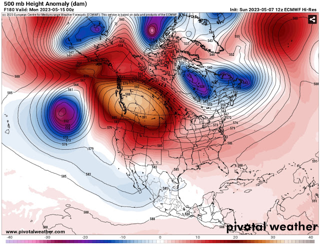
Let’s start with the European model forecast showing the high pressure ridge late next Sunday, at its peak.
Notice the massive area of high pressure over the Northwest. Although the ridge itself is centered just north of our region, this allows hotter conditions across WA & OR.
Below is the GFS forecast showing the high pressure ridge by next Sunday, at its peak.
The European and GFS agree on a strong & large ridge building over the Northwest by next weekend. This will bring a significant round of warmer weather to the region.
Let’s take a look at the highs this week, from the GFS model. First, highs on Monday, seen below.
On Monday, expect highs in the low to mid 60s in the lowlands, the upper 50s to low 60s on the coast, and in the low 60s to low 70s in Eastern Washington, hottest near the Tri Cities. Tuesday’s highs will be similar to these.
Next, let’s look at Wednesday’s highs, also from the GFS model.
On Wednesday, expect highs in the mid 60s to mid 70s in the lowlands, in the low to mid 60s on the coast, and in the mid 60s to mid 70s in Eastern Washington. Highs will be similar on Thursday.
Next, the highs for Friday, from the GFS model.
Expect Friday’s highs to be in the low 70s to low 80s in the lowlands, in the mid 60s to mid 70s on the coast, and in the mid 70s to low 80s in Eastern Washington.
By Mother’s Day (Sunday), forecasts show that summer-like heat will build. There is still some uncertainty as to how hot it will get and the exact timing of this heat. However, it is likely to be hot this upcoming weekend. Below is the GFS forecast for highs on Mother’s Day.
What a huge warmup! Per this forecast, highs could reach the low 80s to low 90s in the lowlands, the mid 70s to low 90s on the coast (warmer inland), the mid 80s to low 90s in Eastern Washington, and the low to mid 90s from Olympia south through Portland.
What about the extended forecast? The NWS Climate Prediction Center temperature outlook for May 13-17 is below.
This outlook shows a 60-80% probability of above average temperatures across the Pacific Northwest through mid-May. Precipitation is expected to be near or below normal.
There is still uncertainty regarding the fine details of the upcoming warmup and heat wave, but hot temperatures are looking likely. Stay tuned this week for more information!


Now we will be saying "It is too hot"!
ReplyDelete