FastCast—Saturday, May 20 to Tuesday, May 23:
After a brief incursion of Alberta smoke to the Pacific Northwest, a cooldown and return to more seasonable weather is expected. However, there is first a chance of thunderstorms across the region, with a potential for severe thunderstorms in Eastern Washington & Oregon on Saturday and Sunday. There is a chance of thunderstorms in the lowlands from late Friday night through early Saturday morning, though this chance isn’t represented too well in most forecasts. Saturday will be partly sunny in the lowlands, with highs in the mid to upper 70s and lows in the upper 50s. Sunday will bring dramatic change across the state (more on that below), and the lowlands will have overcast skies, with highs in the mid 60s and lows in the mid to upper 40s, a large and refreshing change from the past week of warmer temperatures. There is also a chance of light showers on Sunday, with the most likely scenario being a trace to 0.2” of rain in more concentrated areas of showers. Expect drier and partly to mostly cloudy conditions on Monday and Tuesday, with highs in the mid to upper 60s and lows in the mid to upper 40s.
——————————————————
Continue reading the full blog below!
Before a return to more seasonable temperatures and cloudier conditions, another area-wide chance of thunderstorms is ahead, with severe thunderstorms possible in Eastern Washington and Oregon. Let’s take a look at the forecast.
Let’s start with the instability forecast for 3 AM Saturday from the UW WRF model.
The UW forecast shows CAPE of 800-1200 over the Cascades and Western Washington very early Saturday morning. This means that there is a potential for thunderstorms. As of 11 PM, some storms have already popped up on radar in the foothills of Snohomish and Pierce Counties. Fast-moving thunderstorms are possible overnight and into early Saturday morning. Any storms that do develop will bring brief lightning, possible brief heavy rain, and gusty winds. Storms will move quickly from south to north.
Instability and other key ingredients for thunderstorms will remain present on Saturday and Sunday east of the Cascades. This will produce a severe thunderstorm risk for eastern parts of Washington and Oregon this weekend. Below is the Storm Prediction Center (SPC) outlook for Saturday.
Notice the large dark green region indicating a marginal risk of severe thunderstorms from South-Central Oregon along the east slopes of the Cascades into British Columbia. The biggest threats with these storms are localized 60+ mph wind gusts and brief 1+ inch hail.
The SPC outlook for Sunday shows the continuation of favorable conditions for severe thunderstorms across the Inland Northwest.
Sunday’s risk area is further east, and includes WA’s far eastern tier, the eastern third of Oregon, most of Western ID and the panhandle, and far western Montana. This risk area also includes larger population centers such as Spokane, Coeur d’Alene, Boise, Missoula, and Lewiston.
Again, the biggest threats will be severe wind gusts (60+ mph) and severe hail (1+ inch).
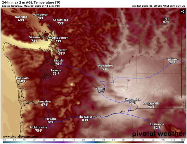
Sunday will also bring a major cooldown for the region. First, let’s take a look at what to expect on Saturday. Below is the high-resolution NAM forecast for high temperatures on Saturday.
Expect highs in the mid to upper 70s in the lowlands (cooler near the water, especially in the North Sound), in the mid 50s to low 60s on the coast, and sweltering in the upper 80s to upper 90s in Eastern Washington, hottest in the lower Columbia Basin.
Quite a change is in store for Sunday, as a trough replaces the dominant ridge. Below is the NAM forecast for Sunday.
Highs in the lowlands will drop to the upper 50s to low 60s, and the coast will drop down to the mid to upper 50s. Eastern Washington will also cool significantly, down to the upper 70s to low 80s.
What will the 24-hour temperature difference be? Take a look below at the NAM forecast for 24-hour difference at 3 PM Sunday.
The NAM shows 10-20º of cooling across the state, most pronounced in the lowlands, mountains, and Eastern WA. Sunday will bring a return to more seasonable temperatures across the Northwest.
Finally, as a trough moves in on Sunday, there is a chance for light showers in the lowlands. Below is the NAM forecast for precipitation through 5 AM Monday.
Notice 0.1-0.25 inches of rain on the coast, heaviest in showers. The lowlands will have areas of showers bringing a trace to 0.25” of rain, heaviest in a possible Convergence Zone between Seattle and Everett. The Cascades and Eastern WA will have sporadic and hard-to-predict precipitation amounts, since rain will only be confined to thunderstorms. Any storms that do develop could bring rapid heavy rain (up to 1” in the strongest storms), with the potential for flash flooding.
Be aware if you are in thunderstorm risk areas. Storms can develop quickly and without much warning. Enjoy a final “warm” day in the lowlands on Saturday!


No comments:
Post a Comment