FastCast—Sunday, May 14 to Wednesday, May 17:
The hottest days of this heat wave are ahead on Sunday and Monday. Highs in Western Washington will reach the mid 80s to low 90s, cooler near the water and north of Everett. Overnight lows will only drop into the upper 50s to mid 60s, far warmer than we typically experience at this time of year. Monday will not only be hot, but also humid. An upper-level low moving in from the Desert Southwest will bring increased moisture into the atmosphere, bringing an increased chance of thunderstorms across Washington state, especially from Monday afternoon into the night and again on Tuesday afternoon and into the night. Monday looks to have the best conditions for thunderstorm development. For more about the potential for thunderstorms, keep reading below. Much warmer than average temperatures will continue on Tuesday, with partly cloudy conditions and highs in the upper 70s to low 80s. Another round of potential heat looks to build starting around Wednesday, with lowland highs increasing back to the low to mid 80s (cooler near water & north of Everett). Expect overnight lows to continually be in the upper 50s to low 60s, with some urban areas not cooling below the mid 60s. Remember, water temperatures are 30-50º below air temperatures. Take significant safety precautions if you are planning to recreate in the water during this heat wave!
————————————————————
Continue reading the full blog below!
A dynamic couple days of weather are ahead for Washington state, with significant heat, potential thunderstorms, and interesting local weather features in the forecast.
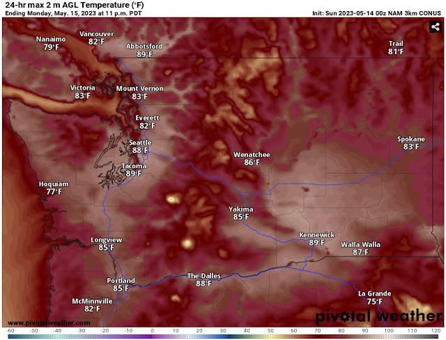
Let’s start with the NAM high-resolution forecast for Sunday’s highs, seen below.
The NAM shows highs in the lowlands reaching the mid to upper 80s, except cooler (upper 70s to low 80s) near the water. Some locations may reach the low 90s. Offshore flow will bring hot temperatures to the ocean beaches, with highs in the upper 70s to mid 80s. Eastern Washington will also be warm, with highs in the low 80s to low 90s, warmest in the Columbia Basin.
Note: Although not shown in this blog, Sunday morning’s lows will be on the warm side, only dropping to the upper 50s to mid 60s, with isolated urban spots staying in the upper 60s.
One important aspect about Sunday’s conditions will be the breezy easterly (offshore) winds that will be present in some areas. Below is the NAM wind gust forecast at 10 AM Sunday.
Notice the gusty offshore flow, including traditional “gap winds” near Enumclaw/Tacoma and Portland. Parts of Eastern Washington will gust 25-35 mph, bringing a potential for areas of blowing dust and reduced visibility.
In Western WA & OR, these offshore (downslope) winds will compress and warm the air, increasing high temperatures.
Next, let’s take a look at the NAM forecast for Monday’s highs, seen below.
The NAM shows another hot day on Monday, with lowland highs in the mid to upper 80s, except in the low 80s near the water. Isolated locations will reach the low 90s. Offshore flow will be weaker on Monday, as seen by the fact that the coast will cool from the upper 70s to mid 80s down toward the mid 70s to low 80s, with the warmest temperatures north of Hoquiam. Eastern Washington will likely reach the mid 80s to low 90s.
Monday’s weather situation will be more complicated than Sunday. An upper-level low will approach the Northwest from the Desert Southwest, and will advect monsoon moisture northward into the region. This will bring an increase in humidity (making it feel muggier) and a far more unstable atmosphere, increasing the chance of area-wide thunderstorms.
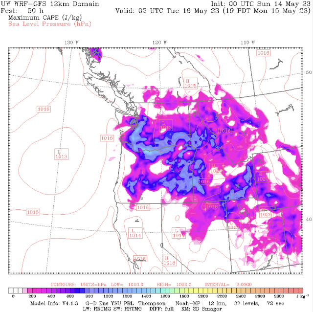
Below is the UW forecast for CAPE (Convective Available Potential Energy, aka amount of instability in the atmosphere) at 7 PM Monday.
Notice widespread CAPE across the Northwest, with potentially very high values of 1000-1500 across the lowlands, the southern tier of WA/northern tier of OR, parts of Eastern OR, and areas of Idaho.
Paying attention to the increased CAPE over the lowlands, you can tell that the atmosphere will be primed for thunderstorms, with far more instability than usual (normal CAPE values here are in the 100-300 range).
Additionally, it will be quite muggy, with dewpoints (temperature where water condenses, forming dew, and a measure of mugginess), significantly higher than typical for this time of year. Below is the NAM forecast for dewpoints at 7 PM Monday.
Notice high dewpoints in the low to mid 60s across the lowlands and Willamette Valley. This will be noticeable outside and will contribute to the increased thunderstorm potential.
Again, the best chances for thunderstorms will be from Monday afternoon into the night, with most storms being high-based, meaning that their cloud base is high and they don’t produce as much precipitation.
However, with details still uncertain, stay tuned to the blog & my Twitter. I will have a blog update by Sunday night.


No comments:
Post a Comment