FastCast—Wednesday, May 17 to Sunday, May 20:
With the hottest temperatures and most widespread thunderstorms behind us, a few more “hot” days are ahead for Western Washington before a return to more seasonable temperatures by Sunday. On Wednesday and Thursday, expect hot temperatures, with lowland highs in the low to mid 80s, with colder temperatures near the water. Lows will remain on the warmer side, likely in the upper 50s to low 60s. Temperatures drop a bit on Friday and Saturday, with lowland highs in the upper 70s to low 80s, and lows in the mid to upper 50s. Clouds will be around on Friday morning and then will increase through Saturday. Conditions look to return to seasonable normals by Sunday for the lowlands, with highs in the upper 60s to low 70s, lows in the low 50s, and mostly cloudy conditions. For the entire period, expect partly to mostly cloudy conditions, highs in the low to mid 60s, and lows in the low 50s on the coast. Eastern Washington will be getting hotter through Saturday, with highs in the mid 80s to upper 90s and lows in the mid to upper 60s. Thunderstorms are possible in the Cascades and across Eastern Washington through the end of the week and into the weekend. Remember to use caution if recreating and be aware when driving. Pay extra attention if you are around burn scar areas during thunderstorms, as there is a higher chance of flash flooding.
————————————————————
Continue reading the full blog below!
For many, Tuesday brought relief from the summer-like heat experienced in the past few days. Another round of warmer temperatures is ahead before a gradual cooldown this weekend. Let’s take a look at the temperature forecast.
Below is the NAM high-resolution forecast for Wednesday’s highs.
This forecast was 1-4º too cold for the lowlands on Tuesday, so knowing that, expect lowland highs in the upper 70s near the water to the mid 80s inland. Highs on the coast will only be in the low to mid 60s. Eastern Washington will have highs in the low 80s near Spokane and the mid to upper 80s for the rest of the region.
Temperatures will be warmer on Thursday, as seen in the NAM forecast below.
This forecast shows Thursday’s highs in the mid 70s north of Everett and in the low 80s south of Everett, but this is likely underdone. The coast will only reach the upper 50s to low 60s. This forecast also shows Eastern Washington reaching the mid 80s to low 90s.
Perhaps a better representation of Thursday’s highs is found from the European model’s forecast. Wednesday’s highs may be similar to these in the lowlands.
The European model shows highs in the mid 70s to low 80s from Everett northward and in the low to mid 80s from Everett south. The coast will likely reach the upper 50s to mid 60s, and Eastern Washington will reach the low 80s to mid 90s, hottest from I-90 southward.
Thunderstorms will continue to be possible on Wednesday and Thursday, mainly over the mountains. Let’s take a look at the instability (CAPE) forecast for Wednesday evening from the UW WRF model.
On Wednesday evening, notice the high instability (CAPE values of 800-1500) over the Olympics and Cascades, plus the North Cascades and areas near Spokane. There are also high CAPE values over Vancouver Island’s central mountains.
The same general situation is expected on Thursday evening, and the UW WRF forecast is below.
On Thursday, instability is relegated to the Cascades, with CAPE values in the 800-1700 range.
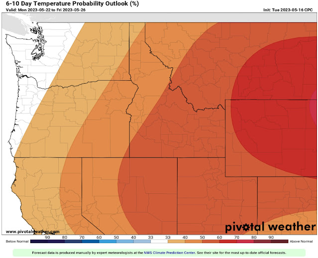
Finally, let’s take a look at the extended forecast outlooks from the NWS Climate Prediction Center. First, let’s take a look at the temperature outlook for next Monday to Friday.
This outlook shows an equal probability of above or below normal temperatures for Western Washington, with a 33-50% probability of above average temperatures in Eastern Washington. (Keep in mind…“normal” temperatures in May are in the mid to upper 60s).
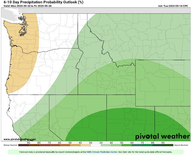
Next, let’s take a look at the precipitation outlook for next week, also from the CPC.
Expect a 33-40% probability of below average precipitation for Western WA & OR, with an equal chance of above or below average precipitation for Eastern Washington, and a 33-50% probability of above average precipitation for extreme SE Washington and most of Idaho and far eastern Oregon, due to the Southwest monsoon.
Above-average temperatures are expected to continue through the end of this week! Enjoy the sun!


No comments:
Post a Comment