No FastCast today…just a brief update on Alberta wildfire smoke.
I’m sure everyone noticed the significant haze over the region on Wednesday and now on Thursday, which has produced very red sunrises and sunsets and a bit of an orange tint to the sun. This is due to smoke from large wildfires burning in Alberta, Canada (the province to the east of British Columbia).
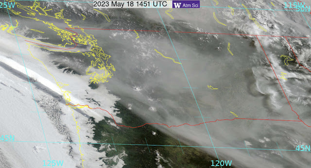
The 8 AM satellite image from UW Atmospheric Sciences shows the smoke across Washington.
The smoke is quite noticeable across most of the state, along with marine stratus clouds that made their way inland to parts of the Kitsap Peninsula overnight.
Is this smoke impacting air quality? Let’s take a look at the 8 AM readings from the PurpleAir AQI map.
Notice that air quality remains “good” across the majority of Washington, with “moderate” to “unhealthy for sensitive groups” in parts of northern and far eastern Washington. Air quality is far worse over British Columbia, Alberta, and Montana.
So, how long will the smoke last? Let’s take a look at the RAP-Smoke Model to find out.
We will start with vertically-integrated smoke (aka smoke aloft). Below is the RAP-Smoke forecast for 10 AM Thursday.
At 10 AM, the heaviest haze is beginning to move out of Western Washington, with heavy smoke aloft across most of Eastern Washington, and generally across the entire northern United States.
Next, let’s take a look at 4 PM Thursday.
By 4 PM, the smoke has made progress moving out of Western Washington, with only light concentrations remaining. However, heavy smoke aloft is present from Eastern Washington all the way to the Mid-Atlantic, with the heaviest smoke over parts of the High Plains and Upper Midwest.
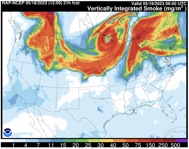
Finally, let’s look at 2 AM Friday.
By 2 AM, the heaviest smoke is concentrated east of the Cascades. Notice the heavy smoke aloft over New England. There will be some smoky sunrises across the country on Friday.
Now, let’s shift gears and look at near-surface smoke, also from the RAP-Smoke model. Near-surface smoke is what will impact air quality.
Let’s start with near-surface smoke at 10 AM Thursday.
Because this smoke is aloft, the areas with the highest chance for degraded air quality will be in the Cascades, Rockies, and areas where smoke has mixed down to the surface. At 10 AM, this is most likely in far northern and eastern WA, the northern half of Idaho, and eastward to Nebraska, Minnesota, and NE Iowa.
Let’s skip forward to 4 PM Thursday.
By 4 PM Thursday, concentrations of near surface smoke are found from the Cascades eastward, with degraded air quality likely in Eastern Washington and in Central & Northern Idaho.
Finally, let’s take a look at 2 AM Friday.
By 2 AM, degraded air quality remains across most of Eastern Washington (with lighter concentrations of smoke from the Tri-Cities westward) and most of Idaho, essentially on a line from Boise to Pocatello northward. Other areas of degraded air quality will remain present across the Plains and Midwest, as far south as Kansas.
One benefit of the smoke aloft over Western Washington is that it provides fiery red and orange sunsets. Take a look at this photo I took last night in Federal Way at sunset!


Thanks for the update, Matthew!
ReplyDelete