FastCast—Friday, May 5 to Monday, May 8:
A rainy and chilly day (by May standards) is ahead on Friday. While forecast precipitation has decreased from previous estimates, it will still be quite a rainy day, especially from Seattle north and east. Generally, expect 0.25-0.75” from Seattle southward to Portland, except totals of 0.1-0.25” around Olympia. The coast will receive 0.1-0.3”, with isolated higher totals. Areas from Seattle northward and in the foothills will receive 0.5-1.25”, with isolated higher totals, mainly in the foothills. Expect showers to continue at times from Saturday to Monday, bringing an additional 0.1-0.2” of rain across the region. High temperatures on Friday will be colder than normal, only reaching the upper 40s to low 50s in the lowlands and the mid 50s to low 60s in Eastern Washington. For the weekend and Monday, lowland highs will increase into the upper 50s to low 60s. Lows throughout the period will be in the mid 40s.
———————————————————
Continue reading the full blog below!
A rainy and chilly Friday is in store across the lowlands. Let’s take a look at the forecast.
Below is the European model forecast for rain through 11 AM Saturday.
The European model forecast shows 0.75-1.25” from Seattle northward and in all the Cascade foothills, 0.5-1” from Seattle southward (except 0.1-0.3” around Olympia), 0.4-0.8” on the coast, and 0.1-1” in Eastern Washington, with more sporadic totals due to showery precipitation.
Next, let’s take a look at the high-resolution NAM forecast, showing total rain through 11 AM Saturday.
The NAM shows a different picture than the European. This forecast shows 0.5-1.25” for Seattle northward, 1.25-2.5” in the foothills, 0.75-2” for the northern and far eastern parts of Eastern WA, and a trace to 0.5” from Seattle south, with a sharp cutoff around Federal Way. The coast would get 0.1-0.25”.
Lastly, the high-resolution UW WRF forecast for total rain through 5 PM Saturday (Western WA only).
The UW forecast shows 0.5-1.5” from Seattle northward and in the foothills, 0.25-0.5” from Seattle to Olympia, and 0.1-0.2” from Olympia southward and on the coast.
This rain will cause rivers to rise somewhat, mainly north of I-90. Some rivers draining the east slopes of the Cascades will near bankfull or minor flood stage, particularly the Naches and Yakima Rivers, cresting on Saturday.
Friday will also be noticeably chillier than previous days. Below is the GFS forecast for high temperatures on Friday.
This will be quite a chilly day for May. Expect highs only in the upper 40s to low 50s for Western Washington, and in the mid 50s to low 60s in Eastern Washington.
This will be a large 24-hour temperature decline in Eastern WA, as seen in the GFS forecast below for 24-hour temperature difference at 5 PM Friday.
Expect most of Eastern Washington to be 15-30º colder than Thursday, with areas from Tacoma northward being 1-7º colder than Thursday.
Finally, a look at the extended forecast outlooks from the NWS Climate Prediction Center, valid for May 12-18 (next Friday to mid-May).
First, the temperature outlook for May 12-18, below.
For May 12-18, there is a 50-70% probability of above average temperatures.
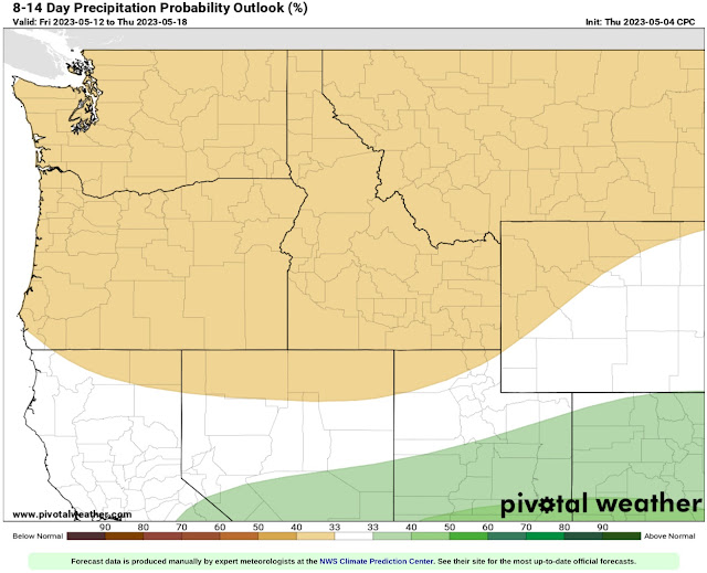
Next, the precipitation outlook for May 12-18, seen below.
This outlook calls for a 33-40% probability of below average precipitation for May 12-18.
Forecasts are indicating the potential for warmer conditions beginning around the middle of next week. Additionally, some thunderstorms remain possible across the northern and eastern portions of Washington through early Friday.


Yes you are right, I have rain at my house, and have a feeling it will be here all day.
ReplyDelete