FastCast—Wednesday, May 24 to Saturday, May 27:
After a few cooler days with the stronger influence of marine air, sunnier and warmer conditions are ahead through the end of the week and into the weekend. On Wednesday, expect mostly sunny conditions in the lowlands, with highs in the upper 60s to low 70s and lows in the mid 40s. Temperatures will continue to rise in the lowlands on Thursday and Friday, with highs reaching the upper 70s to low 80s, except colder near the water. Lows will be in the mid 50s. Temperatures will decrease on Saturday, as clouds increase, dropping highs to the mid 70s. No rain is expected through the weekend!
————————————————————
Continue reading the full blog below!
After a few cooler days, highs will be on the rebound in the second half of this week. Let’s take a look at the forecasts! We will examine the GFS and NAM forecasts, which each show a slightly different forecast.
We will start below with the NAM forecast for highs on Wednesday.
The NAM shows highs in the mid to upper 60s in the lowlands, upper 50s to low 60s on the coast, and upper 60s to upper 70s in Eastern Washington.
The GFS forecast for Wednesday, seen below, is warmer.
The GFS shows highs in the lowlands in the mid 60s to mid 70s, in the upper 50s to mid 60s on the coast, and the upper 60s to upper 70s in Eastern Washington, similar to the NAM.
Next, let’s take a look at Thursday, starting with the NAM forecast.
It’s a noticeable increase from Wednesday to Thursday. Lowland highs will increase to the low to mid 70s, the coast will increase to the upper 50s to low 70s (warmest off the beaches), and Eastern Washington will increase to the mid 70s to mid 80s.
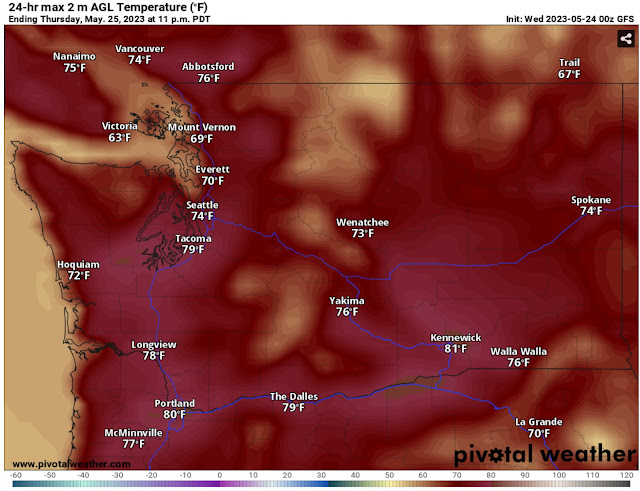
Let’s compare this to the GFS forecast for Thursday.
The GFS shows lowland highs increasing to the upper 60s-low 70s north of Seattle, and mid to upper 70s south of Seattle. It also shows highs in the low 60s to low 70s, and Eastern Washington in the mid 70s to low 80s.
Finally, a look at Friday, which will likely be the hottest day of this brief warmup. We will start with the NWS NBM model (NAM doesn’t reach this far out).
The NWS NBM forecast shows lowland highs in the mid to upper 70s, the coast in the mid 60s, and the Willamette Valley and Eastern Washington in the upper 70s to mid 80s.
Let’s compare this with the warmer GFS forecast for Friday, seen below.
The GFS forecast shows a far warmer situation for the lowlands, with highs on Friday reaching the mid 80s from Seattle to Olympia. This is somewhat unlikely, but is within the realm of possibilities. This forecast shows mid 60s on the coast and upper 70s to mid 80s for the Willamette Valley and Eastern Washington.
Finally, let’s take a look at the extended forecast outlooks from the NWS Climate Prediction Center (CPC).
First, let’s look at the temperature outlook for May 29-June 2.
There is roughly a 33-60% probability of above-average temperatures in Washington, increasing as you go east, with extreme Western WA having an equal chance of above or below average temperatures.
Next, let’s look at the precipitation outlook for May 29-June 2, also from the CPC.
There is a 33-50% probability of below average precipitation from the Cascades westward, an equal chance of above or below average precipitation for most of Eastern Washington, and a 33-40% probability of above average precipitation for extreme SE Washington.
Stay tuned for a look at the Memorial Day Weekend forecast on Thursday night!


No comments:
Post a Comment