Monday, June 5, 2023

Significant Warmup Ahead

FastCast—Tuesday, June 6 to Saturday, June 10:

A significant warmup is ahead for Washington state from Tuesday to Thursday. On Tuesday, expect lowland highs to increase into the mid 70s to low 80s. Wednesday will be by far the hottest day, with highs in the upper 70s to low 80s near the water and in the mid to upper 80s elsewhere. There is a slight chance of highs reaching the low 90s for isolated locations in the lowlands, most likely closer to the foothills. Thursday will still be warm, but with increasing high clouds and highs dropping to the mid 70s to low 80s, with some readings in the mid 80s. Throughout this time, expect lows in the low to mid 50s. Additionally, due to recent dry & gusty winds and low relative humidity, a Red Flag Warning is in effect for the South & Central Cascades, and there is elevated fire danger across the lowlands. Remember to be very careful when burning or handling anything that can cause a fire. Any fires that start can spread rapidly in these conditions.

———————————————————

Continue reading the full blog below!

A big increase in temperatures is ahead for the entire state from Tuesday to Thursday, with temperatures on Wednesday being quite hot. Let’s take a look at the forecast. This forecast will compare the GFS model and higher-resolution NWS NBM model. The GFS trends on the warmer side, while the NWS NBM trends a bit cooler. It is important to see both forecasts to get an accurate prediction of what’s possible.

First, Tuesday’s highs from the GFS model.


Expect highs around the lowlands in the mid 70s to low 80s, except in the low to mid 70s near the water, especially in the North Sound. The coast will reach the mid 60s to mid 70s, and areas from Olympia south will reach the low to mid 80s, except for the Willamette Valley, where highs will reach the upper 80s. Eastern Washington will warm into the low 80s to low 90s.

Let’s compare the GFS forecast to the higher-resolution NWS NBM forecast, seen below.


The NBM increases the effect of the Sound Breeze around the lowlands, showing highs in the mid to upper 70s, with the valleys and foothills reaching the low 80s. This forecast shows highs in the low to mid 80s from Olympia to Longview, and in the upper 80s to low 90s from Longview south into the Willamette Valley. Also note highs in the low to mid 70s on the coast and in the upper 80s to mid 90s in Eastern Washington.

Next, let’s take a look at the forecasts for Wednesday (the hottest day of this stretch), starting with the GFS model.


The GFS shows highs in the low 80s to low 90s in the lowlands (upper 70s to low 80s near the water), likely overdone by a few degrees (peak temperatures are more likely to be in the upper 80s). Expect highs on the coast in the mid 60s to low 70s, and in the mid 80s to low 90s from Olympia southward to Portland. Eastern Washington will still be getting hotter, up to the mid 80s to mid 90s.

Let’s compare with the higher-resolution NWS NBM forecast for Wednesday, seen below.


This forecast shows highs in the lowlands reaching the low to mid 80s, except in the upper 70s near the water. Some areas east of I-5 may reach the upper 80s to low 90s in this “cooler” scenario for the lowlands. Areas along the I-5 corridor from Olympia south will reach the mid to upper 80s, and the coast will cool off some, down to the mid to upper 60s. In this forecast, Eastern WA is baking, with highs in the mid to upper 90s!

Thursday will bring a slight cooldown across the state, mainly west of the Cascades. Below is the GFS forecast.


Lowland highs will decrease to the low to mid 80s, except in the mid 70s near the water. Expect the coast to drop to the mid 60s, and areas from Olympia to Portland to drop to the upper 70s to mid 80s. Eastern WA will remain warm, likely in the mid 80s to mid 90s.

Let’s compare to the NWS NBM for Thursday, seen below.


The NWS NBM forecast shows a larger cooldown for areas west of the Cascades, dropping the entire I-5 corridor to the mid to upper 70s (except low 70s near the water), and dropping the coast to the low to mid 60s. Eastern WA will drop to the mid 80s to low 90s in this forecast.

One final note…fire danger is higher than normal due to a few days of dry & breezy northerly winds and the associated low relative humidity. Because of this, a Special Weather Statement for elevated fire danger has been issued for the lowlands (light tan shading) and a Red Flag Warning has been issued for the South & Central Cascades (magenta shading), seen below on the NWS Seattle map.


These dry conditions have already caused multiple brush fires around the region, including in Bothell, Graham, and Vancouver (WA). 

A sampling of minimum relative humidity values on Monday can be found below. Note that most areas around the lowlands dropped to 20-35% humidity, with locations from Bremerton/Poulsbo to Olympia even lower, in the 8-20% range. 


Seeing these values so early in the season helps to dry out vegetation (known as “fuels” when referring to fires). Continued dry conditions will be something to keep a close eye on as peak fire season approaches.

Friday, June 2, 2023

Sunny & Breezy Weekend Ahead

FastCast—Saturday, June 3 to Wednesday, June 7:

A sunny period is ahead for Western Washington! Through Monday, expect sunny skies, with highs in the upper 60s to mid 70s and lows in the mid to upper 40s. Breezy  northerly winds off Puget Sound (known as the Sound Breeze) will be gusty on Sunday and Monday, peaking in the afternoons/evenings at 20-25 mph. Temperatures will increase next week, mainly from Tuesday to Thursday, with Wednesday being the warmest day. Details are still uncertain, but expect highs in the upper 70s to mid 80s, with lows in the low to mid 50s. Some clouds are possible in the morning on Sunday and on Monday evening, with high clouds increasing late Wednesday. 

——————————————————

Continue reading the full blog below!

A very nice stretch of weather is ahead for Western Washington, with mostly sunny skies for the next few days. Let’s take a look at some forecasts!

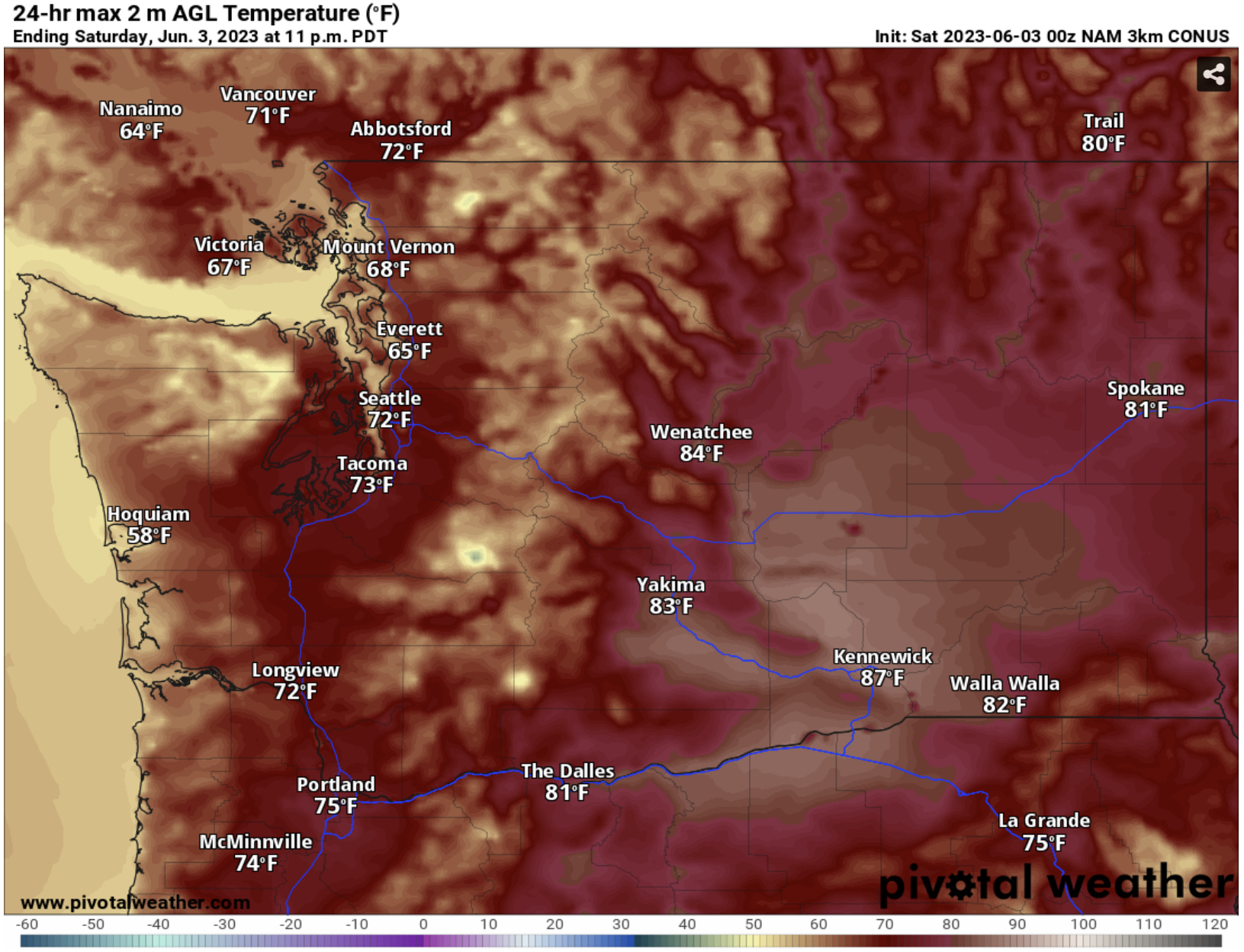
First, let’s take a look at Saturday’s highs from the GFS model, seen below.


Expect highs in the mid to upper 70s from Everett southward, and in the upper 60s to mid 70s from Everett northward. The coast will reach the upper 50s to mid 60s, and Eastern Washington will reach the upper 70s to mid 80s.

Let’s compare this to a higher-resolution forecast, the NAM model, which tends to run a couple degrees too cool.


The NAM shows highs in the low to mid 70s from Everett southward and in the mid 60s to low 70s from Everett northward. The coast will reach the upper 50s, and Eastern Washington will reach the low to mid 80s, except the upper 80s in the lower Columbia Basin.

Sunday’s forecast is a bit more complex. Temperatures will be lower than Saturday, due to stronger northerly winds in the lowlands. Let’s compare the forecasts, starting with the GFS.


Notice that the GFS shows temperatures in the lowlands dropping to the mid 60s to low 70s from Everett northward, and down to the low to mid 70s from Everett southward, except cooler near the water. The coast will still reach the mid 50s to mid 60s (warmest inland) and Eastern WA will reach the low to mid 80s, except the upper 80s in the Columbia Basin.

Now let’s compare this to the NAM forecast, which is likely completely overdoing the impacts of the Sound Breeze on the temperatures.


The NAM forecast drops highs on Sunday to the upper 50s to mid 60s in Western Washington, which is unrealistically low, since it would take quite a strong wind to drop temperatures that much. I’d expect Sunday’s highs to be in the upper 60s to low 70s across the lowlands, with some isolated areas very near Puget Sound remaining in the mid 60s.

How strong will the wind be? The European model’s forecast for peak winds on Sunday afternoon is below.


Expect gusts of 20-30 mph around the lowlands and 25-35 mph on the coast. Peak gusts will be in the afternoon, and it will likely make for a chilly day on the beach and around the Sound.

The NAM forecast is relatively similar for winds, which will peak on Sunday evening, seen below.


The NAM forecast agrees with winds west of the mountains, but increases winds out of gaps in the east slopes of the Cascades, especially the Kittitas Valley and areas SE of Wenatchee, where gusts will likely reach 40-50 mph.

Overall, expect a sunny and breezy weekend (and Monday), and stay tuned for updates on the potential hotter weather next week!

Tuesday, May 30, 2023

Gradual Warmup, Extended Warmth Expected

FastCast—Wednesday, May 31 to Sunday, June 4:

The past few days have been cooler than normal (by a couple degrees) due to a persistent marine layer that has moved in each morning, burning off in mid-afternoon. This has kept highs in the mid 60s to low 70s, near average for late May. Similar conditions will prevail on Wednesday, with mostly cloudy skies and highs in the low to mid 60s, potentially into the upper 60s if clouds burn off. Thursday will start off cloudy and become sunny, with highs reaching the upper 60s to low 70s. Additionally, Wednesday and Thursday morning’s lows will be on the chilly side, likely in the low to mid 40s. Conditions will become mostly sunny for Friday through Sunday, with highs in the mid to upper 70s, with some areas reaching the low 80s, mainly away from the water. From Thursday to Sunday, a stronger breeze off the water will bring cooler highs. Expect lows through Sunday to remain in the mid to upper 40s. There is a potential for warmer conditions into next week…so stay tuned!

————————————————————

Continue reading the full blog below!

Another day of morning to early afternoon clouds and potential afternoon sun is ahead on Wednesday. Below is the GFS forecast for highs.


Wednesday’s highs will reach the mid to upper 60s in the lowlands, with some areas north of Everett remaining in the low 60s. The coast will only reach the mid to upper 50s, and Eastern WA will reach the upper 60s to mid 70s. 

On Thursday morning, lows will be chilly. Let’s take a look at the GFS and European forecasts. First, the European (more likely) forecast for Thursday morning’s lows.


The European model shows lows in the lowlands dropping to the mid 40s, with some outlying locations dropping into the low 40s.

The GFS model shows a colder forecast, seen below.


This less likely forecast shows locations west of the Cascades dropping to the upper 30s to low 40s on Thursday morning, which is unlikely but still within the realm of possibilities.

Thursday’s highs will be warmer as clouds burn off and flow turns offshore, bringing an end to the morning clouds for awhile. Below is the GFS forecast for Thursday’s highs.


The GFS shows lowland highs in the mid to upper 60s north of Everett and in the upper 60s to mid 70s south of Everett. The coast will reach the upper 50s to low 60s, and Eastern WA will reach the low to mid 70s.

Friday’s highs will be warmer yet again, as seen in the GFS forecast below.


On Friday, expect highs in the mid 60s to low 70s from Everett north and in the mid to upper 70s from Everett south. The coast will again reach the upper 50s to low 60s, and Eastern WA will increase into the mid 70s to low 80s.

Now, let’s take a look at the extended outlooks from the NWS Climate Prediction Center. First, let’s look at the temperature outlook for June 5-9 (next week).


This outlook shows a 70-90% probability of above average temperatures across Washington to begin June, a strong signal for extended warm weather (and sun).

Next, the precipitation outlook for June 5-9, seen below.


This forecast shows a 33-40% probability of below average precipitation across Western WA, with average precipitation likely in Central WA, and a 33-40% probability of above average precipitation in SE WA. Also, note the 60-80% probability of above average precipitation over Northern CA, Nevada, Utah, and parts of Idaho, Wyoming, and Colorado. This is due to consistent showers and thunderstorms setting up over these areas.

Nice weather is ahead, and warm (and above average) temperatures are expected to continue through next week. Stay tuned!

Next Storm System Hits Western Washington

  8-26 Video Briefing: Next Storm System Hits Western Washington