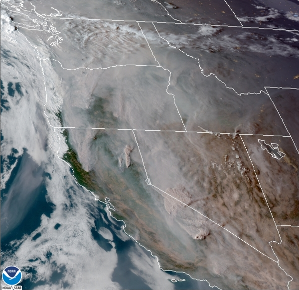
Wednesday was another day of "unhealthy" air quality and very smoky conditions. In the satellite image below, you can see how thick the smoke was over Washington, thicker than the past couple days due to winds bringing more Oregon smoke.
It sure isn't fun to see all that smoke. Here is Puyallup's 7 PM Wednesday AQI reading & forecast.
AQI is "unhealthy" and will likely remain that way through Thursday. Improvement begins Thursday night and Friday, with AQI likely returning to "good" by the weekend! This is great news!
Let's talk about rain...it is coming, and I’m as excited as you are!! There is also a chance of thunderstorms Thursday night and Friday morning, going along with the rain.
Below is the UW WRF model, showing rain from 5 AM Thursday to 5 AM Saturday.
The forecast shows that our area gets 0.32-1.28 inches of rain! Expect most of the rain to be late Thursday into Friday. This will help to improve the air quality and squelch the smoke. Remember, rain will help clear the smoke, but marine air on Saturday and Sunday will be the real difference-maker.
Back to rain...here is the 7-day rain forecast.
This runs from Wednesday (16th) to next Wednesday (23rd). It shows a major 5-10 inch soaking of Vancouver Island, up to 5 inches on the WA coast, and up to 1.2 inches here in the lowlands. I’d expect this to fluctuate some, but it is likely that we will have over a half inch of rain through the next week.
Earlier, I mentioned the chance of thunderstorms Thursday night-Friday morning. The NWS Storm Prediction Center (SPC) has a risk of thunderstorms over all of our area, with a marginal risk of severe storms over parts of Oregon.
Here’s 8 PM Thursday.
CAPE values of 200-600 over Puget Sound, with 1000+ over the coast, Cascades, and SW Washington/NW Oregon. This definitely supports thunderstorms. Expect storms to move north, typical for thunderstorm events in Western Washington.
Here’s 5 AM Friday.
Still 100-400 CAPE around the area. Some forecasts are favoring thunderstorms in Puget Sound on Friday during the day, from 9 AM-5 PM. Don’t rule this out. The UW satellite simulation, below, shows a thunderstorm (circled in red) over Puget Sound at 3 PM Friday.
Instability is likely from Thursday night through Friday night, so don’t be surprised to hear a rumble of thunder or see some lightning. Remember to take safety precautions during thunderstorms.
Here’s a graphic from NWS Seattle showing some smoke safety and weather information.
Here’s the bottom line: Expect smoke to last through Thursday with some improvement, with major improvement by the weekend. Rain is likely and thunderstorms are possible from Thursday night through the day Friday.


No comments:
Post a Comment