Monday, July 29, 2024

Rain Returns to Western Washington

 FastCast--Monday, July 29 to Thursday, Aug. 1:

After weeks of mostly dry conditions, rain is returning to Western Washington on Monday. However, it won't be enough to put out any wildfires across the region. Expect rain at times from early Monday morning through the evening, turning showery from Monday night through Tuesday. In the lowlands, amounts of 0.15-0.5" are expected, most from Seattle northward due to rain-shadowing from the Olympic Mountains. Areas from Everett northward and on the coast will receive 0.4-0.8". The western slopes of the Cascades will likely receive 0.5-1.5" of rain, most from Snohomish County northward. This rain will decrease sharply from the crest of the Cascades and eastward, with forecasts predicting under 0.15" for major wildfires in Eastern Washington. Temperatures will be noticeably cooler across the region on Monday, with highs only reaching the mid to upper 60s. Tuesday will see a warmup to the upper 60s to low 70s, followed by decreasing clouds and highs in the mid 70s to low 80s on Wednesday. Mostly sunny conditions are expected on Thursday as well, with highs increasing to the upper 70s to mid 80s. A very warm Seafair weekend is possible, so stay tuned.

Click here for my video from the Retreat Fire (near Naches, WA) on July 27, 2024 (includes interview with fire Public Information Officer).

----------------------------------------------------------------

Continue reading the full blog below!

Rain is returning to Western Washington! Ironically, this will be happening on the driest day of the year (statistically), with rain on July 29th only 4 times since 1945. The record of 0.17" in Seattle will likely be broken, although forecasts vary on the actual rain amounts. Let's take a look at the forecast!

We'll start with the forecast from the NWS NBM high-resolution model, seen below.


This forecast shows a rain shadow SW of the Olympics, including most areas from Everett southward. This rain shadowed region will get 0.1-0.3" of rain, while areas from Everett northward and on the coast receive 0.4-0.8". The west slopes of the Cascades will receive 0.5-1.5". However, wildfires on the east slopes of the Cascades (Pioneer & Retreat Fires) will only receive 0-0.15" in this forecast. 

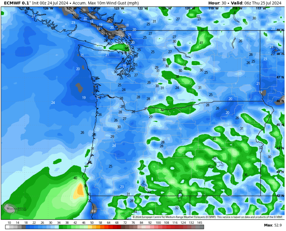
Next, let's compare this to the more ambitious European model forecast, seen below.


This forecast shows much less rain shadow impacts, with the lowlands getting 0.3-0.5", areas from Everett to Mount Vernon getting 0.5-0.9" due to Convergence Zone activity on Tuesday, and the coast getting 0.5-1.1". The western slopes of the Cascades get 0.5-1.8", and the Pioneer & Retreat Fires get 0.05-0.15".

While this rain will be short-lived, with showers coming to an end by Tuesday, it will provide necessary temperature, cloud cover, and humidity-related relief for wildfires across the state. 

Temperatures will be noticeably cooler on Monday than on any previous day as of late. Below is the NWS NBM forecast for Monday's highs.


On Monday, lowland highs will only reach the mid 60s, while the coast reaches the low to mid 60s. The Willamette Valley will reach the low to mid 70s, and Eastern Washington will cool to the upper 70s to mid 80s.

Tuesday will be a bit warmer across the state, seen below.


On Tuesday, expect lowland highs in the upper 60s to low 70s, with coastal highs in the mid to upper 60s, and Willamette Valley highs in the upper 70s to low 80s. Eastern Washington will warm to the mid to upper 80s, although some areas will remain in the upper 70s to low 80s.

By Wednesday, noticeable warming is observed across Washington.


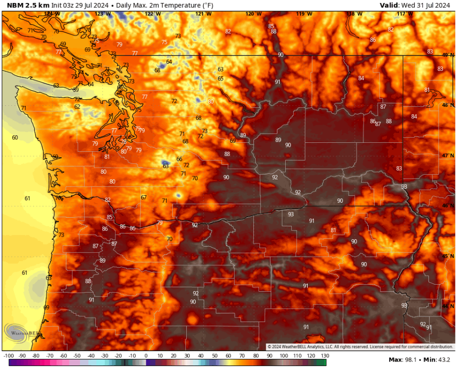
On Wednesday, expect lowland highs in the mid 70s to low 80s, with coastal highs in the mid 60s to low 70s, and Willamette Valley highs reaching the mid 80s to low 90s. Eastern Washington will warm to the upper 80s to low 90s.

Let's take a look at the European Ensemble's extended forecast for Seattle, showing possible temperatures over the next 2 weeks.


Notice a significant warmup after the rain moves through, with potential for quite a warm Seafair weekend, with highs in the mid to upper 80s (or warmer) possible.

Stay tuned, as there's a lot to nail down in the forecast over the next few days!

Tuesday, July 23, 2024

Major Fire Weather Concerns Across the Northwest

 FastCast--Wednesday, July 24 to Sunday, July 28:

After weeks of hot temperatures, and a record-setting 17 straight 80°+ days in Seattle, Western Washington is back to near-normal temperatures. This comes at the expense of Eastern Washington, since cooler conditions to the west bring gusty winds and low humidity to the east. In the lowlands, expect areas of morning marine clouds each morning through Sunday. Highs will generally reach the mid 70s to low 80s, hottest on Friday and Saturday. Isolated locations near the water will remain in the low to mid 70s, while some areas inland and in valleys could reach the mid 80s. Low temperatures will be refreshing, generally in the low to mid 50s, except in the upper 50s in dense urban areas. Some outlying regions could drop to the upper 40s! Continue reading below for an update on the significant fire weather concerns across the Northwest over the next couple days.

--------------------------------------------------------------------

Continue reading the full blog below!

Although temperatures have mostly returned to normal across the Northwest, the most hazardous weather conditions of the year have been impacting the region over the past few days, and the next couple days won't be any different.

A large-scale dry thunderstorm event is expected to take place on Wednesday across Eastern Oregon and parts of Idaho. Massive amounts of lightning, combined with strong thunderstorm outflow winds, will lead to very dangerous fire conditions. Below is the NWS Storm Prediction Center (SPC) outlook for fire weather conditions on Wednesday.


The red shaded areas have a high risk of dry thunderstorms, while a somewhat lesser risk exists across the brown shaded areas. In addition to dry thunderstorms, some thunderstorms across Idaho and Eastern Oregon will be strong enough to warrant a risk of severe thunderstorms. This means even more lightning is possible. Areas in orange have a wind-related risk of dangerous fire weather. This includes the Washington Cascades and parts of Eastern Washington.

Let's take a look at the lightning potential for Wednesday afternoon, from the European model.


That is a massive amount of potential lightning across Eastern Oregon, parts of Idaho, and parts of California and Nevada. The most concerning part of this is that there are already hundreds of smaller fires and a few massive fires in the lightning area. New starts are almost a certainty, meaning that resources may have to be pulled from existing fires. Additionally, thunderstorms make it much harder for aircraft to fight fires.

For folks in Washington thinking that this thunderstorm outbreak won't impact us, remember that smoke from new and existing fires in Oregon has a decent chance of impacting Washington in the coming weeks and months. This is also the reason why it's important to monitor fires in British Columbia, where a massive lightning barrage sparked 100+ new fires on Sunday.

The other component of the fire weather setup is wind. Below is the European model forecast for peak winds on Wednesday.


Notice erratic thunderstorm outflow winds across Eastern Oregon and parts of Idaho. These gusts, possibly 40-50 mph, will create extreme and erratic fire behavior, in addition to abundant dry lightning. Across Eastern Washington and Northern Oregon, gap winds along the east slopes of the Cascades will gust 35-45 mph, allowing existing fires to grow rapidly and promoting very fast fire spread on any new starts.

This is overall a very dangerous situation for the region, especially Oregon, which has been incredibly hard-hit by fires so far. If you are interested in tracking wildfires, I suggest downloading the Watch Duty app or checking out their wildfire map (click here). Scroll the map to the PNW to see current fires. Below is a screenshot of what the map looks like as of Tuesday night. Safe to say that it is already a very active fire season across the Northwest.

Regarding wildfire smoke, windy conditions around fires means that smoke will largely be concentrated in plumes downwind of fires. A new fire on Vancouver Island, near Sooke, may bring degraded air quality to San Juan and Whatcom Counties, while areas downwind from fires in Eastern Washington will experience degraded AQI. 

Now, let's talk temperatures. After weeks of heat, Washington will largely have seasonable temperatures over the next few days. Below is the NWS NBM forecast for highs on Wednesday.


On Wednesday, lowland highs will reach the mid to upper 70s, while the coast reaches the mid to upper 60s, and the Willamette Valley reaches the low to mid 80s. Eastern Washington will reach the low 90s to low 100s, hottest in valleys and around the Tri-Cities.

Thursday's forecast is below, also from the NWS NBM model.


Notice that Thursday is significantly cooler across Eastern Washington, partially due to the strong winds on Wednesday evening. The lowlands will cool to the low to mid 70s, while the coast remains in the mid 60s, and the Willamette Valley drops to the upper 70s to low 80s. Eastern Washington will be the coolest it's been in weeks, with highs in the upper 70s to mid 80s.

Next, the NWS NBM forecast for Friday.


Friday will be a bit warmer across the region. The lowlands will reach the mid 70s to low 80s, the coast will reach the mid to upper 60s, and the Willamette Valley will reach the mid 80s. Eastern Washington will warm to the mid to upper 80s.

Finally, here's the NWS NBM forecast for Saturday.


On Saturday, the lowlands, coast, and Willamette Valley will be very similar to Friday's temperatures above. Eastern Washington will warm further, likely reaching the upper 80s to low 90s.

One final note...I will be traveling through Saturday, so I will not have any blogs until Sunday. To stay updated on current conditions, I recommend watching local meteorologist Michael Snyder's Pacific Northwest Weather Watch YouTube channel. A daily briefing is uploaded each morning! 

Stay safe, be careful, and do everything you can to prevent wildfires!

Sunday, July 21, 2024

Update on Potential Thunderstorms, Fire Weather Conditions, and Smoke

No FastCast today...continue reading below for an update on the current weather situation. This is also my 700th blog post...so thank you very much to all who read the blog, and especially to those who have followed from the beginning!

---------------------------------------------------

Update 12:30 AM Sunday: 

The NWS Storm Prediction Center has upgraded the Puget Sound lowlands to a threat of isolated dry thunderstorms, with the risk area stretching along the I-5 corridor from Skagit County southward, and in the Cascades from Whatcom County southward, and also including plenty of Eastern WA. The red shaded area over SE Oregon and the Great Basin is an even higher risk for more organized dry thunderstorms.


This risk is rare for Western Washington, but the threat is even higher for the Inland NW. The Storm Prediction Center warns of an "outbreak" of dry lightning across the "Interior Northwest", which will bring a very high likelihood of more fires. The full blog is below.

------------------------------------------------------------------------------

An interesting situation is ahead, as another plume of monsoon moisture moves northward into the Pacific Northwest. Let's take a look at the forecast...there's a lot going on!

We'll start with the potential chance of thunderstorms on Sunday. This is using the HRRR high-resolution forecast for lightning flash density. We start at 10 AM Sunday.


At 10 AM, the HRRR shows thunderstorms moving northward along the WA coast and up the I-5 corridor.

By 12 PM, these storms are moving closer.


At noon, storms are impacting areas from the Olympic Mountains all the way to the Columbia River Gorge, moving toward the metro area and continuing to impact the I-5 corridor from Olympia to Portland.

Next, here's 2 PM.


By early afternoon, storms are moving through the San Juans, SW BC, the Kitsap Peninsula, and are near the metro area. After this, storms will continue moving north and slightly east, weakening as they do so. 

The graphic below is outdated. See the graphic in the update above for the latest information.

Thunderstorms are even more likely over the Eastern Oregon, the Oregon Cascades, and parts of the Washington Cascades. Due to this, there are significant dry lightning concerns, as little to no precipitation is expected with any thunderstorm. Below is the NWS Storm Prediction Center (SPC) outlook for Sunday.


This outlook shows a dry thunderstorm threat for the Central and Southern WA Cascades, the I-5 corridor from Lewis County to Eugene, and most of the Oregon Cascades. The red shaded area over SE Oregon has an even higher potential for dry thunderstorms, which is concerning due to the fact that multiple major fires are already active in these areas.

Fire weather conditions will not be helped by temperatures on Sunday, as seen below in the NWS NBM forecast for highs.


On Sunday, the lowlands will reach the mid 70s to mid 80s, hottest from Seattle south and in the valleys. The Willamette Valley will reach the low to mid 80s, and the coast will cool to the mid to upper 60s (low 60s at the beaches). However, Eastern Washington will be dangerously hot, with highs in the mid 100s to low 110s. Some locations (in valleys and the lower Columbia Basin) have a chance of reaching the mid 110s, extremely dangerous levels if you are outside.

Due to the combination of dry thunderstorms, extreme heat, and expected winds gusting 25-40 mph across the region, a vast area of Eastern WA & OR is under Red Flag Warnings, as seen below.


Nearly the entirety of Oregon, except for parts of the northern tier, is under a Red Flag Warning, while in Washington, the entirety of the Cascades, the Olympics, and most of Chelan & Okanogan Counties are all under Red Flag Warnings.

Monday doesn't bring much (if any) relief for fire weather conditions. Temperatures are expected to drop (described in the previous blog post), but wind will increase due to the influx of somewhat cooler air. Below is the European model forecast for peak wind by Monday night.


This is concerning. Areas of Eastern Oregon, the OR & WA Cascades, the Columbia Gorge, and the Kittitas Valley are all expected to gust 30-45 mph, with isolated gusts of 45-50 mph for the Kittitas Valley and Columbia River Gorge. These winds are very problematic for fire spread, especially since they will be accompanied by relative humidity of 10-40%.

Finally, let's take a look at the forecast for smoke aloft on Sunday. Note: Expect degraded air quality due to surface smoke across Eastern Washington at times on Sunday, especially in the morning.

Below is the HRRR forecast for smoke aloft around sunrise.


Notice light to moderate concentrations across Western WA, with heavy concentrations over Oregon.

By midday, concentrations are heavier across the region.


By around midday, moderate to heavy smoke aloft is moving over nearly all of Washington, except the NE section.

By sunset, the impacts of another windy day are apparent.


You can tell that by Sunday night, many smoke plumes have been active across the region. Heavy smoke concentrations are present over Eastern Oregon and Washington, with light to moderate concentrations of smoke aloft west of the Cascades. 

In short...a lot is happening over the next couple days. Stay tuned for more updates, do your part to prevent fires, and keep an eye to the sky!

Friday, July 19, 2024

Heat Relief to Bring Smoke & Storms to Washington

 FastCast--Saturday, July 20 to Tuesday, July 23:

Seattle has officially reached an all-time record of 16 consecutive 80°+ days, with 1-2 more days expected to crest 80°. Saturday will be hot, with highs from Everett north in the upper 70s to mid 80s, and areas from Everett south in the mid 80s to low 90s. Relief begins on Sunday, with some forecasts showing a chance of showers and thunderstorms, with generally cloudier conditions expected. Highs will reach the upper 70s to mid 80s, hottest in valleys and away from the water. Additionally, breezy conditions (20-30 mph) are possible across the area on Sunday evening, with winds near the Strait of Juan de Fuca likely gusting 35-45 mph, quite strong for summer. Partly cloudy conditions are ahead on Monday and Tuesday, with highs in the mid to upper 70s across the region. In the metro area, expect lows in the upper 50s to low 60s through Monday morning. Refreshing lows in the low to mid 50s, except in the mid to upper 50s in the metro area, are expected from Tuesday onward. Additionally, from early Sunday onward, wildfire smoke aloft will likely bring hazy skies to the region, and although no impact to air quality is expected, temperatures may not exactly reflect the forecast due to smoke.

---------------------------------------------------------------

Continue reading the full blog below!

As heat relief slowly moves through Washington, it will bring smoke into the region, and a chance of showers and thunderstorms on Sunday (this is somewhat uncertain). But first, more heat is ahead, especially for Eastern Washington. So, let's take a look at the forecast.

First, the NWS NBM forecast for highs on Saturday.


On Saturday, expect highs from Everett north to reach the upper 70s near water to the mid 80s inland. Areas from Everett south will reach the mid 80s to low 90s, hottest away from the water. The Willamette Valley will reach the mid 90s (isolated upper 90s possible). Eastern Washington will reach the low to mid 100s. The coast will reach the low to mid 70s, except the mid to upper 60s at the beaches.

Relief will begin slowly for areas west of the Cascades on Sunday, while Eastern Washington records one of its hottest days yet. Below is the forecast from the NWS NBM model.


On Sunday, Western Washington will reach the upper 70s to mid 80s, hottest from Seattle south and in valleys, while the Willamette Valley will reach the low to mid 80s. The coast will cool to the low 60s at the beaches and mid to upper 60s inland. Eastern Washington will be sweltering, with highs in the mid 100s to low 110s, with potential for some parts of the Columbia Basin and mountain valleys to reach the mid 110s. These are extremely dangerous temperatures. Please take precautions from the heat if you will be in these areas.

Sunday will be an interesting day, with the HRRR high-resolution forecast and other high-res models showing a potential for brief showers (a trace to no rainfall) and possible thunderstorms moving through the area. Below is the latest HRRR forecast for potential lightning late on Sunday afternoon.


Prior to this, the HRRR forecast shows thunderstorms moving through the Willamette Valley, parts of the Cascades, the I-5 corridor in WA, and the Washington & Oregon coasts. The current forecast ends before potential thunderstorms exit the region. It is important to note that this is quite uncertain, and due to that, I will post another update by late Saturday night, so stay tuned.

Since heat relief is coming to areas west of the Cascades on Sunday, that means onshore flow is expected as well. Onshore flow typically brings winds from the south/southwest, and due to the large amount of new fires in Oregon, this means that wildfire smoke will move into the region. Thankfully, it will be aloft and will NOT have an impact on air quality west of the Cascades. Below is the HRRR forecast for smoke aloft around midday Sunday.


This forecast shows a decent amount of smoke aloft over the region. This will not have any impacts except for possibly lowering temperatures a bit from Sunday's forecast. This smoke may be less noticeable due to the potential showers and thunderstorms moving through the region, but anytime there is sun, it will likely be tinted red. 

Due to the vast amount of fires (new and existing) across Washington, Oregon, and British Columbia, we will likely be dealing with smoke (either aloft or at the surface) for the foreseeable future across the Pacific Northwest.

Finally, Sunday will also bring gusty winds as cooler air surges into Western Washington. These gusty winds will accelerate through gaps in the Cascades and the Strait of Juan de Fuca. The European model forecast is below.


This forecast shows breezy areas in Western Washington, with winds along the Strait gusting 35-45 mph. Additionally, the Kittitas Valley, Columbia River Gorge, and some parts of the Cascades will gust 30-40 mph. This will not be helpful to fires, and will likely create smoke plumes that will push east across Eastern WA & OR.

With more heat relief region-wide on Monday, an even stronger round of winds is expected, which will likely bring dangerous fire conditions and more smoke to Eastern Washington and the Cascades. Stay tuned for more information regarding this. I will have an update by late Saturday night.

Wednesday, July 17, 2024

Update: Thunderstorms and High Fire Danger Imminent Across the Northwest

No FastCast tonight...continue reading tonight's update about the incoming thunderstorms and high fire danger.

Thunderstorms have already impacted Southern Oregon, from the coast near Coos Bay to the Cascades near Crater Lake and points eastward. There have already been many new small fires started as a result of these storms. This activity, due to a plume of monsoon moisture, is moving north into Northern Oregon and Washington.

The timing of storms is as follows...overnight into the early morning hours for Northern Oregon (on both sides of the Cascades) and parts of Southern Washington (also on both sides of the Cascades). The threat of thunderstorms continues into the morning with a slight chance of thunderstorms from 5-10 AM across the Puget Sound region (mainly south of Seattle), and a greater chance over southern parts of Eastern Washington and parts of the Cascades. 

The threat ramps up for the Washington Cascades, the Olympics, and parts of Eastern Washington from late morning through 8-10 PM. There is a good chance of thunderstorms with a large amount of dry lightning during this time across the Cascades. Some forecasts are also calling for another round of storms near the lowlands during this time, so be prepared.

We'll start with the forecast for instability (CAPE index) on Wednesday afternoon, from the high-resolution HRRR forecast.


This forecast shows high CAPE values of 300-4000 across the region, most elevated in the Cascades. This shows that there is a good chance of thunderstorm development.

Concerningly, though, is the lack of rainfall with these storms. This is due to the fact that the storms are high-based, with little to no rainfall reaching the surface. Below is the European model forecast for total rain through Thursday.


This forecast doesn't paint a good picture. With very isolated pockets of rainfall over 0.2" with these storms, and most having 0-0.1" total, there is a high potential for dry lightning, where frequent lightning strikes are not accompanied by rainfall that could extinguish any fires.

Due to this, the NWS Storm Prediction Center (SPC) has put most of Washington and part of Oregon under a risk area for dry thunderstorms on Wednesday.


This risk area encompasses all of Washington from the Cascade foothills eastward into the Idaho Panhandle, and southward into parts of Oregon, from Portland eastward to the Idaho border, and southward toward Bend.

In that risk area is the highest chance for thunderstorms, especially over the Cascades. Below is the European model forecast for potential lightning probability on Wednesday afternoon.


Wow...the Cascades are a lightning bullseye, with a high probability for storms with large amounts of lightning on Wednesday afternoon. This does not bode well for new fire starts (and for growth of existing WA & OR fires due to gusty outflow winds from thunderstorms).

However, the high-resolution models believe that storms may not be limited to the Cascades, even in the afternoon. Below is the HRRR forecast for potential lightning on Wednesday, around 3-5 PM.


This forecast shows storms over the Cascades, with potential storms moving northward through the lowlands. This is a lesser probability event, but still possible. It will be important to have an eye to the sky and to take caution across the region on Wednesday. Even if no rain is falling, lightning is still possible.

Finally, let's talk Wednesday's temperatures. Below is the NWS NBM high-resolution temperature forecast.


This forecast shows lowland highs in the low to mid 80s, with isolated areas reaching the upper 80s. Meanwhile, the Willamette Valley reaches the upper 80s to low 90s, Eastern Washington reaches the upper 90s to mid 100s, and the coast remains in the mid 60s to low 70s.

It is important to note that temperatures across the region could be warmer or colder due to cloud cover. If clouds are thicker, take 3-5+ degrees off these highs, but if clouds move out earlier, temperatures could be warmer than expected.

The bottom line is that due to the threat of dry lightning and numerous thunderstorms, there is high fire danger and a very high risk of new fire starts on Wednesday. Please take caution and keep an eye to the sky!

Monday, July 15, 2024

Potential Thunderstorms Bringing High Fire Danger

FastCast--Tuesday, July 16 to Thursday, July 18:

An interesting period is ahead for the region, with a shortwave trough bringing a regionwide chance of thunderstorms on Wednesday, which will bring high fire danger, especially because the thunderstorms will have little to no rain in them. But first, the heat will return on Tuesday, with highs across the lowlands reaching the mid 80s to low 90s, except cooler near the water, especially north of Everett. There is a chance of thunderstorms across the lowlands, mainly Wednesday morning, but this is more fickle and unpredictable than the potential thunderstorms over the Cascades. On Wednesday, clouds are expected to start the day west of the Cascades, with skies getting sunnier, and highs reaching the low to mid 80s (upper 80s possible for some areas). Thursday will likely begin with morning clouds, with highs cooling a bit into the low to mid 80s (upper 70s to low 80s from Everett northward, mainly near the water). Overnight lows will only drop to the low to mid 60s on Wednesday and Thursday mornings, but will likely drop back to the upper 50s after that. Continue reading below for an update on the active weather ahead.

------------------------------------------------------------------

Continue reading the full blog below!

A weather system, known as a "shortwave trough" will move through the Pacific Northwest from Tuesday through Wednesday, bringing a chance of widespread thunderstorms to the region, especially the Cascades. This brings a high risk of many new fire starts, especially due to the risk of dry lightning. Let's take a look at the forecast!

Below is the forecast showing forecasted instability (CAPE index) across the region on Wednesday evening, from the HRRR high-resolution forecast.


This forecast shows high CAPE across the region, with values of 500-2500 (high by PNW standards) in the Cascades and Olympics.

Let's take a look at how this event will play out. We'll start with the European model forecast for lightning flash density (amount of potential lightning in an area), for Tuesday afternoon.


On Tuesday afternoon, thunderstorms are expected over the Cascades and highlands of Southern Oregon. This is concerning as there are already large wildfires in this area. Additionally, there is a lesser chance of thunderstorms on Tuesday afternoon for the Cascades and Olympics.

As we go into Tuesday night and early Wednesday morning, thunderstorms will move northward. Below is the European model forecast for where thunderstorms could be early Wednesday morning.


Before sunrise on Wednesday, thunderstorms will be moving north, with a potential area of thunderstorms moving north up the Washington and Oregon coasts, and additional thunderstorms moving north through the Oregon Cascades. There is potential for thunderstorms to impact the Willamette Valley early Thursday morning.

Next, let's look at thunderstorm potential for Wednesday morning (from approximately sunrise to midday).


As we move through Wednesday morning, thunderstorms will continue to impact the northern Oregon Cascades, likely spilling into the southern Washington Cascades. Additional storms are possible along the coast and in NW Oregon, including the Willamette Valley. 

The situation will change immensely on Wednesday afternoon, as seen below.


From early to mid afternoon on Wednesday, thunderstorms will become quite active over the southern Washington Cascades and over parts of northern Oregon, mainly east of the Cascades. There is also a lesser chance of thunderstorms over the Olympics.

Then, by the middle to later part of Wednesday afternoon, into Wednesday evening, is the highest chance of thunderstorms, likely across the majority of the Washington Cascades.


By this time, there is a potential for high amounts of lightning across the entirety of the Washington Cascades, the Olympics, and parts of the Blue Mountains from north central Oregon into extreme SE Washington. 

Going into Wednesday night, thunderstorm activity will likely decrease and move east. The biggest threat with this thunderstorm activity is the lack of precipitation with these storms. Below is the European model forecast for total rain through Wednesday night.

Notice that the maximum amount of precipitation in the Cascades is around 0.15", with similar maximum amounts along the coast, the Olympics, the Oregon Cascades, and the Blue Mountains.

This combination of the potential for a large amount of lightning strikes and little to no precipitation will create a very dangerous environment for new wildfires. Below is the National 7-Day Significant Fire Outlook from the NWCG (National Wildfire Coordinating Group), valid for Wednesday.


Any areas in red have a high risk of fire potential, with orange/tan areas being a moderate risk of fire potential. "L" represents lightning, and "B" means "critical burn environment." It's safe to say that there is a high risk of new wildfires and growth of existing fires.

Finally, let's take a look at expected temperatures on Tuesday and Wednesday. It's going to heat up across the region over the next few days. The NWS NBM forecast for highs on Tuesday is below.


On Tuesday, lowland highs will reach the upper 70s to mid 80s from Seattle north and the upper 80s to low 90s from Seattle south. The coast will reach the upper 60s near the beaches to the upper 70s inland. The Willamette Valley will reach the mid to upper 90s, and Eastern Washington will reach the upper 90s to low 100s (isolated mid 100s possible).

Wednesday's temperatures will be a bit different due to the thunderstorms and associated clouds moving through the region at times. In Western Washington, this will also bring muggier conditions.


On Wednesday, highs across the lowlands will reach the mid to upper 80s, with areas near the water in the upper 70s to low 80s. The coast will reach the mid 60s to low 70s, while the Willamette Valley will reach the upper 80s to low 90s. Eastern Washington will reach the upper 90s to low 100s, with some areas reaching the mid 100s. Again, temperatures west of the Cascades and in the mountains themselves are highly dependent on how much cloud cover there is across the region. Thick clouds associated with the moisture moving through will lower temperatures a few degrees.

Stay tuned for an update by Tuesday night regarding the forecast for thunderstorms, fire danger, and temperatures.

Friday, July 12, 2024

Heat Continues Across the Pacific Northwest

 FastCast--Saturday, July 13 to Wednesday, July 17:

The slight cooling over the past couple days is likely to be short-lived across the Northwest, as a high pressure ridge briefly rebuilds and brings more hot conditions to the region. This weekend will be on the hotter side, especially on Saturday. For Saturday's highs, areas north of Seattle will reach the upper 70s to mid 80s, while areas south of Seattle will reach the upper 80s to low 90s. Sunday will be a bit cooler, with some areas of morning clouds, and highs from Seattle north in the mid 70s to low 80s, and in the mid to upper 80s from Seattle south. More morning clouds and cooling is ahead on Monday, with highs in the mid 70s to mid 80s, warmest from Seattle southward. However, the "relief" will likely be short-lived. On Tuesday, temperatures increase to the upper 70s to mid 80s north of Seattle and the mid 80s to low 90s from Seattle south. Wednesday looks to be hotter, with highs from Seattle north in the low to mid 80s, and highs from Seattle south in the upper 80s to low 90s. One thing to note is that high clouds will likely be moving through the area on Tuesday and Wednesday, which could keep temperatures down a few degrees from the forecast. Low temperatures across Western Washington will be in the upper 50s to low 60s, except in the low to mid 50s on the coast. Stay tuned for more information about the impacts of this prolonged "heat wave" across the region.

-------------------------------------------------------------

Continue reading the full blog below!

After a few somewhat "cooler" days across the Northwest, the heat is back. Warmer conditions are expected on Saturday, and to a lesser extent, on Sunday. The region is likely to remain mostly dry for the foreseeable future, giving no help to containing wildfires. Let's take a look at the forecast!

We'll start with highs on Saturday, seen below on the NWS NBM high-resolution model.

This forecast shows Saturday's highs in the upper 70s to mid 80s from Seattle northward, and in the mid 80s to low 90s from Seattle south. The Willamette Valley will reach the low to mid 90s, and Eastern Washington will reach the upper 90s to mid 100s, hottest around the Tri-Cities. The coast, meanwhile, will reach the mid 60s at the beaches to low 70s inland.

Moving to Sunday, some cooling is likely for Western Washington, as seen below.


On Sunday, expect highs from Seattle north to reach the mid 70s to mid 80s, while areas from Seattle south will reach the mid to upper 80s. The coast will cool to the mid 60s to low 70s, with some beaches remaining in the low 60s. The Willamette Valley will reach the upper 80s to low 90s, and Eastern WA will reach the mid 90s to low 100s.

Monday will bring more cooling, and will be the "coolest" day for at least 5 days.


On Monday, temperatures in the lowlands will reach the mid 70s to low 80s from Seattle north and the low to mid 80s from Seattle south. The coast will reach the mid to upper 60s (low to mid 60s at the beaches), and the Willamette Valley will reach the upper 80s to low 90s. Eastern Washington will drop slightly to the low 90s to low 100s.

Tuesday brings the start of another warmer period, although temperatures could be a few degrees below what is shown due to some high clouds moving through the region (stay tuned to see if this pans out). Below is the NWS NBM forecast for Tuesday.


On Tuesday, highs from Seattle north will reach the upper 70s to mid 80s, while highs from Seattle south will reach the mid 80s to low 90s. The Willamette Valley will reach the low to mid 90s, and Eastern Washington will reach the upper 90s to low 100s. The coast will warm up a bit, with highs increasing to the low to mid 70s, except still in the mid to upper 60s at the beaches.

Further warmth is possible on Wednesday, with above average conditions likely to continue through the next 7-10 days. This is due to persistent high pressure ridging over the Western US and Western Canada. This ridging deflects incoming Pacific systems, allowing the West to remain hot and dry. 

The 10-day precipitation forecast from the European model paints a concerning picture.


This forecast shows a potential for some light rain (under 0.05") next week along the coast, and concerningly shows very light rain, produced by thunderstorms, over the Cascades. Any threat of mostly dry thunderstorms at this time of year is very concerning. Stay tuned for more information as this hot and dry stretch continues across the Northwest.

Next Storm System Hits Western Washington

  8-26 Video Briefing: Next Storm System Hits Western Washington