FastCast--Saturday, July 20 to Tuesday, July 23:
Seattle has officially reached an all-time record of 16 consecutive 80°+ days, with 1-2 more days expected to crest 80°. Saturday will be hot, with highs from Everett north in the upper 70s to mid 80s, and areas from Everett south in the mid 80s to low 90s. Relief begins on Sunday, with some forecasts showing a chance of showers and thunderstorms, with generally cloudier conditions expected. Highs will reach the upper 70s to mid 80s, hottest in valleys and away from the water. Additionally, breezy conditions (20-30 mph) are possible across the area on Sunday evening, with winds near the Strait of Juan de Fuca likely gusting 35-45 mph, quite strong for summer. Partly cloudy conditions are ahead on Monday and Tuesday, with highs in the mid to upper 70s across the region. In the metro area, expect lows in the upper 50s to low 60s through Monday morning. Refreshing lows in the low to mid 50s, except in the mid to upper 50s in the metro area, are expected from Tuesday onward. Additionally, from early Sunday onward, wildfire smoke aloft will likely bring hazy skies to the region, and although no impact to air quality is expected, temperatures may not exactly reflect the forecast due to smoke.
---------------------------------------------------------------
Continue reading the full blog below!
As heat relief slowly moves through Washington, it will bring smoke into the region, and a chance of showers and thunderstorms on Sunday (this is somewhat uncertain). But first, more heat is ahead, especially for Eastern Washington. So, let's take a look at the forecast.
First, the NWS NBM forecast for highs on Saturday.

On Saturday, expect highs from Everett north to reach the upper 70s near water to the mid 80s inland. Areas from Everett south will reach the mid 80s to low 90s, hottest away from the water. The Willamette Valley will reach the mid 90s (isolated upper 90s possible). Eastern Washington will reach the low to mid 100s. The coast will reach the low to mid 70s, except the mid to upper 60s at the beaches.
Relief will begin slowly for areas west of the Cascades on Sunday, while Eastern Washington records one of its hottest days yet. Below is the forecast from the NWS NBM model.
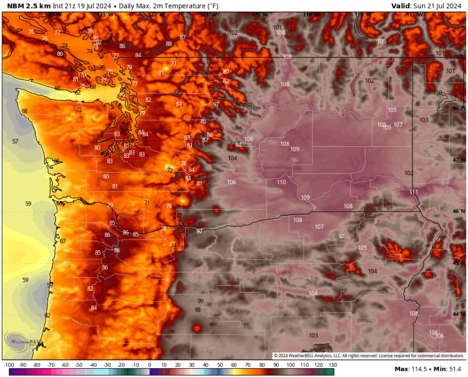
On Sunday, Western Washington will reach the upper 70s to mid 80s, hottest from Seattle south and in valleys, while the Willamette Valley will reach the low to mid 80s. The coast will cool to the low 60s at the beaches and mid to upper 60s inland. Eastern Washington will be sweltering, with highs in the mid 100s to low 110s, with potential for some parts of the Columbia Basin and mountain valleys to reach the mid 110s. These are extremely dangerous temperatures. Please take precautions from the heat if you will be in these areas.
Sunday will be an interesting day, with the HRRR high-resolution forecast and other high-res models showing a potential for brief showers (a trace to no rainfall) and possible thunderstorms moving through the area. Below is the latest HRRR forecast for potential lightning late on Sunday afternoon.

Prior to this, the HRRR forecast shows thunderstorms moving through the Willamette Valley, parts of the Cascades, the I-5 corridor in WA, and the Washington & Oregon coasts. The current forecast ends before potential thunderstorms exit the region. It is important to note that this is quite uncertain, and due to that, I will post another update by late Saturday night, so stay tuned.
Since heat relief is coming to areas west of the Cascades on Sunday, that means onshore flow is expected as well. Onshore flow typically brings winds from the south/southwest, and due to the large amount of new fires in Oregon, this means that wildfire smoke will move into the region. Thankfully, it will be aloft and will NOT have an impact on air quality west of the Cascades. Below is the HRRR forecast for smoke aloft around midday Sunday.

This forecast shows a decent amount of smoke aloft over the region. This will not have any impacts except for possibly lowering temperatures a bit from Sunday's forecast. This smoke may be less noticeable due to the potential showers and thunderstorms moving through the region, but anytime there is sun, it will likely be tinted red.
Due to the vast amount of fires (new and existing) across Washington, Oregon, and British Columbia, we will likely be dealing with smoke (either aloft or at the surface) for the foreseeable future across the Pacific Northwest.
Finally, Sunday will also bring gusty winds as cooler air surges into Western Washington. These gusty winds will accelerate through gaps in the Cascades and the Strait of Juan de Fuca. The European model forecast is below.

This forecast shows breezy areas in Western Washington, with winds along the Strait gusting 35-45 mph. Additionally, the Kittitas Valley, Columbia River Gorge, and some parts of the Cascades will gust 30-40 mph. This will not be helpful to fires, and will likely create smoke plumes that will push east across Eastern WA & OR.
With more heat relief region-wide on Monday, an even stronger round of winds is expected, which will likely bring dangerous fire conditions and more smoke to Eastern Washington and the Cascades. Stay tuned for more information regarding this. I will have an update by late Saturday night.

No comments:
Post a Comment