No FastCast today...continue reading below for an update on the current weather situation. This is also my 700th blog post...so thank you very much to all who read the blog, and especially to those who have followed from the beginning!
---------------------------------------------------
Update 12:30 AM Sunday:
The NWS Storm Prediction Center has upgraded the Puget Sound lowlands to a threat of isolated dry thunderstorms, with the risk area stretching along the I-5 corridor from Skagit County southward, and in the Cascades from Whatcom County southward, and also including plenty of Eastern WA. The red shaded area over SE Oregon and the Great Basin is an even higher risk for more organized dry thunderstorms.
This risk is rare for Western Washington, but the threat is even higher for the Inland NW. The Storm Prediction Center warns of an "outbreak" of dry lightning across the "Interior Northwest", which will bring a very high likelihood of more fires. The full blog is below.
------------------------------------------------------------------------------
An interesting situation is ahead, as another plume of monsoon moisture moves northward into the Pacific Northwest. Let's take a look at the forecast...there's a lot going on!
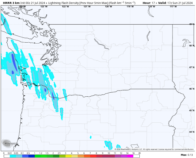
We'll start with the potential chance of thunderstorms on Sunday. This is using the HRRR high-resolution forecast for lightning flash density. We start at 10 AM Sunday.
At 10 AM, the HRRR shows thunderstorms moving northward along the WA coast and up the I-5 corridor.
By 12 PM, these storms are moving closer.
At noon, storms are impacting areas from the Olympic Mountains all the way to the Columbia River Gorge, moving toward the metro area and continuing to impact the I-5 corridor from Olympia to Portland.
Next, here's 2 PM.
By early afternoon, storms are moving through the San Juans, SW BC, the Kitsap Peninsula, and are near the metro area. After this, storms will continue moving north and slightly east, weakening as they do so.
The graphic below is outdated. See the graphic in the update above for the latest information.
Thunderstorms are even more likely over the Eastern Oregon, the Oregon Cascades, and parts of the Washington Cascades. Due to this, there are significant dry lightning concerns, as little to no precipitation is expected with any thunderstorm. Below is the NWS Storm Prediction Center (SPC) outlook for Sunday.
This outlook shows a dry thunderstorm threat for the Central and Southern WA Cascades, the I-5 corridor from Lewis County to Eugene, and most of the Oregon Cascades. The red shaded area over SE Oregon has an even higher potential for dry thunderstorms, which is concerning due to the fact that multiple major fires are already active in these areas.
Fire weather conditions will not be helped by temperatures on Sunday, as seen below in the NWS NBM forecast for highs.
On Sunday, the lowlands will reach the mid 70s to mid 80s, hottest from Seattle south and in the valleys. The Willamette Valley will reach the low to mid 80s, and the coast will cool to the mid to upper 60s (low 60s at the beaches). However, Eastern Washington will be dangerously hot, with highs in the mid 100s to low 110s. Some locations (in valleys and the lower Columbia Basin) have a chance of reaching the mid 110s, extremely dangerous levels if you are outside.
Due to the combination of dry thunderstorms, extreme heat, and expected winds gusting 25-40 mph across the region, a vast area of Eastern WA & OR is under Red Flag Warnings, as seen below.
Nearly the entirety of Oregon, except for parts of the northern tier, is under a Red Flag Warning, while in Washington, the entirety of the Cascades, the Olympics, and most of Chelan & Okanogan Counties are all under Red Flag Warnings.
Monday doesn't bring much (if any) relief for fire weather conditions. Temperatures are expected to drop (described in the previous blog post), but wind will increase due to the influx of somewhat cooler air. Below is the European model forecast for peak wind by Monday night.
This is concerning. Areas of Eastern Oregon, the OR & WA Cascades, the Columbia Gorge, and the Kittitas Valley are all expected to gust 30-45 mph, with isolated gusts of 45-50 mph for the Kittitas Valley and Columbia River Gorge. These winds are very problematic for fire spread, especially since they will be accompanied by relative humidity of 10-40%.
Finally, let's take a look at the forecast for smoke aloft on Sunday. Note: Expect degraded air quality due to surface smoke across Eastern Washington at times on Sunday, especially in the morning.
Below is the HRRR forecast for smoke aloft around sunrise.
Notice light to moderate concentrations across Western WA, with heavy concentrations over Oregon.
By midday, concentrations are heavier across the region.
By around midday, moderate to heavy smoke aloft is moving over nearly all of Washington, except the NE section.
By sunset, the impacts of another windy day are apparent.
You can tell that by Sunday night, many smoke plumes have been active across the region. Heavy smoke concentrations are present over Eastern Oregon and Washington, with light to moderate concentrations of smoke aloft west of the Cascades.
In short...a lot is happening over the next couple days. Stay tuned for more updates, do your part to prevent fires, and keep an eye to the sky!


It was not thunderstorms yet, but just had to come in the house from outside because of light rain.
ReplyDeleteCongratulations on your 700th blog! Nice job!_
ReplyDelete