FastCast--Wednesday, July 24 to Sunday, July 28:
After weeks of hot temperatures, and a record-setting 17 straight 80°+ days in Seattle, Western Washington is back to near-normal temperatures. This comes at the expense of Eastern Washington, since cooler conditions to the west bring gusty winds and low humidity to the east. In the lowlands, expect areas of morning marine clouds each morning through Sunday. Highs will generally reach the mid 70s to low 80s, hottest on Friday and Saturday. Isolated locations near the water will remain in the low to mid 70s, while some areas inland and in valleys could reach the mid 80s. Low temperatures will be refreshing, generally in the low to mid 50s, except in the upper 50s in dense urban areas. Some outlying regions could drop to the upper 40s! Continue reading below for an update on the significant fire weather concerns across the Northwest over the next couple days.
--------------------------------------------------------------------
Continue reading the full blog below!
Although temperatures have mostly returned to normal across the Northwest, the most hazardous weather conditions of the year have been impacting the region over the past few days, and the next couple days won't be any different.
A large-scale dry thunderstorm event is expected to take place on Wednesday across Eastern Oregon and parts of Idaho. Massive amounts of lightning, combined with strong thunderstorm outflow winds, will lead to very dangerous fire conditions. Below is the NWS Storm Prediction Center (SPC) outlook for fire weather conditions on Wednesday.

The red shaded areas have a high risk of dry thunderstorms, while a somewhat lesser risk exists across the brown shaded areas. In addition to dry thunderstorms, some thunderstorms across Idaho and Eastern Oregon will be strong enough to warrant a risk of severe thunderstorms. This means even more lightning is possible. Areas in orange have a wind-related risk of dangerous fire weather. This includes the Washington Cascades and parts of Eastern Washington.
Let's take a look at the lightning potential for Wednesday afternoon, from the European model.

That is a massive amount of potential lightning across Eastern Oregon, parts of Idaho, and parts of California and Nevada. The most concerning part of this is that there are already hundreds of smaller fires and a few massive fires in the lightning area. New starts are almost a certainty, meaning that resources may have to be pulled from existing fires. Additionally, thunderstorms make it much harder for aircraft to fight fires.
For folks in Washington thinking that this thunderstorm outbreak won't impact us, remember that smoke from new and existing fires in Oregon has a decent chance of impacting Washington in the coming weeks and months. This is also the reason why it's important to monitor fires in British Columbia, where a massive lightning barrage sparked 100+ new fires on Sunday.
The other component of the fire weather setup is wind. Below is the European model forecast for peak winds on Wednesday.
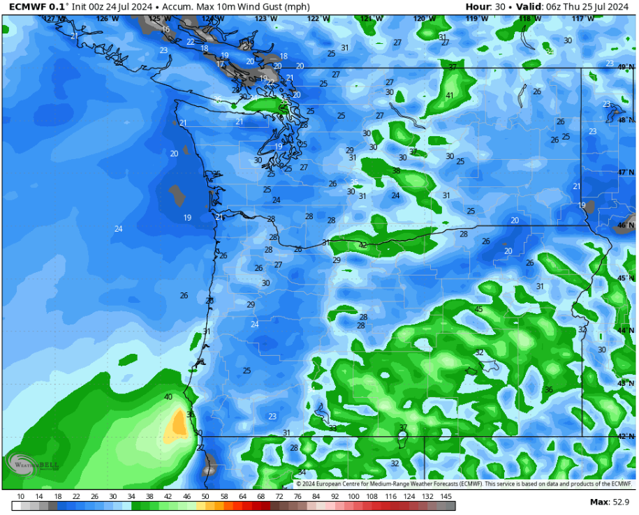
Notice erratic thunderstorm outflow winds across Eastern Oregon and parts of Idaho. These gusts, possibly 40-50 mph, will create extreme and erratic fire behavior, in addition to abundant dry lightning. Across Eastern Washington and Northern Oregon, gap winds along the east slopes of the Cascades will gust 35-45 mph, allowing existing fires to grow rapidly and promoting very fast fire spread on any new starts.
This is overall a very dangerous situation for the region, especially Oregon, which has been incredibly hard-hit by fires so far. If you are interested in tracking wildfires, I suggest downloading the Watch Duty app or checking out their wildfire map (click here). Scroll the map to the PNW to see current fires. Below is a screenshot of what the map looks like as of Tuesday night. Safe to say that it is already a very active fire season across the Northwest.

Regarding wildfire smoke, windy conditions around fires means that smoke will largely be concentrated in plumes downwind of fires. A new fire on Vancouver Island, near Sooke, may bring degraded air quality to San Juan and Whatcom Counties, while areas downwind from fires in Eastern Washington will experience degraded AQI.
Now, let's talk temperatures. After weeks of heat, Washington will largely have seasonable temperatures over the next few days. Below is the NWS NBM forecast for highs on Wednesday.

On Wednesday, lowland highs will reach the mid to upper 70s, while the coast reaches the mid to upper 60s, and the Willamette Valley reaches the low to mid 80s. Eastern Washington will reach the low 90s to low 100s, hottest in valleys and around the Tri-Cities.
Thursday's forecast is below, also from the NWS NBM model.

Notice that Thursday is significantly cooler across Eastern Washington, partially due to the strong winds on Wednesday evening. The lowlands will cool to the low to mid 70s, while the coast remains in the mid 60s, and the Willamette Valley drops to the upper 70s to low 80s. Eastern Washington will be the coolest it's been in weeks, with highs in the upper 70s to mid 80s.
Next, the NWS NBM forecast for Friday.

Friday will be a bit warmer across the region. The lowlands will reach the mid 70s to low 80s, the coast will reach the mid to upper 60s, and the Willamette Valley will reach the mid 80s. Eastern Washington will warm to the mid to upper 80s.
Finally, here's the NWS NBM forecast for Saturday.

On Saturday, the lowlands, coast, and Willamette Valley will be very similar to Friday's temperatures above. Eastern Washington will warm further, likely reaching the upper 80s to low 90s.
One final note...I will be traveling through Saturday, so I will not have any blogs until Sunday. To stay updated on current conditions, I recommend watching local meteorologist Michael Snyder's Pacific Northwest Weather Watch YouTube channel. A daily briefing is uploaded each morning!
Stay safe, be careful, and do everything you can to prevent wildfires!

No comments:
Post a Comment