***For information on cooling shelters, dial 2-1-1 or visit wa211.org.***
No FastCast tonight...continue reading below for an update on the heat wave and high fire danger across the Northwest.
Let's start by going through the upcoming temperatures. An important thing to note is that as the heat wave goes on, high and low temperatures will become problematic, as overnight lows won't offer much relief from the daytime heat. This is much more of an issue west of the Cascades, where air conditioning is less common.
Please remember to hydrate, stay out of the sun in the afternoon, and check up on the most vulnerable (children, the elderly, and pregnant mothers). Additionally, even though it is very hot, water temperatures are still in the 50s. Be very mindful of sun exposure, water temperatures, and the signs of heat exhaustion and heat stroke.
Finally, remember to NEVER keep children or pets in your car. After 30 minutes in 90° conditions, it is nearly 120° in your car. In the case of any suspected emergency, it is always best to call 9-1-1.
-------------------------------------------------------------
We'll use the NWS NBM high-resolution forecast for temperatures, as it has been quite accurate, especially around Puget Sound. Below are the forecasted highs for Saturday.

On Saturday, expect highs from Seattle north in the upper 70s to mid 80s, highs from Seattle south in the upper 80s to low 90s, and highs in the Willamette Valley in the upper 90s to low 100s. The coast will reach the mid to upper 70s, except the upper 60s on the beaches. Eastern Washington will reach the low 90s to low 100s.
Next, the NWS NBM forecast for Sunday morning's lows.
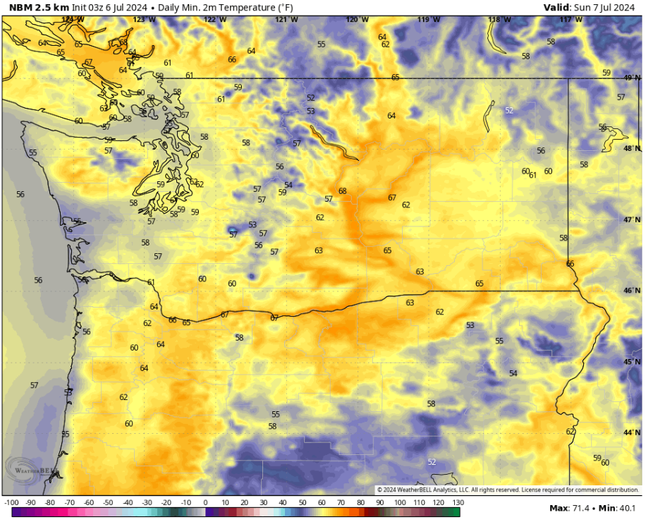
In the lowlands, expect lows in the upper 50s to low 60s, with coastal lows in the mid 50s. The Willamette Valley will only drop to the low to mid 60s, with Eastern Washington only dropping to the low 60s to low 70s.
The entire state will continue warming up on Sunday, as seen on the NWS NBM forecast below.

On Sunday, areas from Seattle north will reach the upper 70s near the water and the mid to upper 80s inland. From Seattle south, highs will reach the low to mid 90s. The Willamette Valley will reach the low 100s, while the coast will remain in the mid to upper 70s (except the upper 60s at the beaches). Eastern Washington will continue heating up, with highs reaching the upper 90s to mid 100s.
Overnight lows will also be warming up. Below are the forecasted lows for Monday morning.

On Monday morning, lows in the lowlands will only drop to the low to mid 60s, with the Willamette Valley dropping to the mid 60s. The coast will drop to the mid 50s. Eastern Washington will remain warm, dropping to the mid 60s to mid 70s.
The heat continues building on Monday, as seen below. However, notice that temperatures along the coast are getting a tad bit cooler.

On Monday, expect highs from Seattle north in the low to mid 80s, with locations closer to the mountains getting to the upper 80s to low 90s. From Seattle south, temperatures will reach the low to mid 90s, with areas from Tacoma southward possibly reaching the upper 90s. The Willamette Valley will likely reach the low to mid 100s, and Eastern Washington will reach the low to mid 100s, with isolated readings in the upper 100s. However, notice that the coast will be dropping a slight bit, reaching the upper 60s to mid 70s.
Tuesday morning's lows will likely be the worst across the lowlands, as seen below.

The lowlands will remain in the low to mid 60s, with the metro area potentially remaining in the upper 60s. The Willamette Valley will remain in the mid to upper 60s, but the coast will again cool to the mid 50s. Eastern Washington will remain in the upper 60s to mid 70s, with isolated areas not dropping out of the upper 70s.
Finally, we get to Tuesday, the hottest day for non-coastal areas west of the Cascades, and one of the hottest days east of the Cascades.

On Tuesday, highs from Seattle northward will reach the mid to upper 80s, with locations closer to the mountains in the low to mid 90s. Areas from Seattle southward will reach the mid to upper 90s, and the Willamette Valley will reach the low to mid 100s. Eastern Washington will be sweltering, with highs in the low 100s to low 110s, with isolated readings potentially into the mid 110s, very rare for the Northwest. However, as marine air begins to erode the heat, the coast will only reach the mid 70s, with the beaches likely in the mid 60s.
In addition to this extreme heat, fire danger is very high across the region. Below is a look at where Red Flag Warnings are in effect through Tuesday.

Red Flag Warnings are in effect for the entirety of the Cascades from Lewis County to the Canadian border. This means that any fires will spread rapidly, due to the combination of extreme heat, very low humidity, and breezy winds of 15-25 mph.
Let's take a look at that humidity. Below is the European model forecast for humidity on Saturday afternoon.

This forecast shows extremely low humidity values of 5-15% across most of Eastern Washington, which will contribute to very dangerous fire conditions. Additionally, the Willamette Valley will have humidity of 10-20%, while areas from Seattle southward will have 20-30% humidity. Even values of 30-40% (which will be seen in all non-coastal areas) have the potential to allow for rapid fire spread.
The bottom line...be extremely careful during this heat wave. Please don't do anything that could start a fire, as it will likely spread extremely fast and be difficult to contain. Stay safe and be cautious!

No comments:
Post a Comment