No FastCast tonight...continue reading tonight's update about the incoming thunderstorms and high fire danger.
Thunderstorms have already impacted Southern Oregon, from the coast near Coos Bay to the Cascades near Crater Lake and points eastward. There have already been many new small fires started as a result of these storms. This activity, due to a plume of monsoon moisture, is moving north into Northern Oregon and Washington.
The timing of storms is as follows...overnight into the early morning hours for Northern Oregon (on both sides of the Cascades) and parts of Southern Washington (also on both sides of the Cascades). The threat of thunderstorms continues into the morning with a slight chance of thunderstorms from 5-10 AM across the Puget Sound region (mainly south of Seattle), and a greater chance over southern parts of Eastern Washington and parts of the Cascades.
The threat ramps up for the Washington Cascades, the Olympics, and parts of Eastern Washington from late morning through 8-10 PM. There is a good chance of thunderstorms with a large amount of dry lightning during this time across the Cascades. Some forecasts are also calling for another round of storms near the lowlands during this time, so be prepared.
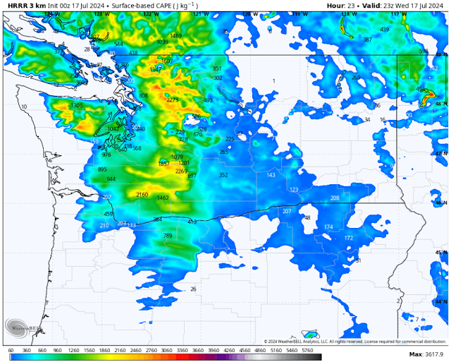
We'll start with the forecast for instability (CAPE index) on Wednesday afternoon, from the high-resolution HRRR forecast.
This forecast shows high CAPE values of 300-4000 across the region, most elevated in the Cascades. This shows that there is a good chance of thunderstorm development.
Concerningly, though, is the lack of rainfall with these storms. This is due to the fact that the storms are high-based, with little to no rainfall reaching the surface. Below is the European model forecast for total rain through Thursday.
This forecast doesn't paint a good picture. With very isolated pockets of rainfall over 0.2" with these storms, and most having 0-0.1" total, there is a high potential for dry lightning, where frequent lightning strikes are not accompanied by rainfall that could extinguish any fires.
Due to this, the NWS Storm Prediction Center (SPC) has put most of Washington and part of Oregon under a risk area for dry thunderstorms on Wednesday.
This risk area encompasses all of Washington from the Cascade foothills eastward into the Idaho Panhandle, and southward into parts of Oregon, from Portland eastward to the Idaho border, and southward toward Bend.
In that risk area is the highest chance for thunderstorms, especially over the Cascades. Below is the European model forecast for potential lightning probability on Wednesday afternoon.
Wow...the Cascades are a lightning bullseye, with a high probability for storms with large amounts of lightning on Wednesday afternoon. This does not bode well for new fire starts (and for growth of existing WA & OR fires due to gusty outflow winds from thunderstorms).
However, the high-resolution models believe that storms may not be limited to the Cascades, even in the afternoon. Below is the HRRR forecast for potential lightning on Wednesday, around 3-5 PM.
This forecast shows storms over the Cascades, with potential storms moving northward through the lowlands. This is a lesser probability event, but still possible. It will be important to have an eye to the sky and to take caution across the region on Wednesday. Even if no rain is falling, lightning is still possible.
Finally, let's talk Wednesday's temperatures. Below is the NWS NBM high-resolution temperature forecast.
This forecast shows lowland highs in the low to mid 80s, with isolated areas reaching the upper 80s. Meanwhile, the Willamette Valley reaches the upper 80s to low 90s, Eastern Washington reaches the upper 90s to mid 100s, and the coast remains in the mid 60s to low 70s.
It is important to note that temperatures across the region could be warmer or colder due to cloud cover. If clouds are thicker, take 3-5+ degrees off these highs, but if clouds move out earlier, temperatures could be warmer than expected.
The bottom line is that due to the threat of dry lightning and numerous thunderstorms, there is high fire danger and a very high risk of new fire starts on Wednesday. Please take caution and keep an eye to the sky!


No comments:
Post a Comment