Thursday, January 14, 2021

Calm Weather, Switch To Cooler Pattern Upcoming

After a very stormy last few weeks, it’s calm! Some light rain is possible in the next few days.

Below, the UW model shows rain totals through 4 PM Sunday. 


Expect 0.1-0.7 inches of rain, most falling Thursday night/Friday and Saturday night/Sunday. 

Patchy fog is possible on Friday night into Saturday. It looks like Saturday will be a partly sunny day.

Besides this rain, no weather events are in the near future. However, a pattern switch to colder weather is likely starting on the 20th/21st.

Take a look at the 10 day forecast for Puyallup. Notice a switch to colder temperatures (especially low temps) around the 20th.


I’m sure you notice the snow icons showing up next week and beyond. Some forecasts have been showing a chance of snow, but no definitive predictions can be made at this time. 

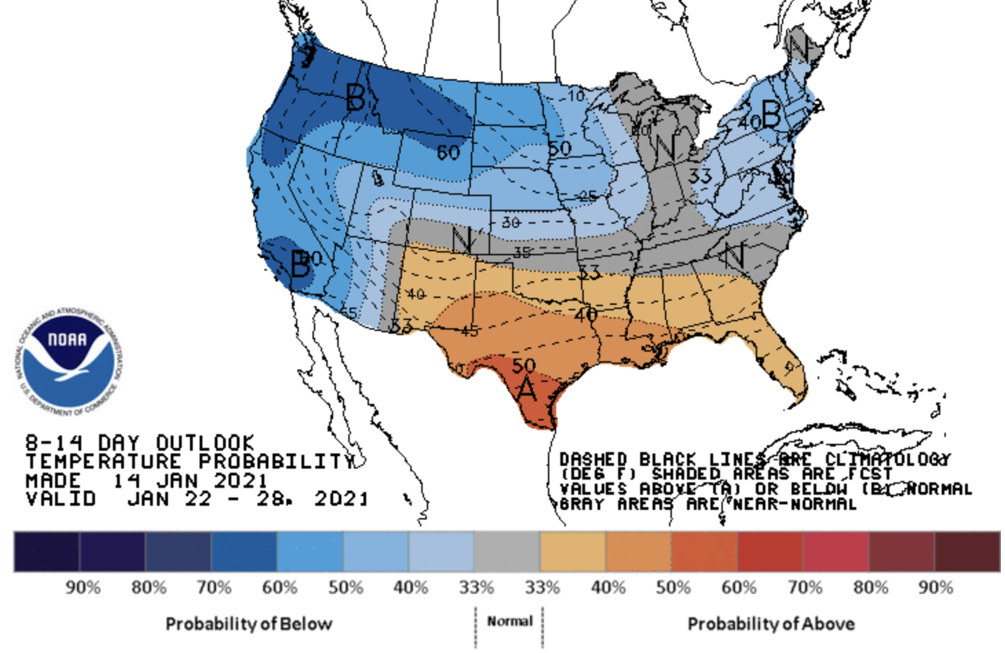
It is likely that the Pacific Northwest will experience colder than average temperatures. The NOAA/NWS Climate Prediction Center graphic below shows temperature departure from average for January 22-28.


The graph shows a 60% chance of below average temperatures across Washington.

Stay tuned as details about this setup get clearer!

Upcoming blog post: “Analysis of the Strength & Impacts of the January 13th Windstorm”

Wednesday, January 13, 2021

Morning Update: Strong Windstorm Overnight

A strong windstorm associated with a compact low pressure area moved through Western Washington overnight, bringing wind gusts of 40-70 mph to the area.

Main Points as of 8:30 AM Wednesday:

  • Over 500,000 people have lost power in Western WA
  • Peak winds in the South Sound were 40-60 mph
  • Winds are subsiding and will continue to calm throughout the day
Also...today is likely a rain-free day! Enjoy that!!

Below are the peak gusts recorded around the area overnight.


This windstorm was a small, compact low center. The strongest winds were fueled by very steep rises in air pressure as the low center pulled away. 

Regarding the original forecast, this event was mainly underplayed. The European forecast model picked up on the strong winds 2 days in advance, but was considered an outlier. 

Seeing the potential for a fast-developing storm last night, the forecasters at NWS Seattle issued a Wind Advisory for 40-50 mph gusts at 8 PM Tuesday. 

The actual winds gusted 40-70 mph, strongest near the water and north of Everett. This included a strong westerly wind surge down the Strait of Juan de Fuca overnight, with gusts of 60-70 mph. High ground saturation also played a part in causing many power outages across the region.

Expect a dry day today and tomorrow, with a chance of rain on Thursday night.

A list of peak wind gusts can be found below.

(All readings from area weather stations, gusts could differ at your location relative to these)


Puyallup: 40 mph

Tacoma: 55 mph

JBLM: 58 mph

Waller: 53 mph

Federal Way: 61 mph

S. Federal Way: 47 mph

Auburn: 43 mph

Fox Island: 56 mph

Eatonville: 38 mph

Olympia: 47 mph

Des Moines: 54 mph

SeaTac: 58 mph

Seattle: 51 mph

SR-520 Bridge: 56 mph

West Point (Seattle): 59 mph

Bellevue: 52 mph

Renton: 48 mph

Bothell: 47 mph

Everett: 48 mph

Port Townsend: 65 mph

Whidbey Island: 64 mph

Mount Vernon: 56 mph

Friday Harbor: 54 mph

Bellingham: 70 mph

Chinook Pass: 106 mph

Crystal Mountain: 91 mph

Alpental Mountain: 121 mph

Stevens Pass: 56 mph

Mount Baker: 79 mph

Paradise: 66 mph


Tuesday, January 12, 2021

Tuesday Night Update: Windstorm Overnight, Rain Ending Wednesday

Tuesday has been a very rainy day, with 1-2.5 inches of rain across the Puget Sound area, bringing January to 5-8 inches total. Tuesday has also been quite balmy, with the subtropical air of the atmospheric river bringing temperatures of 52-58 degrees.

We're not out of the woods yet. A windstorm is likely overnight, and a Wind Advisory (posted below) has been issued from 10 PM Tuesday to 6 AM Wednesday.


Expect peak winds gusting 40-50 mph in the Puget Sound area. 

Typically, this storm wouldn't be too out-of-the-ordinary for us. However, with the large amounts of rain in the past few weeks and particularly the last few days, the ground is very saturated, and there is a higher possibility of tree damage and power outages.

The graphic below from AccuWeather shows the dangers of saturated soil.


Saturated soil will be a big factor in the impacts of this windstorm. Below is the blend of 4 forecast models for Puyallup. 


You probably see the 60 mph gust being forecast by one of the models. While winds that strong aren't likely, but be prepared for the small chance that winds will gust above 50 mph.

Expect peak winds between 11 PM Tuesday and 6 AM Wednesday. 

I'm sure that most everyone is done with rain by now, but we have a few more hours of rain until a break of more than 24 hours!

The UW Model below shows an additional 0.3-1.2 inches of rain through 4 PM Wednesday. This will contribute to the ongoing river, urban, and small stream flooding in Western Washington.


Our 24-hour rain totals ending 9:25 PM Tuesday are below. Let's just say it's been pretty wet.


All of this rain, and the large amounts (7-12 inches) of rain since late December has pushed soil moisture (and the landslide threat) to high levels. 

The antecedent water index is a measure of the landslide threat. A reading of 0.02 is categorized as "wet" conditions. Currently, area readings are 0.03-0.07, quite wet!

How to read this: Colored lines (key at bottom) are the Index readings. The yellow shaded area is the forecast. The graph runs from 12/29 to 1/14. The black line around 0.02 is the measurement of "wet" which is typically an increased landslide threat. As you can see, we are quite above that mark currently.

In short: there is a high threat of landslides in Western Washington, something that will continue for the next few days.

Snow levels in the mountains have risen over 5,000 feet, and there is a danger of avalanches due to heavy rain. Be safe if you're in the backcountry.

Also, another round of tidal overflow (0.5-1 foot) is likely Wednesday morning.

Blog Recap:

  • Winds gusting 40-50 mph (locally higher) are expected from 10 PM Tuesday to 6 AM Wednesday
  • Highly saturated soils will present a higher than normal threat of tree damage and power outages
  • An additional 0.3-0.6 inches of rain is possible through midday Wednesday (locally higher amounts possible)
  • A high landslide threat remains through the next few days
  • Mountain avalanche danger and minor tidal overflow is also likely on Wednesday


Next Storm System Hits Western Washington

  8-26 Video Briefing: Next Storm System Hits Western Washington