Monday, June 12, 2023

Big Changes on Tuesday, Cooler & Wetter Extended Forecast

FastCast—Tuesday, June 13 to Friday, June 16:

A significant change is ahead for Western Washington on Tuesday. Highs reached the upper 70s to mid 80s across the area on Monday, with mostly sunny skies. However, expect a much different scene on Tuesday, with mostly cloudy conditions (with some sun possible in the afternoon). Tuesday’s highs will drop to the mid 60s to low 70s across the lowlands, and the influx of marine air will bring breezy winds gusting 20-35 mph in the lowlands, 30-40 mph along the Strait and on Northern Whidbey Island, and 35-45 mph in Eastern Washington. Winds will peak in the afternoon & evening. Wednesday will bring morning clouds and potential afternoon clearing, with highs in the upper 60s to low 70s, and Thursday will be partly sunny, with highs in the upper 60s to low 70s again. Friday will be mostly cloudy, with highs in the upper 60s and a chance of showers late in the evening. Through the week, expect lows in the upper 40s to low 50s.

———————————————————————

Continue reading the full blog below!

A much cooler day is expected on Tuesday across Western Washington, as the overall pattern trends cooler and closer to average (likely below average by Saturday, which will make for a cool & cloudy Father’s Day/Juneteenth weekend, but more on that in a later blog). 

Below is the NAM high-resolution forecast for highs on Tuesday.


Expect highs in the lowlands to be in the mid 60s to low 70s, in the mid 50s on the coast, and in the upper 80s to mid 90s in Eastern Washington.

Temperatures will drop steadily through the evening as marine air flows across the entire state. This will be a strong marine push, and will bring gusty winds for most of the region. Below is the European model forecast for wind gusts on Tuesday afternoon.


Expect gusts of 20-35 mph in Western Washington, except 30-40 mph near the Strait and on northern Whidbey Island. Eastern Washington will have stronger winds, with gusts of 35-45 mph (locally higher) in the afternoon and evening.

By 6 PM Tuesday, temperatures across the state will be substantially cooler than 24 hours previous as the strong marine push arrives. Below is the NAM forecast for 24-hour temperature difference at 6 PM Tuesday.


Expect a 10-25ยบ decline in temperatures versus what they were on Monday across the lowlands. Notice that at this time (6 PM), the marine air is moving across Eastern WA, with a line almost down the middle of the region showing where temperatures will be cooler or warmer than 6 PM Monday.

As we continue through the week, temperatures across Washington will stabilize near seasonal averages. Below is the NAM forecast for Wednesday’s highs.


On Wednesday, expect lowland highs in the mid to upper 60s, in the mid to upper 50s on the coast, and in the mid to upper 70s in Eastern Washington.

Thursday will benefit from a brief high pressure ridge that will increase temperatures, as seen on the NWS NBM model.


Expect Thursday’s highs to be in the mid 60s to low 70s in the lowlands, in the upper 50s to low 60s on the coast, and in the low 70s to low 80s in Eastern Washington.

However, changes are afoot in the extended forecast, which goes from Father’s Day (June 18) to the following Thursday (June 22). These extended outlooks are from the NWS Climate Prediction Center.

First, the CPC temperature outlook for June 18-22.


This is quite a change from recent outlooks! This shows a 60-80% probability of below average temperatures for the Pacific Northwest around June 18-22.

Next, the CPC precipitation outlook, also for June 18-22.


This outlook shows a 40-50% probability of above average precipitation across the entire Western US, with a 50-60% probability centered on Idaho, Northern Utah, NE Nevada, and Western Wyoming.

Stay tuned for a look at the Father’s Day/Juneteenth weekend forecast later this week. Spoiler: it looks to be on the chilly side.

Saturday, June 10, 2023

Will Current Dry Conditions Impact Wildfire Season?

It's easy to tell that current conditions are quite dry across Washington state. Even with rain on Friday & Saturday, overall conditions will remain quite dry. This blog post will look at the current statistics and what they mean for the upcoming wildfire season.

Let's start with a key statistic...precipitation departure from average. We will use the very informative graphics from the Western Regional Climate Center (WRCC), starting with precipitation percent of average over the past month.


This is not a good sign. Most of Western Washington has below 5% to about 25% of average precipitation for this time. Eastern WA isn't doing much better, with below 5% to about 70% of average in most areas, with isolated areas with 90%+ of average.

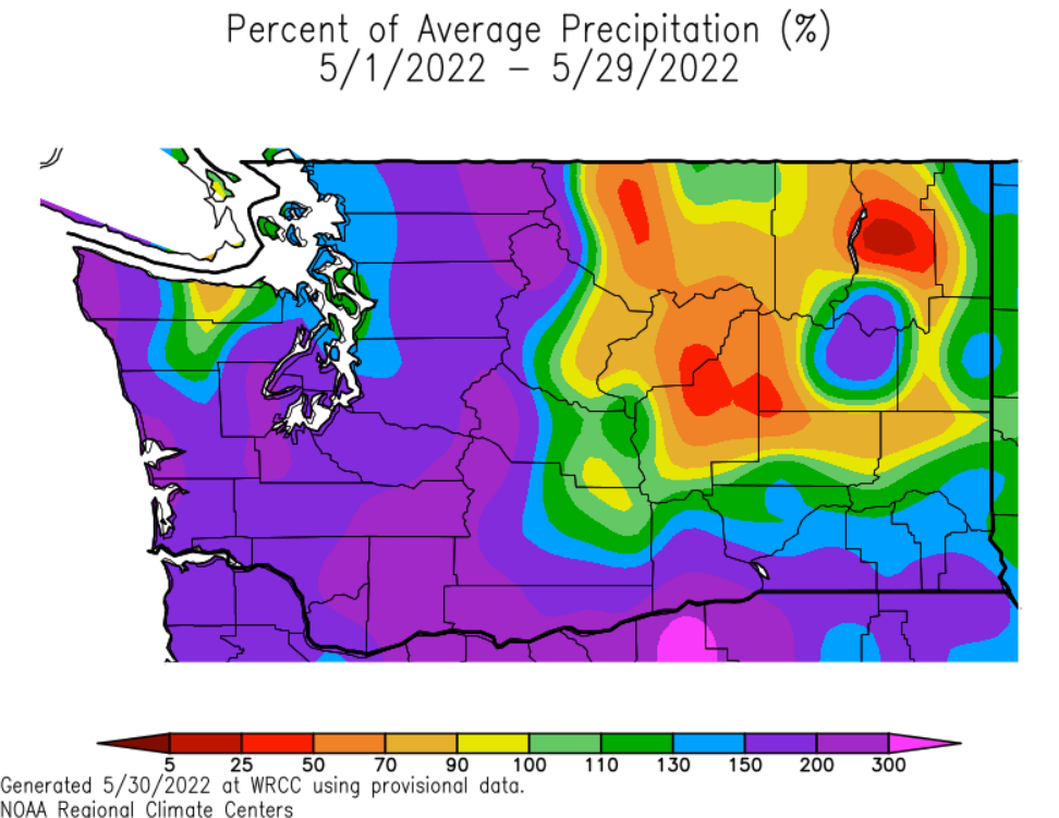
This is made even worse if you compare this current graphic to the same graphic from May 2022. The difference is staggering.


May 2022 saw 130-300% of average precipitation across Western WA, the complete opposite of this year. Areas of below-average precipitation were confined to relatively small parts of Eastern WA.

The comparison between these two graphics suggests that spring 2023 is far drier than 2022, not a good sign for wildfire season.

Another important metric when determining if wildfire season will start earlier is the snowpack. We will compare June 8, 2023 and May 30, 2022.

Below is the USDA/NRCS National Water and Climate Center snowpack graphic as of June 8.


Snowpack is currently far below normal for most of Washington's mountains, with the exception of the above-normal southern Cascades. All other regions have 2-43% of normal snowpack.

This is, again, a huge contrast to last year. May 30, 2022 is below.


Just over one year ago, Washington's snowpack was at 140-290% of normal, meaning that we currently have less than 1/4 of 2022's late spring snowpack for most areas.

What is the difference? A warm spring. This spring has seen much higher average temperatures than 2022. Let's take a look at the comparison using WRCC graphics again.


For May and early June, the entire state of Washington has been 4-8° above average, except for Island County, Western Whatcom & Skagit Counties, the coast, and Kitsap Peninsula, which have all been 2° below average to 2° above average.

Let's compare this to May 2022.


In spring 2022, the entire state of Washington was 2-6° below average, a total change from our current situation.

So...we have made it clear that rain and snowpack are far lower than 2022 and temperature is far higher this year than 2022. This increases the risk for an early start to wildfire season.

However, even though wildfire risk has increased and conditions are drier and hotter, reservoir storage is near average. 

Below is the graph for reservoir storage in the Yakima River system as of June 8th.


The blue line is our current year, the green is last year, and red is average. Notice that current reservoir storage increased dramatically in May, reaching very near average as of early June.

Let's take a look at a similar graph for the City of Seattle's reservoir system, which comprises a few reservoirs in Western Washington.


Notice that Seattle's reservoir levels also increased substantially in May, and remain near average in early June.

The key takeaway here is that despite dwindling snowpack, little rain, and warmer temperatures, water supply is good, which helps crews fight fires. 

In conclusion, current conditions suggest that an earlier start to wildfire season is possible, especially in comparison to 2022. Remember to check out the links on the right side of the blog for updated wildfire information as the season gets started. 

Thursday, June 8, 2023

Showers on Friday, Brief Cooldown Expected

 FastCast--Thursday, June 8 to Tuesday, June 13:

After a hot day on Wednesday, with temperatures reaching the mid to upper 80s across the lowlands, cooler and cloudier weather is ahead for Thursday, Friday, and early Saturday, before temperatures rise again from Sunday onward. Expect mostly cloudy conditions due to high clouds for the remainder of Thursday, with highs reaching the mid 70s. Friday will bring a chance of showers to the lowlands, with showers moving from SE to NW. Showers are most likely early Friday morning and then again late Friday evening into early Saturday morning. Most areas will likely get some rain, with the most likely amounts being 0.1-0.25". Some isolated areas will get higher or lower amounts. The coast and areas from Kelso southward will likely get a trace to 0.1" of rain. Highs on Friday will plummet to the low 60s. Temperatures will rebound into the upper 60s to low 70s on Saturday, with morning clouds and afternoon sun. Warmer conditions continue on Sunday, with sunny skies and highs in the upper 70s to low 80s, then even warmer on Monday, likely in the low to mid 80s. Temperatures will decrease with partly cloudy skies and highs in the mid to upper 70s on Tuesday. Throughout the FastCast period, expect lows in the low to mid 50s, except in the upper 50s on Tuesday morning.

------------------------------------------------------------

Continue reading the full blog below!

A big (but brief) cooldown is ahead for the entire state on Friday, as showers, clouds, and marine air brings a refreshing break from a warm few days. 

Below is the NAM high-resolution forecast showing 24-hour temperature difference at 4 PM Friday.


Temperatures on Friday will be 10-15° cooler in the lowlands and a whopping 10-35° cooler in Eastern WA and the Cascades. 

So what will those highs be? Let's take a look at the NAM high-resolution forecast for Friday's highs, seen below.


This is significantly cooler than any of the past few days. Expect lowland highs in the upper 50s to low 60s (this model does run a few degrees cool, so mostly low 60s are expected). The exception will be the coast, where highs will likely top out in the mid 50s. Eastern Washington will also be much cooler, with highs in the low to mid 70s.

Now...what you've all been waiting for...the rain forecast! The first rain of June is expected on Friday for most of the lowlands, but there will be even more rain in Eastern Washington! Let's take a look at some forecasts.

First, the NAM high-resolution rain forecast through 5 PM Saturday.


Note that stronger showers will bring 0.5-1.5" of rain across parts of the Cascades and Eastern WA north of I-90. In the lowlands, expect 0.1-0.3" of rain, with isolated higher totals from Shelton to Quilcene and north of Bellingham. The southern tier of WA (East & West) and the coast will get a trace to 0.15", with the exception of the Cascades and Blue Mountains.

Next, let's take a look at the European model's rain forecast through Saturday night.


The European model's forecast shows significant rain for Eastern WA from I-90 northward, including Spokane, with 1-2" in these areas. This could cause flooding if it occurs in a short timeframe. This forecast shows more rain west of the Cascades (except the coast), with 0.1-0.3" from Portland northward. The coast and Eastern WA from I-90 southward will get a trace to 0.1".

Finally, the UW high-resolution forecast, showing total rain through 5 PM Saturday.


The UW forecast shows heavy rain for most of Eastern WA north of I-90 and around Spokane, with totals of 0.3-1" possible. This forecast shows less rain for the lowlands, with a trace to 0.15" for most of the lowlands and 0.1-0.3" in the foothills.

Overall, any rain that we can get will be beneficial across the state, since we are heading into wildfire season far drier than normal. Enjoy the brief cooldown!

Next Storm System Hits Western Washington

  8-26 Video Briefing: Next Storm System Hits Western Washington