Tuesday, December 20, 2022

Frigid Air Arrives, Lingering Snow Showers

 No FastCast tonight...continue reading the full blog below.

------------------------------------------------------------------------------

First the snow, then the cold. It has been a wild 24 hours across Washington State, including significant lowland snow from Seattle northward, the now-lifted closures of all mountain passes, wind chills below zero in Whatcom County, and a plethora of snow and cold-related impacts across Eastern Washington. Due to cold temperatures, any snow that has fallen will remain and freeze over across the state.

As winter weather continues to impact Washington State, we will forecast it day-by-day on the blog, so stay tuned each night for new information.

Let's start with the European model forecast for Wednesday morning's lows.


Expect areas from Everett southward to drop into the mid to upper 20s, coldest east of I-5. Areas from Everett north will drop to the upper single digits to low 20s. Eastern Washington will be hazardous, with lows of 5 below to 15 above.

As seen in the European model below, highs on Wednesday have a hard time getting above freezing.


Expect lowland highs in the upper 20s to low 30s, except in the upper teens to low 20s in Whatcom County. Eastern Washington will only make it into the upper single digits to low 20s.

Wind chills will also be brutal across Eastern Washington, and quite frigid in Western Washington. The European model forecast for wind chills at 7 AM Wednesday is below.


On Wednesday morning, expect hazardous wind chills of 20 below to 10 above in Eastern Washington. In Western Washington, expect wind chills in the upper teens to low 20s south of Everett, and 10 below to 10 above from Mount Vernon northward.

By Wednesday evening, wind chills will be even colder, as seen on the European model forecast for 7 PM Wednesday.


On Wednesday evening, expect wind chills in the mid teens to low 20s for all of Western Washington south of Everett, including the coast. For areas north of Everett and on the Northern Olympic Peninsula, expect wind chills of 10 below to 15 above.

Eastern Washington will be hazardous, with wind chills of 25 below to 5 above. It is best to stay inside.

Finally, there are residual snow showers moving across parts of Western Washington due to Convergence Zone activity. We'll take a look at a few forecasts below to see how much snow to expect.

First, the European model, showing snow through Wednesday afternoon.


The European model shows light snow from Bellingham to Lakewood, with accumulations of a trace to 0.5 inches, except 1-2 inches near Tacoma.

Let's compare that to some other forecasts. Below is the NAM high-resolution model through Wednesday afternoon.


The NAM shows light snow from Mount Vernon to Longview, with accumulations of a trace to 1 inch, except 1-1.5 inches from South Seattle to Graham.

Lastly, let's take a look at the NWS NBM model, also through Wednesday afternoon.


The NBM model shows light snow from Mount Vernon to Olympia, with a trace to 1 inch of snow.

Major weather hazards remain, with the coldest temperatures expected on Thursday and freezing rain expected on Friday. Stay tuned and stay warmed!

Monday, December 19, 2022

Very Uncertain Snowstorm Forecast for Western Washington

No FastCast tonight. Continue reading below as we analyze forecast models to see what areas will receive snow, and how much may fall in this highly uncertain setup.

--------------------------------------

Forecast models are having a hard time agreeing on the placement of a low pressure system that will move through the region on Tuesday. The placement of the low pressure system will determine what areas receive rain, and which receive snow.

We will go through all the forecasts available and take a look at snow through Wednesday afternoon. The general idea is that areas from Seattle south will go from snow on Monday night to brief rain or rain/snow mix early Tuesday morning and back to snow midday/early afternoon Tuesday.

Snow amounts vary wildly between models, so we'll take a look at all the latest forecasts. But below, let's take a look at a general consensus, from south to north.

Olympia southward: 0-2"

Seattle to Pierce/Thurston Line: 0.5-6"

Seattle: 1-6"

Everett to Mount Vernon: 6-8"

Mount Vernon northward: 8-10"

Now...for all the forecasts, hence the large range of snow totals. Let's start with the GFS model, which is by far the snowiest (likely too snowy).


This is almost certainly far overdone for the Seattle area. However, totals of 6-8 inches aren't out of the question, but anything over 10" south of Everett is highly unlikely. Areas south of Seattle would receive 6-8 inches in this model, likely too high.

Now, let's look at the ultra-high resolution UW WRF forecast. This is a snowy solution for the region.


The UW high resolution forecast shows 5-7 inches for most areas from Tacoma northward, with isolated spots of 8-10 inches. Areas from Tacoma south get 2-4 inches.

However, these are the snowiest models, and others show significantly less. Let's take a look at the European model.


The European model is much less snowy, with 0.5-2 inches from Everett southward, and 3-9 inches from Mount Vernon north. 

Now, let's take a look at the American high-resolution models. First is the NAM model, shown below.


The NAM model is in the middle, showing 1-3 inches from Everett southward and 4-10 inches from Mount Vernon northward, an impactful snow for the North Interior.

Next, the National Weather Service NBM forecast.


This forecast is a bit snowier than the NAM, showing 3-4 inches from Seattle south, and 5-8 inches from North Seattle northward.

So, essentially, there is massive uncertainty among different forecasts. Some lean snowier, while others scour out cold air completely. The best thing to do is stay updated.

Updates are available on Twitter (link on top right of blog site), on local news stations, and on the Pacific Northwest Weather Watch YouTube channel. Stay tuned and stay safe! Much more winter weather is ahead this week...


Saturday, December 17, 2022

Lowland Snow & Very Cold Temperatures Due to a Modified Arctic Front

No FastCast today. Continue reading the full blog below.

A modified arctic front is moving south through British Columbia and will impact Western Washington from Sunday to Monday. The biggest impacts will be a dusting to 3 inches of snow and a noticeable decrease in temperatures area-wide.

Let’s take a look at what everyone wants to know: the snow forecasts. The best way to get a consensus of what will happen is to compare multiple forecast models.

The first chance of snow will be from Sunday morning to Monday morning, with precipitation starting in the north and moving south through the evening.

We will start with the European model, known to be accurate. All forecasts will show snow through 10 AM Monday (note: 0.1-0.4 more inches could fall after this).


The European model shows 0.2-3 inches of snow across the lowlands. The European model shows the most in a Convergence Zone from Seattle eastward, and 0.5-2 inches from Seattle north, with less snow (trace to 0.5”) from Seattle south. 

Now, the NAM model high-resolution forecast through 10 AM Monday.


The NAM shows 0.25-2 inches of snow area-wide, (including the coast) with up to 3-4 inches in Whatcom and Skagit Counties.

Finally, let’s look at the National Weather Service’s NBM model (through 10 AM Monday). This forecast blends multiple models together to get a forecast.


The NWS NBM shows 0.25-1 inch of snow for the entire region (including the coast), with up to 2 inches in the foothills.

In all forecasts, the mountains receive 6-12 inches of snow.

This modified arctic front will bring a noticeable decrease in temperatures from north to south, generally from Sunday morning to late Sunday night. 

Below is the European model forecast for low temperatures overnight Sunday into Monday morning.


Expect lows in the lowlands to be in the mid 20s to near 30ยบ, except frigid in the mid teens to low 20s in Whatcom and Skagit Counties. Eastern Washington will be getting colder, with lows in the single digits to low teens, except in the low to mid 20s in the lower Columbia Basin.

Monday won’t be very warm, with temperatures likely remaining below freezing for most areas of the state, as seen in the NAM model for high temperatures on Monday.


This may be a couple degrees on the cold side, but expect Monday’s highs around the lowlands to be in the upper 20s to low 30s, with even colder highs in the low to mid 20s in Whatcom and Skagit Counties.

Finally, it is important to consider the wind chill. Fraser outflow winds will gust 40-50 mph in Whatcom and San Juan Counties, with 10-20 mph gusts in the remainder of the lowlands. In the NWS NBM forecast below, you can see wind chills early Monday morning.


Expect brutal wind chills in the 5 below to 10 above range for Whatcom and San Juan Counties, with wind chills also in the 10 below to 15 above range for Eastern Washington. The rest of the lowlands will also be very cold, with wind chills in the low to mid 20s. Wind chills will be worst in the mornings, evenings, and overnight.

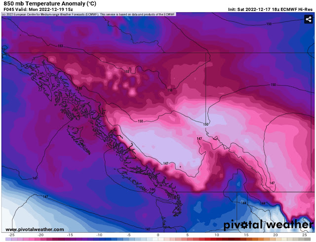
One more quick note…what is the source of all this cold and lowland snow? An arctic high (or an area of high pressure moving south from Northern Canada) has moved into British Columbia, and it is pushing its modified arctic front and associated frigid air into the Pacific Northwest. This can be seen below on the European model, showing temperature anomalies at 5,000 feet early Monday.


Notice the very cold air moving into the Pacific Northwest, and the downright frigid air in Interior BC/Alberta and Montana.

Stay tuned to my blog, Twitter, Pacific Northwest Weather Watch on YouTube, and local news stations for more updates, as this is not the end of the winter weather, with more expected throughout next week.

Next Storm System Hits Western Washington

  8-26 Video Briefing: Next Storm System Hits Western Washington